

Upper Mustang Trek
The Upper Mustang Trek enters the former Kingdom of Lo, a restricted Tibetan Buddhist enclave north of the Himalayan cre
Porter
$462 $420/porter
Flight from Kathmandu to Pokhara
$127 $115/person
Flight from Pokhara to Kathmandu
$127 $115/person
No payment required yet
Trip Overview
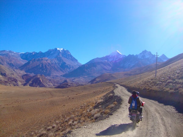
The Upper Mustang Trek enters the former Kingdom of Lo, a restricted Tibetan Buddhist enclave north of the Himalayan crest that was closed to outsiders until 1992 and still limits visitors through an expensive special permit. Beyond Kagbeni the landscape becomes genuinely otherworldly — eroded cliffs in red, ochre, and grey, ancient cave dwellings cut high into rock faces, and walled villages of whitewashed mud-brick set against a treeless plateau.
The trail climbs through Chele, Syangboche, Ghami, and Charang to the walled capital of Lo Manthang (3,770 m), where the royal palace, three great monasteries, and the enclosing city wall survive largely as they were built in the fifteenth century. An exploration day includes the extraordinary Chhoser sky caves, a multi-storey cliff dwelling carved into the rock. This is the most culturally intact Tibetan region accessible in Nepal.
Trip Highlights
The Walled City of Lo Manthang (3,770 m): Enter the fifteenth-century capital of the Kingdom of Lo, with its royal palace, monasteries, and intact city wall.
The Chhoser Sky Caves: Explore a multi-storey cliff dwelling carved into the rock face, one of the most remarkable sites in the Himalaya.
A Restricted Tibetan Kingdom: Trek a region closed to outsiders until 1992 that preserves Tibetan Buddhist culture more completely than Tibet itself.
Otherworldly Desert Landscape: Walk among eroded red and ochre cliffs, wind-carved canyons, and ancient cave systems on a treeless plateau.
Ghami, Dhakmar and Charang: Pass walled villages, the longest mani wall in Nepal, and monasteries holding centuries-old murals and manuscripts.
Itinerary
A 16-day trek into the restricted Kingdom of Lo, with return Jomsom flights, an exploration day at walled Lo Manthang, and the Chhoser sky caves.
1Day 1Arrival in Kathmandu (1,400 m)
Arrival in Kathmandu (1,400 m)
You arrive at Tribhuvan International Airport in Kathmandu (1,400 m) and are met by our representative for the transfer to your hotel in Thamel.
Your guide runs the pre-trek briefing. Upper Mustang is a restricted area — the former Kingdom of Lo was closed to outsiders entirely until 1992 and still requires a special permit, a licensed guide and a minimum of two trekkers. We go through the permit arrangements, the daily stages, and what to expect from a landscape completely unlike the rest of Nepal: this is Tibetan plateau country in the rain shadow of the Annapurnas, arid, wind-scoured and startlingly colourful.
Kit needs are different here too. It rarely rains, but the wind after midday is relentless, so a windproof shell, sunglasses, high-factor sun cream and a buff for the dust matter more than a heavy waterproof. The rest of the day is free. Overnight in Kathmandu.
2Day 2Drive from Kathmandu (1,400 m) to Pokhara (822 m)
Drive from Kathmandu (1,400 m) to Pokhara (822 m)
After breakfast we take the Prithvi Highway west out of the Kathmandu Valley toward Pokhara (822 m), following the Trishuli River through its gorge for much of the 200 km journey.
It is an easy day and a good introduction to middle-hill Nepal — terraced farmland, roadside bazaars, suspension footbridges and rafting groups on the green water below. We stop for lunch at a riverside restaurant partway along.
Pokhara is reached in the late afternoon, sitting on the shore of Phewa Lake with the Annapurna massif rising directly behind it. Tomorrow's flight to Jomsom is an early one and depends entirely on morning wind conditions in the Kali Gandaki, so we make sure bags are packed and ready tonight. Overnight in Pokhara.
3Day 3Fly from Pokhara (822 m) to Jomsom (2,700 m) and Trek to Kagbeni (2,800 m)
Fly from Pokhara (822 m) to Jomsom (2,700 m) and Trek to Kagbeni (2,800 m)
An early flight, because the Kali Gandaki wind picks up sharply through the morning and the Jomsom strip closes to traffic by mid-morning most days. The 20-minute flight is spectacular: the aircraft flies between Dhaulagiri (8,167 m) and Annapurna I (8,091 m), straight up the deepest gorge on earth.
Landing at Jomsom (2,700 m), the change is immediate — you have crossed the Himalaya into its rain shadow, and the green of Pokhara is replaced by bare rock, wind and enormous open sky.
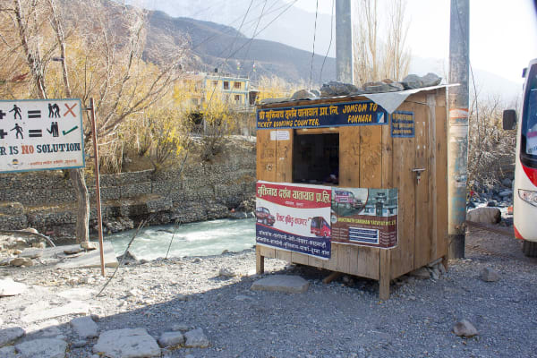
After breakfast we walk north up the wide gravel bed of the Kali Gandaki to Kagbeni (2,800 m), roughly three hours. Kagbeni is a medieval-looking village of mud-brick alleys, tunnels and a red-walled monastery, sitting where the Jhong Khola meets the main river. It is the checkpoint for Upper Mustang: beyond the police post here, the restricted permit begins. Overnight in Kagbeni.
4Day 4Trek from Kagbeni (2,800 m) to Chele (3,050 m)
Trek from Kagbeni (2,800 m) to Chele (3,050 m)
Permits are checked at the Kagbeni post and you enter Upper Mustang proper. From here on the number of trekkers drops to a handful.
The trail follows the east bank of the Kali Gandaki north through Tangbe and Chhusang, small oasis villages of whitewashed houses, apple orchards and barley fields set against completely barren hillsides. The contrast between irrigated green and raw red-brown rock is the defining image of Mustang.
Beyond Chhusang the route passes an extraordinary formation of eroded red cliffs riddled with ancient cave dwellings, crosses the river, and climbs to the village of Chele (3,050 m). From here the trail leaves the main river valley for good and starts working across a series of high passes and side canyons. The wind will have been at your back for most of the afternoon. Overnight in Chele.
5Day 5Trek from Chele (3,050 m) to Syangboche (3,475 m)
Trek from Chele (3,050 m) to Syangboche (3,475 m)
The days now settle into the rhythm of Mustang: climb a pass, drop into a canyon, climb the next one. Today crosses three.
From Chele the trail climbs steeply to the Taklam La (around 3,620 m), then continues over Dajori La with wide views back toward Nilgiri, Tilicho Peak and the Annapurnas behind you. The path descends to Samar (3,660 m), a small poplar-shaded village, before dropping into a deep gorge and climbing out again to the Bhena La and Yamda La.
The landscape is the reason to be here — layered cliffs in red, ochre, grey and purple, wind-carved into fins and hoodoos, with almost no vegetation. Along the way a short detour reaches the cave gompa of Rangbyung, a natural cavern filled with stalagmite formations regarded as sacred. The day finishes at Syangboche (3,475 m). Overnight in a teahouse.
6Day 6Trek from Syangboche (3,475 m) to Ghami (3,500 m)
Trek from Syangboche (3,475 m) to Ghami (3,500 m)
A shorter day with two passes. The trail climbs from Syangboche over the Syangboche La at about 3,850 m and drops to Ghiling (3,860 m), a village of flat-roofed houses among barley fields with a small gompa above it.
From Ghiling the route climbs again to the Nyi La at around 4,010 m — the highest point reached so far and, in effect, the boundary between lower and upper Lo. The view north from the top opens onto the plateau country that leads to Lo Manthang.
The descent leads to Ghami (3,500 m), one of the larger settlements in Mustang, sheltered behind poplar windbreaks in an otherwise wholly exposed landscape. Just beyond the village stands the longest mani wall in Nepal, several hundred metres of stacked prayer stones running across the hillside — walk it clockwise, as pilgrims do. Overnight in Ghami.
7Day 7Trek from Ghami (3,500 m) to Charang (3,560 m)
Trek from Ghami (3,500 m) to Charang (3,560 m)
The trail crosses the Ghami Khola on a suspension bridge and then passes the great mani wall before climbing toward Dhakmar (3,800 m), set beneath what are probably the most photographed cliffs in Mustang — an enormous wall of vivid red rock, pocked with caves.
Local legend ties the colour to Guru Rinpoche: when he subdued a demoness to allow the founding of Lo Gekar monastery, her blood is said to have stained these cliffs red. Whether or not you find that persuasive, the sight of them in afternoon light is remarkable.
The route climbs over the Mui La at around 4,170 m and descends to Charang (3,560 m), a substantial village strung along a canyon with a large red-walled fortress and monastery at its eastern end. The gompa holds an important collection of thangkas and statues, and the caretaker will usually open it for visitors. Overnight in Charang.
8Day 8Trek from Charang (3,560 m) to Lo Manthang (3,770 m)
Trek from Charang (3,560 m) to Lo Manthang (3,770 m)
The day you reach the walled city. The trail climbs out of the Charang canyon and crosses the Lo La at about 3,950 m, and from the top you get the first view of Lo Manthang on the plain below — a compact rectangle of whitewashed buildings entirely enclosed by a mud-brick wall, with the Tibetan border ridge behind it.
The descent to the city takes about an hour across open plateau. Lo Manthang (3,770 m) was founded in 1380 and served as the capital of the Kingdom of Lo for six centuries; the royal palace still stands, and the last king, Jigme Dorje Palbar Bista, held the title until Nepal abolished the monarchy in 2008.
Inside the walls the city is a maze of narrow alleys with roughly 150 households, four major monasteries and no vehicles. Arriving in the early afternoon leaves time to walk the perimeter and get oriented. Overnight in Lo Manthang.
9Day 9Exploration Day in Lo Manthang (3,770 m) and Day Trip to Chhoser Cave (3,800 m)
Exploration Day in Lo Manthang (3,770 m) and Day Trip to Chhoser Cave (3,800 m)
A full day in and around the capital. The morning is usually given to the city's monasteries: Jampa Lhakhang, dating from 1448 and holding a vast clay Maitreya Buddha; Thubchen Gompa, a huge assembly hall with painted columns; and Chodey Gompa, still the main working monastery. Several were restored over two decades by an international conservation project and the murals are extraordinary.
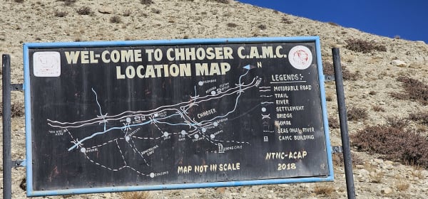
In the afternoon we ride or walk north to Chhoser (3,800 m), close to the Tibetan border, to visit the Jhong cave complex — a five-storey warren of around forty chambers cut into a sheer cliff face, connected by internal ladders and shafts. Believed to be over 2,500 years old, its original purpose is still debated: dwellings, meditation cells, burial chambers or refuge during raids.
The Nyphu cave monastery nearby is built into the rock in similar fashion. Overnight in Lo Manthang.
10Day 10Trek from Lo Manthang (3,770 m) to Dhakmar (3,800 m)
Trek from Lo Manthang (3,770 m) to Dhakmar (3,800 m)
We leave Lo Manthang and begin the return, taking a different line where the terrain allows so the walk back is not simply a repeat.
The trail crosses back over the Lo La and descends toward Ghar Gompa, one of the oldest monasteries in Nepal — founded in the 8th century and associated with Guru Rinpoche himself, predating Samye in Tibet. It is a small, unassuming red building in an empty landscape, and it is a genuinely significant site.
From Ghar Gompa the route continues over open plateau and descends to Dhakmar (3,800 m) beneath the red cliffs seen on the way north. Sleeping directly under them gives you the evening light, which is when the colour is at its most intense. The wind here is strong and constant through the afternoon. Overnight in Dhakmar.
11Day 11Trek from Dhakmar (3,800 m) to Ghiling (3,860 m)
Trek from Dhakmar (3,800 m) to Ghiling (3,860 m)
A steady day back through the heart of Lo. The trail descends from Dhakmar past the long mani wall to Ghami (3,500 m), then climbs the long pull back to the Nyi La (4,010 m) — the highest pass on the route, and harder in this direction.
From the top there is a last wide view north across the plateau toward Lo Manthang and the Tibetan border, worth stopping for before the trail drops away south.
The descent leads down to Ghiling (3,860 m), a compact village of flat-roofed stone houses set among barley terraces and sheltered by poplars, with a small gompa on the slope above. Afternoons in Mustang follow a reliable pattern — still and bright in the morning, then a hard, gritty wind from midday — so an early finish is welcome. Overnight in Ghiling.
12Day 12Trek from Ghiling (3,860 m) to Chhusang (3,050 m)
Trek from Ghiling (3,860 m) to Chhusang (3,050 m)
A long descending day that unwinds most of the height gained on the way in. The trail recrosses the Nyi La approach and works back south through the canyon country, over Yamda La and Bhena La and down to Samar (3,660 m).
Below Samar the path drops into the deep gorge and climbs back out to Chele, then descends steeply to the floor of the Kali Gandaki. Rejoining the main river valley after days in the side canyons is a distinct change of scale — the riverbed here is enormously wide and flat, braided with grey channels.
The trail follows it down to Chhusang (3,050 m), passing beneath the eroded red cliffs and their honeycomb of ancient caves. Chhusang is an oasis village of apple and apricot orchards behind stone walls. Overnight in Chhusang.
13Day 13Trek from Chhusang (3,050 m) to Jomsom (2,700 m)
Trek from Chhusang (3,050 m) to Jomsom (2,700 m)
The last walking day, and it is mostly downhill along the great gravel bed of the Kali Gandaki. The trail passes through Tangbe, with its narrow alleys and whitewashed chortens, and returns to Kagbeni (2,800 m), where you check out of the restricted area at the police post.
It is worth a last hour in Kagbeni's tunnelled lanes before continuing south. Below the village the valley widens further and the wind is squarely in your face for the final stretch — this is one of the windiest valleys in the world, and by early afternoon it is a real physical presence.
Keep an eye on the riverbed as you walk: the Kali Gandaki is famous for shaligrams, black ammonite fossils from the Tethys Sea that once lay where the Himalaya now stands, and which Hindus revere as manifestations of Vishnu. The day ends at Jomsom (2,700 m). Overnight in Jomsom.
14Day 14Fly from Jomsom (2,700 m) to Pokhara (822 m)
Fly from Jomsom (2,700 m) to Pokhara (822 m)
An early flight again, for the same reason as the inbound one — the Kali Gandaki wind makes the Jomsom strip unusable from mid-morning. Flights are scheduled at first light.
The 20-minute flight south runs down the gorge between Dhaulagiri and Annapurna, and the transition is remarkable: within a few minutes you go from brown high desert to the green, humid, terraced hills around Pokhara (822 m).
Jomsom flights are weather-dependent and cancellations do happen, so a buffer day before an international connection is always sensible; the road alternative to Pokhara takes a full day. Once in Pokhara the rest of the day is free — a hot shower, lunch by the lake, and an easy afternoon. Overnight in Pokhara.
15Day 15Drive from Pokhara (822 m) to Kathmandu (1,400 m)
Drive from Pokhara (822 m) to Kathmandu (1,400 m)
A relaxed morning by the lake before the drive east. If you are up early, sunrise on Annapurna and Machhapuchhre from the lakeside is worth it — you have just flown between those peaks twice.
We then take the Prithvi Highway back to Kathmandu (1,400 m), following the Marsyangdi and Trishuli rivers through the gorges. It is a full day on the road with a lunch stop, arriving in the capital in the late afternoon.
After checking in, the evening is free. Thamel is a short walk for souvenirs, and Mustang-specific ones are worth looking for — hand-woven wool, Tibetan-style jewellery and, in some shops, genuine shaligram fossils from the Kali Gandaki. Overnight in Kathmandu.
16Day 16Final Departure from Kathmandu (1,400 m)
Final Departure from Kathmandu (1,400 m)
Your last day in Nepal. If your flight leaves later, Boudhanath Stupa is a fitting place to finish after two weeks in Tibetan Buddhist country — the stupa is the centre of Kathmandu's Tibetan community and the monasteries around it belong to the same tradition as the gompas of Lo.
Our representative collects you from your hotel and transfers you to Tribhuvan International Airport about three hours before departure.
Upper Mustang is unlike any other trek in Nepal: a high desert plateau in the rain shadow of the Himalaya, a walled medieval capital, 2,500-year-old cliff caves, and monasteries older than almost anything in Tibet. If you want more of the same character, the Dolpo treks and the Limi Valley in Humla cover comparable Tibetan borderland country. Safe travels.
Inclusions & Exclusions
Return Pokhara-Jomsom flights, tourist bus transport, Kathmandu and Pokhara accommodation, teahouse lodging, all trekking meals, the Upper Mustang Restricted Area Permit and conservation area permits, a licensed guide, trekking map, first aid, and government taxes are included, while international flights, visa, insurance, personal gear, porter service, city meals, personal expenses, and tips are excluded.
What's Included
Airport pickup and drop-off services in Kathmandu.
Domestic flights from Pokhara to Jomsom and Jomsom to Pokhara as per the itinerary.
Tourist bus transportation from Kathmandu to Pokhara and back to Kathmandu.
Accommodation in Kathmandu with breakfast.
Accommodation in Pokhara with breakfast.
Accommodation in local teahouses during the trek.
Upper Mustang Restricted Area Permit, Annapurna Conservation Area Permit (ACAP), and required trekking permits.
Professional English-speaking licensed trekking guide.
Three meals a day (breakfast, lunch, and dinner) during the trek.
Group trekking map for route guidance.
First aid kit carried by the guide.
All government taxes, permit fees, and service charges.
What's Excluded
International flight tickets to and from Nepal.
Nepal entry visa fees.
Travel insurance, including emergency helicopter evacuation coverage.
Personal trekking equipment and clothing.
Porter services (available at an additional cost).
Lunch and dinner in Kathmandu and Pokhara.
Snacks, bottled water, hot showers, Wi-Fi, charging fees, and alcoholic or soft drinks.
Personal expenses such as laundry, phone calls, and souvenirs.
Tips for guides, drivers, and support staff.
Any additional accommodation, transportation, or expenses caused by domestic flight delays, bad weather, or other unforeseen circumstances beyond the itinerary.
Route Map
Explore the terrain map showing the trek route.
Loading map...
Altitude Profile
Pricing
Transparent per-person pricing based on group size, covering the services listed in the itinerary with no hidden charges.
Add-ons
Customize your trek with optional services such as porter support and other personalized arrangements at an additional cost.
Best Time to Trek
Upper Mustang has the longest and most unusual season in Nepal. Because it sits entirely in the rain shadow behind Annapurna and Dhaulagiri, the best months are March to November, and it is one of the very few Nepali treks that is genuinely good during the monsoon (June to August), when the rest of the country is under cloud and Mustang stays dry and clear.
The cultural high point is the Tiji festival at Lo Manthang, usually in May, a three-day masked dance ritual at the royal palace that draws visitors from across the region — book many months ahead if you want to be there. Winter is genuinely harsh, with much of the population migrating south and many villages closing, so December to February is not recommended.
For a month-by-month look at weather and trail conditions, see our guide to the best time to trek in Nepal.
Permits & Regulations
Upper Mustang is a restricted area and the rules are strict and non-negotiable. Entry requires the Upper Mustang Restricted Area Permit, which is issued only through a registered trekking agency, costs USD 500 per person for ten days plus USD 50 for each additional day, and is non-refundable and non-transferable. You also need the Annapurna Conservation Area Permit for the approach through Lower Mustang.
Regulations require a minimum of two trekkers travelling together on a single permit and a licensed guide throughout; solo trekking is not permitted under any circumstances. Permits are checked at the police post in Kagbeni and again at Lo Manthang. Our team handles the entire application, but we need clear passport copies, passport-sized photographs, and your Nepal visa details well in advance — permits cannot be arranged at short notice.
The fees and conditions for every restricted area are set out in our guide to restricted area permits in Nepal.
Travel Insurance
Travel insurance covering trekking to at least 4,500 m is required, comfortably above the trek's high points around Ghiling and Lo Manthang. Check the altitude clause explicitly, and confirm that small domestic aircraft are covered, since the Pokhara-Jomsom sector uses turboprops on a short mountain airstrip.
Given the expense and rigidity of the restricted-area permit, trip cancellation and curtailment cover matter unusually much on this trek — a permit is non-refundable once issued, so a cancellation for illness or a family emergency is a significant financial loss without insurance. You also need emergency helicopter evacuation and medical treatment cover, since Upper Mustang has no hospital and evacuation means a helicopter from Jomsom. Send us your policy number and the insurer's 24-hour emergency line well before departure.
Our guide to travel insurance for trekking in Nepal explains the altitude limits, evacuation terms and common exclusions to check before you buy.
Packing List
Upper Mustang is a high desert: intensely sunny, extremely dry, dusty, and windy, with cold nights. Bring waterproof trekking boots, three base layers, a fleece, an insulated down jacket, and a proper windproof shell jacket and trousers, which are essential rather than optional here. Add trekking trousers, a warm hat, a securely fitting sun hat, gloves, and wool socks. A sleeping bag rated to -10°C covers the coldest nights.
Sun and dust protection are critical: high-SPF sunscreen, strong lip balm, wraparound category 3 or 4 sunglasses, and a buff or scarf for the dust, which gets everywhere. Also pack a 30-litre daypack, trekking poles, a headlamp, a reusable bottle with purification tablets or a filter, heavy moisturiser, a personal first aid kit, quick-dry towel, toiletries, and a power bank. Remember the roughly 15 kg baggage limit on the Jomsom flight.
For the complete kit list, organised by the altitude you will reach, see our Nepal trekking packing list.
Accommodation, Food & Drinking Water
You stay in tourist-standard hotels in Kathmandu and Pokhara and in village teahouses and guesthouses throughout Upper Mustang. Standards are simpler than in Lower Mustang — twin rooms with foam mattresses and blankets, mostly shared bathrooms, dining rooms warmed by a stove in the evening — although Lo Manthang and Charang have several better-equipped guesthouses. Electricity is largely solar and can be intermittent.
Three meals a day are included on the trek. Menus are shorter than on the main circuits and built around dal bhat, Tibetan bread, thukpa, thenthuk, momos, noodles, potatoes, and eggs, reflecting the limited agriculture of a high desert where barley, buckwheat, and apples are the main crops. Butter tea is offered everywhere and is worth trying. Water comes from village supplies and must be treated with tablets, a filter, or a UV pen; carry at least two and a half litres a day, as the combination of altitude and dry air is genuinely dehydrating.
What the lodges are really like, from rooms and meals to showers and charging, is covered in our guide to teahouse trekking in Nepal.
Frequently Asked Questions
Find quick answers to common questions about the Upper Mustang Trek.
1How many hours do we walk each day?
Five to seven hours on most days. The route crosses a series of ridges and dry valleys rather than following one river, so almost every day involves several hundred metres of climbing and descending even where the net elevation change is small.
2Why is the permit so expensive?
The USD 500 fee for ten days is set by the Nepali government to limit visitor numbers and protect a culturally fragile region, with a portion intended for local development. It is non-refundable, non-transferable, and cannot be reduced or negotiated.
3Can I trek Upper Mustang alone?
No. Regulations require a minimum of two trekkers on a permit and a licensed guide throughout. If you are travelling solo we can pair you with another trekker on a fixed departure, or issue a permit for two at the appropriate cost.
4How difficult is the trek?
Moderate. There is no technical ground and the maximum altitude of around 3,860 m is lower than many Nepali treks, but the daily ridge crossings, dry air, wind, and eleven consecutive walking days make it more tiring than the profile suggests.
5What is the Tiji festival?
A three-day masked dance ritual held at the royal palace in Lo Manthang, usually in May, enacting the defeat of a demon and the restoration of harmony. It is one of the most striking cultural events in the Himalaya. Demand is high and accommodation must be booked many months ahead.
6Can I photograph the monasteries and caves?
Exterior photography is generally fine, but many gompas prohibit photographing interiors, murals, and statues, and some charge a fee. Always ask your guide first, and never photograph people, monks, or ceremonies without permission.
7Is mobile network and Wi-Fi available?
Coverage exists in the larger villages including Lo Manthang but is patchy elsewhere and drops out often. Some guesthouses sell Wi-Fi at slow speeds. Expect to be offline for stretches, and note that solar power limits how much anything runs.
8Where can I withdraw cash and charge devices?
Jomsom has the last reliable ATM before the restricted area and there are none beyond it. Carry all your Nepalese rupees from Pokhara or Jomsom. Charging in Upper Mustang is solar and limited, usually for a fee, so bring a large power bank.
9How cold does it get at night?
Nights at Lo Manthang, Ghiling, and Charang typically drop to around freezing or below in the main seasons, and considerably lower in late autumn. Days can be warm in the sun, so the daily temperature range is wide and layering matters.
10Can I leave extra luggage in Kathmandu or Pokhara?
Yes, and you should. Both hotels store anything you do not need free of charge until you return, which helps with the roughly 15 kg baggage limit on the Jomsom flight.
Gallery
Explore authentic moments, landscapes, and mountain views from the Upper Mustang Trek.
Trekking Guides & Articles
Upper Mustang Trek: The Walled Kingdom of Lo — A walled medieval capital at 3,840 m in a desert behind the Himalaya, with cave complexes, ochre cliffs and Tibetan Buddhism largely unchanged.
The Tiji Festival at Lo Manthang: Three Days of Masked Dance — Each May, monks at Lo Manthang perform three days of masked dances enacting the defeat of a demon and the driving out of evil for the year.
Monsoon Trekking in Nepal: Where to Go in June, July, and August — The monsoon closes most of Nepal's trails and opens the best ones.
Restricted Area Trekking Permits in Nepal: The Complete List — Eight regions of Nepal need a restricted-area permit, a licensed guide and a group of two.
Domestic Flights in Nepal: Lukla, Pokhara, Jomsom, and Delays — Several of Nepal's best treks begin with a short flight into the mountains.
Nepal Trekking Permits Explained: TIMS, Park Fees, and Restricted Areas — Every trek in Nepal needs paperwork, and the rules differ by region.
Fix Departure
This trek runs every week on the selected day. Choose custom dates for one-off departures.
Showing fixed departures in Oct 2026
Guest Reviews
Flawless from start to finish
“We booked Upper Mustang Trek on a friend's recommendation and it was the best advice we got all year. The views were spectacular at every turn and the trails far quieter than the busy routes I had rea...
Thomas Howard
Get in Touch
Tell us the dates you have in mind and roughly what you want out of the trek — one of our guides will reply, usually within 24 hours.
Email Us
info@greencompasstreks.com
Call Us
+977 9864379436
Office
Lakeside, Pokhara, Nepal
Office Hours
Sunday – Friday, 9:00 AM – 9:00 PM
Similar Treks
You might also like these treks

Porter
$462 $420/porter
Flight from Kathmandu to Pokhara
$127 $115/person
Flight from Pokhara to Kathmandu
$127 $115/person
No payment required yet