

Kanchenjunga North Base Camp Trek
The Kanchenjunga North Base Camp Trek takes the direct route to Pangpema (5,143 m), the base camp beneath the immense no
Porter
$462 $420/porter
No payment required yet
Trip Overview
The Kanchenjunga North Base Camp Trek takes the direct route to Pangpema (5,143 m), the base camp beneath the immense north face of the world's third-highest mountain. Flying to Bhadrapur and driving up through the tea country of Ilam to Taplejung, the trail follows the Tamor and Ghunsa rivers north through subtropical gorge, dense rhododendron forest, and then high glacial valleys.
The Sherpa village of Ghunsa (3,415 m) provides an acclimatization day, and a second rest day at Khambachen (4,050 m) makes this itinerary unusually well judged for altitude. From Lhonak the morning walk to Pangpema opens a view of the Kanchenjunga north face rising over 3,000 m directly ahead — one of the great sights in the Himalaya, and one that very few people ever see.
Trip Highlights
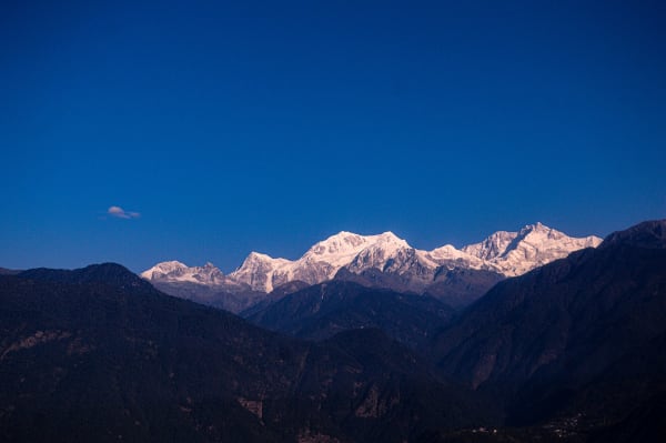
Pangpema at 5,143 m: Stand beneath the north face of Kanchenjunga (8,586 m), rising over 3,000 m directly above the glacier.
Two Full Acclimatization Days: Rest at Ghunsa (3,415 m) and Khambachen (4,050 m) for an unusually well-judged ascent profile.
Ghunsa, a High Sherpa Village: Stay in a traditional settlement at the heart of the Kanchenjunga Conservation Area.
Tea Gardens to Glacial Moraine: Travel from the tea estates of Ilam through subtropical gorge to high glacier country in a single trek.
A Restricted, Rarely Walked Valley: Trek permit-controlled country that receives a fraction of the visitors of Nepal's main regions.
Itinerary
A 14-day restricted-area trek up the Ghunsa valley to Pangpema (5,143 m) beneath Kanchenjunga's north face, with acclimatization days at Ghunsa and Khambachen.
1Day 1Arrival in Kathmandu (1,400 m)
Arrival in Kathmandu (1,400 m)
You arrive at Tribhuvan International Airport in Kathmandu (1,400 m), where our representative meets you and drives you to your hotel in Thamel.
Your guide runs the pre-trek briefing. The Kanchenjunga North Base Camp trek goes to Pangpema at 5,143 m, directly beneath the north face of Kanchenjunga (8,586 m) — the third-highest mountain on earth and the highest in India and Nepal's eastern border region. This is a restricted area requiring a special permit, a licensed guide and a minimum group size.
It is worth being realistic about what this trek involves. It is remote: the nearest road is days away, lodges are basic, and evacuation would be slow and expensive. Two acclimatisation days are built in for good reason. Your guide checks your kit thoroughly — a four-season sleeping bag and a serious down jacket are essential at Lhonak. Overnight in Kathmandu.
2Day 2Fly from Kathmandu (1,400 m) to Bhadrapur (91 m) and Drive to Taplejung (1,820 m)
Fly from Kathmandu (1,400 m) to Bhadrapur (91 m) and Drive to Taplejung (1,820 m)
An early flight east to Bhadrapur (91 m) in the far south-eastern corner of Nepal, close to the Indian border. The flight takes about 45 minutes and, on a clear morning, runs with the entire eastern Himalaya laid out along the northern horizon — Everest, Makalu and Kanchenjunga all visible from the same window.
Landing at 91 m puts you in the Terai: flat, hot and humid, a world away from the mountains. From the airstrip we drive north, and the road climbs steadily out of the plains into the hills through tea country — this is the Ilam district, whose tea gardens carpet the hillsides in bright green and are among the most photographed landscapes in eastern Nepal.
The drive to Taplejung (1,820 m) takes eight to ten hours on winding mountain road. Arriving in the evening, you have gained over 1,700 m since breakfast. Overnight in a lodge.
3Day 3Drive from Taplejung (1,820 m) to Sekathum (1,650 m) and Trek to Amjilosa (2,510 m)
Drive from Taplejung (1,820 m) to Sekathum (1,650 m) and Trek to Amjilosa (2,510 m)
A rough jeep transfer down to Sekathum (1,650 m) at the confluence of the Ghunsa and Simbua rivers, taking two to three hours on a track that is often barely a track at all.
The trekking starts here. The trail follows the Ghunsa Khola upstream into a steep, narrow gorge, crossing the river on suspension bridges and climbing steadily through subtropical forest. This lower section is hot and humid, thick with bamboo, ferns and cardamom plantations, with the river running loud below.
The climb to Amjilosa (2,510 m) is the sting in the day — a steep, sustained ascent up the gorge wall on a rocky path, gaining nearly 900 m. Amjilosa itself is a tiny cluster of lodges perched on a shelf with almost no flat ground. You are now properly committed: from here there is no road out. Overnight in Amjilosa.
4Day 4Trek from Amjilosa (2,510 m) to Ghunsa (3,415 m)
Trek from Amjilosa (2,510 m) to Ghunsa (3,415 m)
A long day climbing deeper into the valley, with the vegetation and the culture changing as you go.
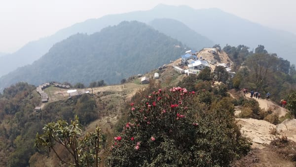
The trail continues up the Ghunsa Khola through Gyabla (2,725 m), a small Tibetan-influenced settlement, and then enters magnificent forest — rhododendron, fir and birch, hung with moss and lichen. Waterfalls drop across the trail and the gorge stays narrow for much of the morning. This is prime red panda habitat, though sightings are rare.
Above Phale, an old Tibetan refugee settlement with a small gompa and hand-woven carpets for sale, the valley finally opens out. Ghunsa (3,415 m) is the largest village on the route — a proper Tibetan settlement of wooden houses, prayer wheels, a monastery and a small hydro plant, set among pine forest with peaks rising on both sides. Overnight in Ghunsa.
5Day 5Acclimatization Day at Ghunsa (3,415 m)
Acclimatization Day at Ghunsa (3,415 m)
The first acclimatisation day, and a genuinely necessary one — from here the route climbs steadily to over 5,000 m with nowhere comfortable to retreat to.
As always, the rule is climb high and sleep low. The usual option is the ridge north-west of the village, gaining 400 to 600 m over a few hours, which opens up views of Jannu (7,710 m) — known locally as Kumbhakarna, and one of the most dramatic-looking mountains in Nepal, a sheer wall of rock and ice.
The alternative is a gentler walk around the village itself. Ghunsa is worth the time: the monastery is active, the Tibetan community here has been settled for generations, and there is a small hydroelectric scheme that supplies power to the village. Your guide will check how everyone is coping with the altitude before committing to the higher stages. Overnight in Ghunsa.
6Day 6Trek from Ghunsa (3,415 m) to Khambachen (4,050 m)
Trek from Ghunsa (3,415 m) to Khambachen (4,050 m)
The day the landscape turns high and alpine. The trail leaves Ghunsa heading north through pine and juniper forest along the river, climbing gradually at first.
After a couple of hours the trees give out entirely and the valley becomes a bare, rocky corridor. The route crosses a substantial landslide section — loose scree on a steep slope above the river, which requires care and is usually crossed one at a time early in the day before the sun loosens the surface. Your guide will assess it before committing.
Beyond the landslide the valley opens and Jannu (7,710 m) comes into full view ahead, an extraordinary mountain from this angle. Khambachen (4,050 m) is a small seasonal settlement of stone huts and a couple of basic lodges in a wide, treeless valley. It is cold and the facilities are minimal. Overnight in Khambachen.
7Day 7Acclimatization Day at Khambachen (4,050 m)
Acclimatization Day at Khambachen (4,050 m)
The second acclimatisation day, and the one that makes Pangpema achievable. Two nights at 4,050 m with a high walk in between is the standard and sensible way to prepare for sleeping at 4,792 m.
The usual excursion climbs the slopes toward Jannu Base Camp, gaining several hundred metres up the side valley for a closer view of Jannu's north face — a nearly vertical wall that mountaineers regard as one of the hardest objectives in the Himalaya. Even from a distance the scale of it is difficult to take in.
Blue sheep are common on these slopes and often visible in large herds, and Himalayan griffon vultures and lammergeiers ride the thermals above the valley. Gentler options include a short walk up the main valley or simply resting at the lodge. Drink steadily throughout the day. Overnight in Khambachen.
8Day 8Trek from Khambachen (4,050 m) to Lhonak (4,792 m)
Trek from Khambachen (4,050 m) to Lhonak (4,792 m)
A shorter day but a demanding one — over 700 m of ascent at an altitude where everything is slower.
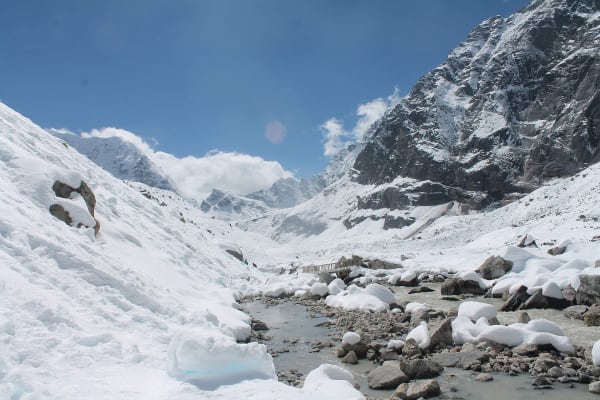
The trail climbs steadily up the valley on rough moraine and open scree, following the edge of the Kanchenjunga Glacier. There is no vegetation to speak of beyond low alpine cushion plants, and the surroundings become entirely rock, ice and sky. The route passes Ramtang and the ruins of an old monastery before the final climb.
Lhonak (4,792 m) is a bleak, beautiful spot: a handful of stone huts and basic lodges on a broad sandy flat beside the glacier, surrounded by peaks on every side. It is genuinely cold here and sleep is often broken at this altitude. Eat as much as you can, drink constantly, and get into your sleeping bag early — tomorrow starts before dawn. Overnight in Lhonak.
9Day 9Early Morning Hike from Lhonak (4,792 m) to Pangpema (5,143 m) and Return to Lhonak (4,792 m)
Early Morning Hike from Lhonak (4,792 m) to Pangpema (5,143 m) and Return to Lhonak (4,792 m)
The day the trek exists for. We set out early, following the lateral moraine of the Kanchenjunga Glacier north-east on a rough but not technical trail. It is around 350 m of ascent over three to four hours, slow going at this altitude.
Pangpema (5,143 m) — Kanchenjunga North Base Camp — is a flat grassy shelf above the glacier, and the view from it is one of the great sights in the Himalaya. The entire north face of Kanchenjunga (8,586 m) rises directly in front of you, more than 3,000 m of ice and rock in a single sweep, flanked by Wedge Peak, The Twins, Tent Peak and Nepal Peak.
Those with energy can climb the ridge behind base camp for another 200 m and an even wider panorama. We then descend the same route to Lhonak (4,792 m) for the night — going back down to sleep is the right call after a day at over 5,000 m. Overnight in Lhonak.
10Day 10Trek from Lhonak (4,792 m) to Ghunsa (3,415 m)
Trek from Lhonak (4,792 m) to Ghunsa (3,415 m)
A long descending day that gives back nearly 1,400 m, and the relief in your breathing is noticeable within the first hour.
The trail retraces the moraine down the valley past Ramtang to Khambachen (4,050 m), where we usually stop for lunch. From there it continues down, recrossing the landslide section — again taken carefully and one at a time — before the valley narrows and the first juniper and pine reappear.
The return to trees after several days above the treeline is a genuine pleasure, as is the warmth. The trail follows the river down to Ghunsa (3,415 m), arriving in the late afternoon. After the stone huts of Lhonak, Ghunsa's wooden houses and proper lodges feel positively comfortable. Overnight in Ghunsa.
11Day 11Trek from Ghunsa (3,415 m) to Amjilosa (2,510 m)
Trek from Ghunsa (3,415 m) to Amjilosa (2,510 m)
A long day descending back through the forested gorge, retracing the route in.
The trail drops from Ghunsa through Phale, with its Tibetan refugee settlement and small gompa, and into the thick rhododendron, fir and birch forest below. The moss-hung trees, waterfalls and enclosed gorge that felt like hard work on the way up are far more enjoyable going down.
The path continues through Gyabla (2,725 m) and then makes the long steep descent toward the river. The final section to Amjilosa (2,510 m) undulates along the gorge wall on a rocky trail that demands attention. The vegetation thickens back into bamboo and cardamom and the humidity returns — a marked change from the dry, thin air of the high valley. Overnight in Amjilosa.
12Day 12Trek from Amjilosa (2,510 m) to Sekathum (1,650 m) and Drive to Taplejung (1,820 m)
Trek from Amjilosa (2,510 m) to Sekathum (1,650 m) and Drive to Taplejung (1,820 m)
The final walking morning, and a steep one — the descent from Amjilosa loses around 860 m on a rocky trail down the gorge wall, which is hard on the knees after ten days of walking.
The trail follows the Ghunsa Khola down through subtropical forest, crossing suspension bridges, and reaches Sekathum (1,650 m) at the river confluence in the late morning. This is where the walking ends.
A jeep meets us for the rough two to three hour transfer back up to Taplejung (1,820 m) on the same rough track you came down. Arriving in the afternoon, there is time for a hot shower and a proper meal — the first of either for over a week. Tonight is the celebration dinner with your guide and porters. Overnight in Taplejung.
13Day 13Drive from Taplejung (1,820 m) to Bhadrapur (91 m) and Fly to Kathmandu (1,400 m)
Drive from Taplejung (1,820 m) to Bhadrapur (91 m) and Fly to Kathmandu (1,400 m)
A long travel day. The drive from Taplejung down to Bhadrapur (91 m) takes eight to ten hours, descending through the tea gardens of Ilam and out onto the Terai plains. It is a scenic road but a slow one, so we start early to make the afternoon flight.
The tea country is worth staying awake for — hillsides terraced in bright green, pickers working the rows, and factories where you can sometimes stop and taste. Ilam tea is among the best produced in Nepal.
The 45-minute flight from Bhadrapur to Kathmandu (1,400 m) runs west with the Himalaya along the northern horizon, and on a clear afternoon you can pick out Kanchenjunga behind you. Arriving in the capital, you transfer to your hotel. Overnight in Kathmandu.
14Day 14Departure from Kathmandu (1,400 m)
Departure from Kathmandu (1,400 m)
Your final day in Nepal. If your flight leaves later there is time for one more part of the Kathmandu Valley — Boudhanath Stupa, Pashupatinath Temple and Swayambhunath are all within a short drive.
Our representative collects you from your hotel and transfers you to Tribhuvan International Airport around three hours before your scheduled departure.
The Kanchenjunga North Base Camp trek is one of the most remote teahouse routes in Nepal, and one of the least walked — you will likely have seen more blue sheep than other trekkers. Standing at Pangpema beneath the north face of the world's third-highest mountain is a rare thing. If you would like to see the other side, the South Base Camp route reaches Oktang beneath the Yalung Glacier, and the full circuit links both. Safe travels.
Inclusions & Exclusions
Bhadrapur flights, all ground transport, Kathmandu and Taplejung accommodation, teahouse lodging, all trekking meals, restricted area and conservation permits, a licensed guide, trekking map, first aid, and government taxes are included, while international flights, visa, insurance, personal gear, porter service, city meals, personal expenses, and tips are excluded.
What's Included
Airport pickup and drop-off services in Kathmandu.
Domestic flights from Kathmandu to Bhadrapur and Bhadrapur to Kathmandu.
Ground transportation between Bhadrapur, Taplejung, and Sekathum as per the itinerary.
Accommodation in Kathmandu with breakfast.
Accommodation in Taplejung with breakfast.
Accommodation in local teahouses during the trek.
Kanchenjunga Restricted Area Permit and Kanchenjunga Conservation Area Permit.
Professional English-speaking licensed trekking guide.
Three meals a day (breakfast, lunch, and dinner) during the trek.
Group trekking map for route guidance.
First aid kit carried by the guide.
All government taxes, permit fees, and service charges.
What's Excluded
International flight tickets to and from Nepal.
Nepal entry visa fees.
Travel insurance, including emergency helicopter evacuation coverage.
Personal trekking equipment and clothing.
Porter services (available at an additional cost).
Lunch and dinner in Kathmandu.
Snacks, bottled water, hot showers, Wi-Fi, charging fees, and alcoholic or soft drinks.
Personal expenses such as laundry, phone calls, and souvenirs.
Tips for guides, drivers, and support staff.
Any additional accommodation, transportation, or expenses caused by domestic flight delays, bad weather, or other unforeseen circumstances beyond the itinerary.
Route Map
Explore the terrain map showing the trek route.
Loading map...
Altitude Profile
Pricing
Transparent per-person pricing based on group size, covering the services listed in the itinerary with no hidden charges.
Add-ons
Customize your trek with optional services such as porter support and other personalized arrangements at an additional cost.
Best Time to Trek
April to May and October to November are the only recommended seasons. Autumn brings the most settled weather and the clearest view of the north face from Pangpema, which is the entire point of the trek. Spring is warmer with rhododendron flowering through the Ghunsa valley, which is one of the finest forest displays in eastern Nepal.
Eastern Nepal takes more monsoon rain than the west, so June to September brings leeches, landslides on the Taplejung road, and heavy cloud. Winter closes Lhonak and Pangpema entirely and the upper lodges shut. Outside the two named windows this route is not viable.
For a month-by-month look at weather and trail conditions, see our guide to the best time to trek in Nepal.
Permits & Regulations
Kanchenjunga is a restricted area. You need the Kanchenjunga Restricted Area Permit, issued only through a registered trekking agency at USD 20 per person per week, together with the Kanchenjunga Conservation Area Permit and trekking registration. Permits are non-transferable and are checked at several posts along the Tamor and Ghunsa valleys.
Regulations require a minimum of two trekkers travelling together and a licensed guide throughout; solo trekking is not permitted. Our team handles the full application, but we need clear passport copies, passport-sized photographs, and your Nepal visa details in advance. The conservation area is co-managed with local committees, so small additional community fees may be collected at village checkpoints.
The fees and conditions for every restricted area are set out in our guide to restricted area permits in Nepal.
Travel Insurance
Travel insurance covering trekking to at least 5,500 m is mandatory, giving a margin over Pangpema at 5,143 m. Standard holiday policies routinely cap far lower and often exclude remote-area travel outright, so read both the altitude clause and the remoteness exclusions before purchasing rather than assuming your cover extends.
Emergency helicopter evacuation and repatriation cover is essential. From Khambachen, Lhonak, or Pangpema the nearest road is several days' walk, and evacuation means a helicopter flying a long distance from Biratnagar or Kathmandu, which operators dispatch only against a guarantee of payment. Also ensure cover for delayed or cancelled domestic flights on the Bhadrapur sector. Send us your policy number and the insurer's 24-hour emergency line before departure.
Our guide to travel insurance for trekking in Nepal explains the altitude limits, evacuation terms and common exclusions to check before you buy.
Altitude & Acclimatization
This itinerary is deliberately generous with acclimatization, including full rest days at both Ghunsa (3,415 m) and Khambachen (4,050 m). Two dedicated days on a fourteen-day trek is more than most Nepali routes provide, and it makes a substantial difference on a trail that sleeps at 4,780 m and walks to 5,143 m.
Pangpema is reached as an early-morning day return from Lhonak rather than as a place to sleep, which is the safest way to take a group that high. Your guide checks the group each evening for headache, disturbed sleep, appetite loss, and breathlessness at rest, and can add a night at Ghunsa or Khambachen if needed. Drink three to four litres a day, walk at a conversational pace, avoid alcohol above Ghunsa, and report symptoms early — there is no quick descent from Lhonak.
Prevention, symptoms and treatment are covered in depth in our guide to altitude sickness in Nepal.
Accommodation, Food & Drinking Water
You stay in a tourist-standard hotel in Kathmandu, in simple hotels at Bhadrapur and Taplejung, and in village teahouses at Amjilosa, Ghunsa, Khambachen, and Lhonak. Standards are basic by Everest or Annapurna measures — twin rooms with foam mattresses, shared or outdoor toilets, no hot showers above Ghunsa, and heating limited to the dining room. Lhonak in particular has only a handful of beds.
Three meals a day are included on the trek. Menus are short and repetitive, built around dal bhat with refills, noodle soup, fried rice, potatoes, eggs, chapati, and tea, because everything above Ghunsa is carried up on foot over several days. Tell us about dietary requirements well in advance, as substitutions cannot be arranged en route. Water comes from streams and lodge taps and must be treated with tablets, a filter, or a UV pen; bottled water is not reliably available on this route.
What the lodges are really like, from rooms and meals to showers and charging, is covered in our guide to teahouse trekking in Nepal.
Frequently Asked Questions
Find quick answers to common questions about the Kanchenjunga North Base Camp Trek.
1How many hours do we walk each day?
Six to eight hours on most days. The Pangpema day return from Lhonak is the longest at eight to ten hours from a pre-dawn start, and the Amjilosa to Ghunsa stage is a long day of steady climbing through the gorge.
2How does this compare with the full Kanchenjunga Circuit?
This route goes directly to the north base camp and returns down the same valley, taking fourteen days rather than twenty-one. It skips the Sele La crossing and the southern Oktang viewpoint, which makes it shorter, less committing, and considerably cheaper, while keeping the trek's most dramatic single objective.
3Can I trek Kanchenjunga alone?
No. Restricted-area regulations require a minimum of two trekkers on a permit and a licensed guide throughout. If you are travelling solo we can pair you with another trekker on a fixed departure or issue a permit for two at the corresponding cost.
4How reliable are the flights to Bhadrapur?
Reasonably reliable, since Bhadrapur is a lowland airport served by larger aircraft rather than a mountain strip. Poor visibility causes occasional delays but cancellations are less frequent than on Lukla or Juphal. The long drive to Taplejung is the more unpredictable part.
5Do we camp on this trek?
No. Every night is spent in a village lodge or hotel. The lodges above Ghunsa are basic, but there is permanent accommodation at every stop on this itinerary, which is one of its advantages over the full circuit.
6Is mobile network available?
There is patchy coverage at Taplejung, Sekathum, and Ghunsa and effectively none above Ghunsa. Expect to be offline for the upper part of the trek. Our guides carry a satellite communication device for emergencies.
7Where can I withdraw cash and charge devices?
Taplejung has the last reliable ATM and there are none beyond it, so carry all your Nepalese rupees from Kathmandu or Bhadrapur. Charging above Ghunsa is solar and limited, usually for a fee, so bring a large power bank and spare batteries.
8How cold does it get at the high lodges?
Khambachen and Lhonak typically fall to between -10°C and -20°C in the main seasons, colder with wind, and lodge heating is minimal. A sleeping bag rated to -20°C plus a liner is the right specification, and the Pangpema morning is colder still.
9What wildlife might we see?
The Kanchenjunga Conservation Area holds red panda in the mid-altitude forests, blue sheep and Himalayan tahr higher up, and outstanding birdlife including blood pheasant and lammergeier. Snow leopard are present in the upper valleys but effectively never seen.
10Can I leave extra luggage in Kathmandu?
Yes. Your Kathmandu hotel stores anything you do not need on the trail free of charge until you return, which helps with the baggage limits on the Bhadrapur flight.
Gallery
Explore authentic moments, landscapes, and mountain views from the Kanchenjunga North Base Camp Trek.
Trekking Guides & Articles
Kanchenjunga North Base Camp Trek: The Complete Guide — The direct route to Pangpema at 5,143 m, beneath a north face that rises more than 3,000 m in front of you.
Kanchenjunga Circuit Trek: Nepal's Remotest Major Trek — Three weeks in far-eastern Nepal to both base camps of the world's third-highest mountain, over a 4,792 m pass.
Kanchenjunga South Base Camp Trek: The Complete Guide — The shortest way into the Kanchenjunga massif: eleven days to the Oktang viewpoint at 4,730 m above the Yalung Glacier, where Kanchenjunga, Kabru.
Bokta Peak Climbing: The Complete Guide — One of the least-attempted permitted peaks in Nepal, on the southern rim of the Kanchenjunga massif.
Fix Departure
This trek runs every week on the selected day. Choose custom dates for one-off departures.
Showing fixed departures in Oct 2026
Guest Reviews
Beyond our expectations
“Kanchenjunga North Base Camp Trek was everything we hoped for and so much more. We learned so much about the villages, monasteries and local life from our guide. If you are considering this trek, just...
Benjamin Cruz
Get in Touch
Tell us the dates you have in mind and roughly what you want out of the trek — one of our guides will reply, usually within 24 hours.
Email Us
info@greencompasstreks.com
Call Us
+977 9864379436
Office
Lakeside, Pokhara, Nepal
Office Hours
Sunday – Friday, 9:00 AM – 9:00 PM
Similar Treks
You might also like these treks
Porter
$462 $420/porter
No payment required yet