

Rolwaling Valley Trek
The Rolwaling Valley Trek is one of Nepal's genuine wilderness routes, crossing from the remote Rolwaling Himal into the
Porter
$578 $525/porter
No payment required yet
Trip Overview
The Rolwaling Valley Trek is one of Nepal's genuine wilderness routes, crossing from the remote Rolwaling Himal into the Khumbu over the demanding Tashi Lapcha Pass (5,755 m). The valley sits directly west of Everest and is known in Sherpa tradition as a beyul, a hidden sacred valley. It sees a tiny fraction of the traffic on Nepal's main trails, and for most of the route you walk through villages, forests, and glacial basins with no other trekking groups in sight.
The journey climbs from Jagat through Simigaon and Bedding to the high settlement of Na (4,180 m), then works up the Trakarding Glacier to the foot of Tashi Lapcha before crossing into the Khumbu and descending to Thame, Namche Bazaar, and Lukla. This is a serious undertaking involving glacier travel, a high pass crossing, camping at remote high camps, and two acclimatization days — it is intended for experienced, well-prepared trekkers rather than as a first Himalayan trip.
Trip Highlights
Cross the Tashi Lapcha Pass (5,755 m): Traverse the glaciated pass linking the Rolwaling valley to the Khumbu, the highest point and crux of the trek.
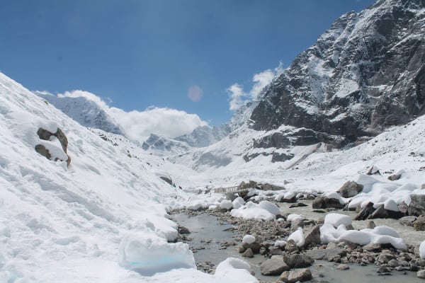
Walk the Trakarding Glacier: Follow the moraine and ice of one of Nepal's most impressive and least visited glacier systems.
The Hidden Valley of Rolwaling: Trek through a sacred beyul valley of Sherpa tradition that receives only a handful of groups each season.
Finish in the Khumbu: Descend to Thame, Namche Bazaar, and Lukla, joining the classic Everest trail for the final days.
Two Full Acclimatization Days: Rest and adapt at Bedding (3,690 m) and Na (4,180 m) before committing to the high glacier sections.
Itinerary
A 17-day wilderness crossing from the Rolwaling valley into the Khumbu over Tashi Lapcha Pass (5,755 m), with two acclimatization days and high camps on the glacier.
1Day 1Arrival in Kathmandu (1,400 m)
Arrival in Kathmandu (1,400 m)
You arrive at Tribhuvan International Airport in Kathmandu (1,400 m) and are met by our representative for the transfer to your hotel.
Your guide runs the pre-trek briefing. The Rolwaling Tashi Lapcha Pass trek is among the most technically demanding routes in Nepal that is still classed as trekking. It follows the remote Rolwaling valley beneath Gaurishankar (7,134 m), then crosses the Tashi Lapcha (5,755 m) — a glaciated pass — into the Khumbu.
The pass is the reason this trip needs careful preparation. It involves travel on glacier and moraine, is frequently snow-covered, and requires crampons, ice axe, harness and rope work. It is a mountaineering crossing rather than a walking one, and it is entirely weather-dependent.
Much of the upper valley has no lodges, so the trek is crew-supported with tents from Na onward. Your guide checks your technical equipment carefully. The rest of the day is free. Overnight in Kathmandu.
2Day 2Drive from Kathmandu (1,400 m) to Jagat (1,150 m)
Drive from Kathmandu (1,400 m) to Jagat (1,150 m)
A long day on the road heading east, then north into the Rolwaling approach.
The route leaves Kathmandu on the Araniko Highway toward the Tibetan border, following the Sun Koshi and then the Bhote Koshi through steep river gorges. This is a spectacular stretch, with the rivers running fast and green below and the road cut into the valley walls.
You turn off toward Charikot in Dolakha district, and from there the surface deteriorates into rough, unsealed mountain road. The final section is slow going, descending toward the Tamakoshi river valley.
This region was among the worst affected by the 2015 earthquake, and reconstruction is still visible in the villages along the way.
Jagat (1,150 m) is a small settlement on the Tamakoshi and the roadhead for Rolwaling. Around 8–9 hours in total. Overnight in Jagat.
3Day 3Trek from Jagat (1,150 m) to Simigaon (1,990 m)
Trek from Jagat (1,150 m) to Simigaon (1,990 m)
The first walking day, a steep climb of around 840 m out of the river valley.
The trail follows the Tamakoshi upstream through subtropical country — banana palms, terraced rice and millet, and dense green hillsides — before crossing the river on a suspension bridge and beginning the climb.
The ascent to Simigaon is sustained and steep, switchbacking up the valley wall through forest and past scattered farms. It is warm and humid at this altitude and the climb is a fair introduction to the effort the trek requires. There are waterfalls along the route and good views back down the Tamakoshi valley as you gain height.
Simigaon (1,990 m) sits on a shelf high above the river, a mixed Sherpa and Tamang village with a small gompa and prayer flags. From here, on a clear afternoon, Gaurishankar (7,134 m) is visible for the first time.
Around 5 hours. Overnight in Simigaon.
4Day 4Trek from Simigaon (1,990 m) to Gyalche (2,890 m)
Trek from Simigaon (1,990 m) to Gyalche (2,890 m)
A climb of around 900 m into the Rolwaling valley proper, through excellent forest.
The trail leaves Simigaon and climbs onto the ridge before turning east into the Rolwaling valley, following the Rolwaling Khola upstream. The path is narrow and traverses steep, forested slopes high above the river.
The forest here is superb — rhododendron, oak, bamboo and pine, thick with moss — and this is protected habitat within the Gaurishankar Conservation Area. Wildlife includes langur monkeys and Himalayan tahr, and the birdlife is excellent. Red pandas live in this valley, though sightings are very rare.
There are occasional openings in the canopy with views of waterfalls dropping off the valley walls and glimpses of the snow peaks ahead.
This is a long day with sustained climbing on narrow trail, and it can be slippery after rain.
Gyalche (2,890 m) is a small settlement in the forest. Around 6–7 hours. Overnight in Gyalche.
5Day 5Trek from Gyalche (2,890 m) to Bedding (3,690 m)
Trek from Gyalche (2,890 m) to Bedding (3,690 m)
A climb of around 800 m to the main village of the Rolwaling valley.
The trail continues east up the valley, climbing steadily. The forest thins through the morning and by the afternoon you are above the treeline, in open country of scrub, grass and rock with the valley walls rising steeply on both sides.
This is a dramatic, enclosed valley. Waterfalls come off the cliffs, glaciers hang above, and Gaurishankar (7,134 m) — held sacred as the seat of Shiva and Parvati, and one of the most striking peaks in Nepal — dominates the southern side.
Bedding (3,690 m) is the principal Sherpa village of Rolwaling, a line of stone houses along the riverbank with a gompa above. The Rolwaling Sherpa are a small and relatively isolated community, and the valley is regarded in Sherpa tradition as a beyul — a hidden sacred valley.
Around 5–6 hours. Overnight in Bedding.
6Day 6Acclimatization and Exploration Day in Bedding (3,690 m)
Acclimatization and Exploration Day in Bedding (3,690 m)
An essential rest day at 3,690 m, the first of two acclimatisation stops before the pass.
The principle is climb high, sleep low, so the day is best spent on a hike of several hundred metres above the village and back rather than resting completely. The hillsides above Bedding give wide views along the Rolwaling valley and up to the surrounding peaks, and there is an option to climb toward the ridge for a fuller panorama of Gaurishankar.
Bedding itself is worth time. Its gompa is the religious centre of the valley, and the village has a strong sense of isolation — Rolwaling is a beyul, a valley regarded in Tibetan Buddhist tradition as a sacred refuge, and hunting has historically been prohibited here.
This is also a good day to check technical equipment with your guide, since the glacier sections begin in a few days.
Rest, eat well and hydrate. Overnight in Bedding.
7Day 7Trek from Bedding (3,690 m) to Na (4,180 m)
Trek from Bedding (3,690 m) to Na (4,180 m)
A short day of around 490 m to the last permanent settlement in the valley.
The trail continues east up the Rolwaling valley on an easy gradient, and the day is deliberately short to aid acclimatisation. The valley broadens here and the walking is on open ground — grass, moraine and scrub, with no tree cover.
The scenery is increasingly alpine and increasingly impressive. Glaciers hang off the peaks on both sides, and the head of the valley, with its wall of snow and ice, comes into view.
Na (4,180 m) is a summer settlement — a scatter of stone houses used by Bedding families for grazing yaks through the warmer months, and largely empty in winter. It is the last inhabited place before the pass, and the last point with any kind of building.
From here on the trek is entirely self-supported camping on glacier and moraine.
Around 3 hours. Overnight in Na.
8Day 8Acclimatization and Exploration Day in Na (4,180 m)
Acclimatization and Exploration Day in Na (4,180 m)
A second acclimatisation day, at 4,180 m, and the last rest before the glacier sections.
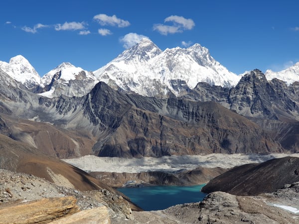
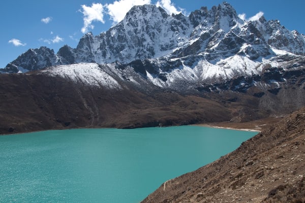
The recommended option is the walk up toward Tsho Rolpa (4,580 m), the great glacial lake at the head of the valley, and back. It gains useful height, and the lake itself is remarkable: it has grown substantially over recent decades as the Trakarding glacier has retreated, and is one of the most closely monitored glacial lakes in Nepal because of the flood risk it poses to the valleys below.
The surrounding peaks — Chekigo, Pachermo and the wall around the Tashi Lapcha — are all visible from the moraine.
This is the final day with any margin for adjustment. From tomorrow the route is on moraine and glacier, camping above 4,800 m, with the pass crossing two days away.
Spend the afternoon resting, checking crampons, harness and layers with your guide, and eating well. Overnight in Na.
9Day 9Trek from Na (4,180 m) to Chyukyoma (4,870 m)
Trek from Na (4,180 m) to Chyukyoma (4,870 m)
A climb of around 690 m onto the moraine, leaving the last settlement behind.
The trail follows the valley east past Tsho Rolpa, traversing the lateral moraine along the lake's northern shore. This is rough, unstable ground — loose rock and boulder on a steep bank above the water — and it requires careful, steady walking.
Beyond the lake the route continues onto the moraine of the Trakarding Glacier. The landscape from here is entirely rock and ice: no vegetation, no shelter, and no trail in any conventional sense, just a route picked between boulders.
The peaks close in around the head of the valley, and the scale is considerable.
Chyukyoma (4,870 m) is a camping spot on the moraine rather than any kind of settlement — a patch of flatter ground among the rubble. It is cold and exposed.
Around 5–6 hours. Overnight camping at Chyukyoma.
10Day 10Trek from Chyukyoma (4,870 m) to Trakarding Glacier (4,850 m)
Trek from Chyukyoma (4,870 m) to Trakarding Glacier (4,850 m)
A day on the glacier itself — slow, technical ground with almost no net height change.
The distance covered is short and the elevation barely alters, but this is one of the harder days of the trek. The route travels along and across the Trakarding Glacier, over a chaotic surface of rubble-covered ice, boulder fields, meltwater channels and crevassed sections.
Progress is necessarily slow. Route-finding matters, the footing is loose and awkward, and the glacier changes from season to season, so the line taken is decided by the guide on the day. Rope may be used on the more broken sections.
The surroundings are extraordinary: an amphitheatre of ice walls and rock faces, with hanging glaciers above and the sound of meltwater and occasional rockfall.
Camp is made on the glacier or its margin at around 4,850 m. This is a serious, committing environment and a cold night.
Around 5–6 hours. Overnight camping on the Trakarding Glacier.
11Day 11Trek from Trakarding Glacier (4,850 m) to Tashi Lapcha Phedi (5,010 m)
Trek from Trakarding Glacier (4,850 m) to Tashi Lapcha Phedi (5,010 m)
A short but demanding day onto the shelf below the pass, gaining around 160 m.
The route continues up the glacier before climbing off it onto steeper ground — the ascent to the Tashi Lapcha shelf involves scrambling on rock and, depending on conditions, fixed rope. This is the point at which the trek becomes unambiguously mountaineering terrain.
The day is deliberately short. The purpose is to be positioned as close to the pass as possible, as rested as possible, for tomorrow's crossing.
Tashi Lapcha Phedi (5,010 m) is an exposed camp beneath the pass, surrounded by ice walls and rock faces, with Pachermo (6,273 m) above. There is no shelter of any kind.
The evening is spent preparing: crampons fitted, harnesses checked, ropes sorted, and an early meal. Sleep is often poor at this altitude, and the start tomorrow is well before dawn.
Around 3–4 hours. Overnight camping at Tashi Lapcha Phedi.
12Day 12Cross Tashi Lapcha Pass (5,755 m) and Trek to Pachermo High Camp / Tashi Puk (5,300 m)
Cross Tashi Lapcha Pass (5,755 m) and Trek to Pachermo High Camp / Tashi Puk (5,300 m)
The crux of the trek: the crossing of the Tashi Lapcha (5,755 m), a glaciated pass linking Rolwaling to the Khumbu.
You start in the dark, roped up and in crampons. The climb from Phedi gains around 750 m on snow and ice, with crevassed sections requiring rope work and careful route-finding. The early start is essential — the snow is firmer before the sun softens it, and afternoon weather on this pass can be severe.
It is slow, cold, serious work at altitude, and the crossing is entirely condition-dependent. Your guide may turn the party around if the weather or snowpack is wrong; this is not a pass to force.
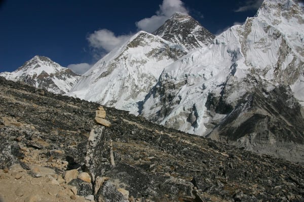
From the top, marked with prayer flags, the view is the reward: back over the Rolwaling glaciers, and east into the Khumbu, with Everest, Lhotse and Cho Oyu among the peaks visible.
The descent leads to Tashi Puk (5,300 m) beneath Pachermo. A long 7–9 hours. Overnight camping at Tashi Puk.
13Day 13Trek from Pachermo High Camp / Tashi Puk (5,300 m) to Thame (3,820 m)
Trek from Pachermo High Camp / Tashi Puk (5,300 m) to Thame (3,820 m)
A long descent of nearly 1,500 m off the glacier and into the inhabited Khumbu.
The morning continues down through moraine and rocky terrain, leaving the glacial environment behind over the course of a few hours. The going is rough underfoot at first, on loose rock and boulder, before the trail becomes a proper path again.
As you lose height the transformation is rapid and welcome: scrub and grass return, then juniper and rhododendron, and there is running water and colour in the landscape after days of rock and ice.
Thame (3,820 m) is the first village on the Khumbu side, and a significant one — it is the home village of several of the most famous Sherpa climbers, including Tenzing Norgay, and its gompa, set high above the settlement, is one of the oldest in the region.
After a week of camping, a lodge, a hot meal and a bed are considerable. Around 6–7 hours. Overnight in Thame.
14Day 14Trek from Thame (3,820 m) to Namche Bazaar (3,440 m)
Trek from Thame (3,820 m) to Namche Bazaar (3,440 m)
An easier day descending around 380 m into the main hub of the Khumbu.
The trail follows the Bhote Koshi valley south-east from Thame, descending gently through juniper and pine and past a string of Sherpa settlements — Thamo, Phurte and Zamphute — with mani walls, chortens and prayer wheels along the way.
The contrast with the past week is striking. Rolwaling was empty; the Khumbu is busy. From here on you are on the main Everest trekking network, and you will meet a steady flow of trekkers heading up toward Base Camp.
Namche Bazaar (3,440 m) is the trading and administrative centre of the Khumbu, a horseshoe of lodges, shops, bakeries and gear stores built into a natural bowl at 3,440 m. There are hot showers, cafés and a Saturday market.
After the Tashi Lapcha, it feels almost like a city. Around 4–5 hours. Overnight in Namche Bazaar.
15Day 15Trek from Namche Bazaar (3,440 m) to Lukla (2,860 m)
Trek from Namche Bazaar (3,440 m) to Lukla (2,860 m)
The final walking day, a long descent down the Dudh Koshi to the airstrip.
The trail drops steeply out of Namche on the switchbacks above the Hillary Suspension Bridge, crossing high above the confluence of the Dudh Koshi and Bhote Koshi, then follows the river downstream.
The route passes through Jorsale, the Sagarmatha National Park checkpoint, and then Monjo and Phakding, crossing the river repeatedly on suspension bridges strung with prayer flags. The valley is forested and green at this altitude, and the walking is pleasant.
The last hour climbs gently to Lukla (2,860 m) — the only significant ascent of the day, and a mildly unwelcome one at the end of a long trek.
Lukla is the end of the journey, and the evening is the natural time for a celebration with the guide and crew who got the party over the Tashi Lapcha.
Around 6–7 hours. Overnight in Lukla.
16Day 16Fly from Lukla (2,860 m) to Kathmandu (1,400 m)
Fly from Lukla (2,860 m) to Kathmandu (1,400 m)
The short and famously dramatic flight from Lukla back to the capital.
Flights from Lukla leave early in the morning, before the wind and cloud build. The Tenzing–Hillary Airport has a single short runway built on a slope against a hillside, and take-off is memorable — the aircraft accelerates downhill and off the end of the shelf into the valley.
The flight to Kathmandu takes around 35 minutes, with excellent views of the Himalaya on the northern side of the aircraft.
It is worth noting that Lukla flights are highly weather-dependent and delays or cancellations are routine. This itinerary includes the return day with that in mind, and the spare time in Kathmandu is a useful buffer.
You arrive in Kathmandu (1,400 m) and transfer to your hotel. The rest of the day is free — a shower, a proper meal, and time to rest. Overnight in Kathmandu.
17Day 17Final Departure from Kathmandu (1,400 m)
Final Departure from Kathmandu (1,400 m)
The last day of the Rolwaling Tashi Lapcha Pass Trek.
Depending on your flight time there may be free hours in the morning for last-minute shopping in Thamel, or a visit to Boudhanath — the centre of Kathmandu's Tibetan Buddhist community, and a fitting close after the gompas of Bedding and Thame.
Our representative collects you from your hotel and transfers you to Tribhuvan International Airport around three hours before departure.
You leave having completed one of the most demanding crossings in Nepal: the length of the remote Rolwaling valley beneath Gaurishankar, the glacial lake at Tsho Rolpa, several days of camping on the Trakarding Glacier, and the roped crossing of the Tashi Lapcha (5,755 m) into the Khumbu — a route that is genuinely closer to mountaineering than to trekking.
Inclusions & Exclusions
Ground transport to Jagat, the Lukla flight home, Kathmandu accommodation, teahouse and tented lodging, all trekking meals, conservation and national park permits, a licensed guide, group climbing equipment, and government taxes are included, while international flights, visa, insurance, personal gear, porter service, city meals, personal expenses, and tips are excluded.
What's Included
Airport pickup and drop-off services in Kathmandu.
Domestic flight from Lukla to Kathmandu at the end of the trek, including airport transfer.
Ground transportation from Kathmandu to Jagat as per the itinerary.
Accommodation in Kathmandu with breakfast.
Accommodation in local teahouses during the trek.
Gaurishankar Conservation Area Permit, Sagarmatha National Park Entry Permit, and Khumbu Pasang Lhamu Rural Municipality Entry Permit.
Professional English-speaking licensed trekking guide.
Three meals a day (breakfast, lunch, and dinner) during the trek.
Group trekking map for route guidance.
First aid kit carried by the guide.
Tented accommodation and a full camp crew for the high-camp sections between Chyukyoma and Tashi Lapcha Phedi.
Group climbing equipment for the Tashi Lapcha Pass crossing, including ropes and fixed line where required.
All government taxes, permit fees, and service charges.
What's Excluded
International flight tickets to and from Nepal.
Nepal entry visa fees.
Travel insurance, including emergency helicopter evacuation coverage.
Personal trekking equipment and clothing.
Porter services (available at an additional cost).
Lunch and dinner in Kathmandu.
Snacks, bottled water, hot showers, Wi-Fi, charging fees, and alcoholic or soft drinks.
Personal expenses such as laundry, phone calls, and souvenirs.
Tips for guides, drivers, and support staff.
Any additional accommodation, transportation, or expenses caused by pass closures, Lukla flight delays, bad weather, or other unforeseen circumstances beyond the itinerary.
Route Map
Explore the terrain map showing the trek route.
Loading map...
Altitude Profile
Pricing
Transparent per-person pricing based on group size, covering the services listed in the itinerary with no hidden charges.
Add-ons
Customize your trek with optional services such as porter support and other personalized arrangements at an additional cost.
Best Time to Trek
The Tashi Lapcha crossing dictates the season. Late April to late May and late September to late October are the two reliable windows, when snow on the pass is consolidated, the glacier is in reasonable condition, and the weather is settled enough to plan a crossing with confidence.
Outside those windows the pass is the deciding factor rather than the trail. Winter snow makes Tashi Lapcha impassable for most groups, and the monsoon brings rockfall, crevasse hazard, and heavy cloud on the glacier sections. We do not operate this itinerary in mid-winter or during the monsoon, and even in season we build in flexibility because a pass closure can require rerouting the second half of the trek.
For a month-by-month look at weather and trail conditions, see our guide to the best time to trek in Nepal.
Trek Difficulty & Experience Required
This is one of the hardest itineraries we run and it is not a route for a first Himalayan trek. The Tashi Lapcha crossing involves glacier travel on snow and ice where a rope, harness, and crampons are used, loose moraine on both approaches, and a very long summit day starting well before dawn. Several nights are spent at basic high camps rather than teahouses.
You should arrive with previous high-altitude trekking experience, ideally including a glaciated pass, and a strong base of endurance fitness built over three to four months. Comfort walking on uneven ground with a pack, competence with crampons, and a genuine tolerance for cold, remoteness, and basic camp conditions all matter here. If you have not trekked above 5,000 m before, we would honestly recommend the Everest Three Pass Trek first.
To see where this trek sits among Nepal's routes, read our guide to Nepal trek difficulty grades.
Travel Insurance
Travel insurance covering trekking and glacier travel to 6,000 m is mandatory, and for this route you will need a specialist adventure or mountaineering policy. Standard travel insurance excludes glacier travel and roped movement outright, so check the activity definitions as carefully as the altitude limit before you buy.
Emergency helicopter evacuation and repatriation cover is non-negotiable. Rolwaling is remote even by Nepali standards — from the high camps around Tashi Lapcha the nearest road is several days' walk and evacuation means a helicopter, which operators dispatch only against a guarantee of payment. Also confirm cover for medical treatment, trip cancellation, and delayed domestic flights on the Lukla sector. Send us your policy number and the insurer's 24-hour emergency line well before departure.
Our guide to travel insurance for trekking in Nepal explains the altitude limits, evacuation terms and common exclusions to check before you buy.
Altitude, Acclimatization & Safety
The itinerary includes acclimatization days at Bedding (3,690 m) and Na (4,180 m), both used for climb-high, sleep-low day hikes into the surrounding basins. This matters more here than on most routes, because from Na the trek climbs steadily to Chyukyoma, the Trakarding Glacier, and Tashi Lapcha Phedi at 5,010 m, with the crossing itself at 5,755 m.
Your guide assesses the group's condition and the pass conditions before committing to the crossing, and there is a genuine possibility of turning back. Because there is no lower ground to retreat to quickly once you are high in the valley, we err firmly on the side of caution. Drink heavily, eat properly even when appetite fades, avoid alcohol from Bedding onward, and report symptoms the evening they appear rather than the following morning.
Prevention, symptoms and treatment are covered in depth in our guide to altitude sickness in Nepal.
Accommodation, Food & Equipment
Lodging alternates between simple village teahouses and lodges in the lower Rolwaling valley — Simigaon, Gyalche, Bedding, and Na — and tented high camps at Chyukyoma, the Trakarding Glacier, and Tashi Lapcha Phedi where no permanent lodging exists. Once you cross into the Khumbu at Thame the trek returns to comfortable Sherpa teahouses through to Lukla.
All meals are included during the trek. In the villages you eat lodge food — dal bhat, noodles, soups, eggs, and potato dishes — while at the high camps our crew cooks for the group. Group technical equipment for the pass, including rope and fixed line where required, is provided; you should bring or rent personal crampons, a harness, and an ice axe, and your guide will confirm the exact list once numbers are known. Water is drawn from streams and glacier melt and must be treated with tablets, a filter, or a UV pen.
What the lodges are really like, from rooms and meals to showers and charging, is covered in our guide to teahouse trekking in Nepal.
Frequently Asked Questions
Find quick answers to common questions about the Rolwaling Valley Trek.
1How many people usually trek in Rolwaling?
Very few. The valley receives a small fraction of the traffic on the Everest or Annapurna trails, and on the Rolwaling side you may not pass another trekking group for days. That solitude is a large part of the appeal and also why the route demands self-sufficiency.
2What happens if the Tashi Lapcha Pass cannot be crossed?
The crossing depends on snow and weather, and there is a real chance in any given season that it is not safe. If your guide judges it unsafe, the group retraces the Rolwaling valley to the road head instead. Your trek does not end, but the Khumbu section is replaced, so build flexibility into your travel plans.
3Do I need mountaineering skills?
You do not need to be a climber, but you do need to be comfortable walking roped on glacier terrain in crampons. Your guide covers technique before the crossing. Prior experience on a glaciated pass makes a substantial difference to how manageable the summit day feels.
4How many hours do we walk each day?
Ordinary days run six to eight hours. The glacier days and the Tashi Lapcha crossing are considerably longer, often ten to twelve hours from a pre-dawn start, on loose moraine and snow.
5Which permits are required and do you arrange them?
You need the Gaurishankar Conservation Area Permit, the Sagarmatha National Park Entry Permit for the Khumbu section, the Khumbu Pasang Lhamu Rural Municipality Permit, and TIMS registration. All are included and arranged by our team from passport copies and photographs sent in advance.
6Is there mobile network on the route?
Coverage is minimal in the Rolwaling valley and absent at the high camps. Expect to be entirely offline from Simigaon until you reach Thame in the Khumbu, where Ncell and NTC service resumes. Our guides carry a satellite communication device for emergencies.
7Where can I get cash, and can I charge devices?
There are no ATMs anywhere on the Rolwaling side; the first are in Namche Bazaar near the end of the trek. Carry all your Nepalese rupees from Kathmandu. Charging is limited to solar power at village lodges and unavailable at high camps, so bring a large power bank and spare batteries.
8How cold does it get at the high camps?
Nights at Tashi Lapcha Phedi and on the glacier regularly fall to -15°C or below, colder with wind. A four-season sleeping bag rated to -20°C, an insulated sleeping mat, and a full down layering system are essential rather than optional on this route.
9How large are the groups and what support is provided?
Groups are kept small and led by a licensed guide with specific Tashi Lapcha experience, supported by climbing staff and a camp crew for the high-camp section. The support ratio is significantly higher than on a teahouse trek because of the camping and glacier days.
10Can I leave extra luggage in Kathmandu?
Yes. Your Kathmandu hotel stores anything you do not need on the trail free of charge until you return, which is worth using given how carefully weight has to be managed on this itinerary.
Gallery
Explore authentic moments, landscapes, and mountain views from the Rolwaling Valley Trek.
Trekking Guides & Articles
Rolwaling Valley and the Tashi Lapcha: Nepal's Hidden Valley — A valley between Everest and Langtang with Gaurishankar above it, the Tsho Rolpa glacial lake, and a 5,755 m pass crossing into the Khumbu.
Tsho Rolpa Trek: The Complete Guide to Rolwaling's Glacial Lake — Twelve days up the Rolwaling valley — the hidden valley of Sherpa legend — to the largest glacial lake in Nepal.
Pachermo Peak Climbing: The Complete Guide — A traverse rather than an out-and-back — in through the Rolwaling gorge, up the peak, then over the Tashi Lapcha into the Khumbu.
Fix Departure
This trek runs every week on the selected day. Choose custom dates for one-off departures.
Showing fixed departures in Oct 2026
Guest Reviews
Five stars is not enough
“We picked Rolwaling Valley Trek after a lot of research and it did not disappoint. The itinerary was well paced with proper acclimatisation days built in. Our porter carried our bags without complaint...
Gustav Garcia
Get in Touch
Tell us the dates you have in mind and roughly what you want out of the trek — one of our guides will reply, usually within 24 hours.
Email Us
info@greencompasstreks.com
Call Us
+977 9864379436
Office
Lakeside, Pokhara, Nepal
Office Hours
Sunday – Friday, 9:00 AM – 9:00 PM
Similar Treks
You might also like these treks
Porter
$578 $525/porter
No payment required yet