

Annapurna Circuit Trek
The Annapurna Circuit Trek is the classic Himalayan traverse and still one of the most varied long treks in the world. O
Porter
$462 $420/porter
Flight from Pokhara to Kathmandu
$127 $115/person
No payment required yet
Trip Overview
The Annapurna Circuit Trek is the classic Himalayan traverse and still one of the most varied long treks in the world. Over 15 days the route works up the Marsyangdi valley from Tal through Chame and Upper Pisang to Manang (3,540 m), crossing from green terraced hillsides and pine forest into the dry, Tibetan-influenced high country north of the Annapurna massif.
This itinerary adds the spectacular detour to Tilicho Lake (4,919 m), one of the highest lakes on earth, before rejoining the main trail for the crossing of Thorong La Pass (5,416 m) and the descent to the pilgrimage temple complex at Muktinath. Few treks pack this much variety into one route: subtropical valleys, alpine meadows, an acclimatization day in Manang, a turquoise high lake, a legendary pass, and the arid moonscape of Mustang on the far side.
Trip Highlights
Cross Thorong La Pass (5,416 m): Complete the Annapurna Circuit's legendary crossing, the highest point of the trek and one of the great walking passes in Nepal.
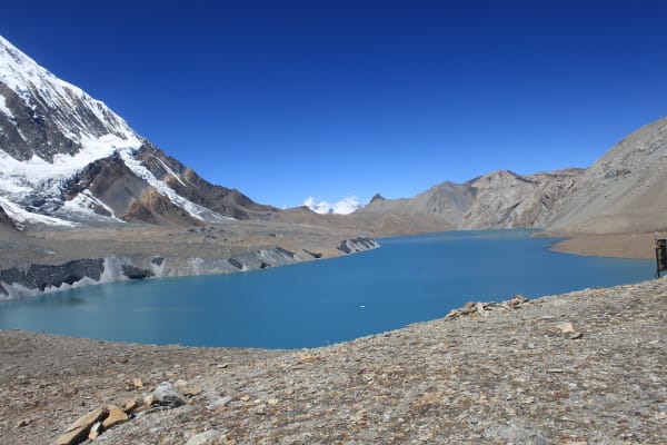
Tilicho Lake (4,919 m): Detour to one of the highest lakes in the world, set in a stark glacial basin beneath Tilicho Peak.
Acclimatization Day in Manang: Rest in the largest village on the circuit, with its gompas, viewpoints, and altitude briefings before the high sections.
The Muktinath Temple Complex: Descend from the pass to the sacred site revered by both Hindus and Buddhists, with its 108 water spouts and eternal flame.
From Rice Terraces to High Desert: Watch the landscape change completely as you cross from the green Marsyangdi valley into the arid rain shadow of Mustang.
Itinerary
A 15-day Annapurna Circuit with an acclimatization day in Manang, the Tilicho Lake detour at 4,919 m, and the Thorong La Pass crossing at 5,416 m.
1Day 1Arrival in Kathmandu (1,400 m)
Arrival in Kathmandu (1,400 m)
You land at Tribhuvan International Airport in Kathmandu (1,400 m) and are met by our representative for the transfer to your hotel in Thamel, the old trekking quarter of the city.
Your guide joins you for the pre-trek briefing. The Annapurna Circuit is a long, high route with a serious pass at its centre, so the briefing matters: we go through the daily distances, the acclimatisation plan at Manang, the Tilicho Lake detour, and above all the crossing of Thorong La (5,416 m) — the highest point of the trek and one of the highest trekking passes in the world. Your guide will explain how we monitor for altitude sickness and what the turnaround criteria are.
Kit is checked against the list. A properly warm down jacket, insulated gloves, a four-season sleeping bag and broken-in boots are essential for the pass; anything missing can be bought or hired in Thamel. The rest of the day is free. Overnight in Kathmandu.
2Day 2Drive from Kathmandu (1,400 m) to Tal Village (1,700 m)
Drive from Kathmandu (1,400 m) to Tal Village (1,700 m)
A long day on the road. We leave Kathmandu early on the Prithvi Highway, then turn north at Dumre toward Besisahar (830 m), the traditional starting point of the circuit. From Besisahar the sealed road ends and we transfer to a local jeep.
The track up the Marsyangdi valley is rough, narrow and spectacular, cut into the side of a gorge with the river far below and waterfalls dropping across the road in places. It climbs past Bhulbhule, Ngadi and Jagat, gaining height steadily as the valley walls close in.
Tal (1,700 m) is reached in the late afternoon. The name means 'lake', and the village sits on a flat sandy bed where the valley opens briefly — a genuinely striking spot with a waterfall at one end and cliffs on both sides. This is the entrance to the Manang district and the point where the trek proper begins. Overnight in a teahouse at Tal.
3Day 3Trek from Tal (1,700 m) to Danakyu (2,300 m)
Trek from Tal (1,700 m) to Danakyu (2,300 m)
The first day of walking, and an easy introduction. From Tal the trail follows the Marsyangdi upstream, crossing the river on suspension bridges and climbing through a narrow, steep-sided section of gorge.
The route passes through Dharapani (1,860 m), where the Manaslu Circuit trail comes in from the east over the Larkya La — you may meet trekkers finishing that far harder route here. There is a permit checkpoint at Dharapani, and the trail then enters the Manang valley proper.
Beyond Dharapani the vegetation changes noticeably as you climb, from subtropical scrub into pine and blue fir. The trail continues through Bagarchhap, with its whitewashed Tibetan-style gompa, and reaches Danakyu (2,300 m). On a clear afternoon you get the first real mountain views of the trek, with Manaslu behind you and the Annapurna wall beginning to show ahead. Overnight in Danakyu.
4Day 4Trek from Danakyu (2,300 m) to Chame (2,670 m)
Trek from Danakyu (2,300 m) to Chame (2,670 m)
A steady climbing day through forest. The trail leaves Danakyu and ascends through pine and rhododendron toward Timang, a village on a shelf with an exceptional head-on view of Manaslu (8,163 m) — the eighth-highest mountain in the world — rising behind you to the east.
From Timang the path contours through thick pine forest, staying high above the Marsyangdi. The air is cooler and drier now, the smell of resin is everywhere, and the settlements begin to look distinctly Tibetan: flat-roofed stone houses, mani walls, and prayer flags on every ridge.
The trail passes through Thanchok and Koto before reaching Chame (2,670 m), the administrative headquarters of the Manang district. Chame is a substantial town by trekking standards, with shops, a bank, a police checkpoint and — best of all — small hot springs beside the river. There is a first clear view of Lamjung Himal from here. Overnight in Chame.
5Day 5Trek from Chame (2,670 m) to Upper Pisang (3,300 m)
Trek from Chame (2,670 m) to Upper Pisang (3,300 m)
One of the most dramatic days on the circuit. The trail leaves Chame through pine forest and enters a steep, narrow section of the valley where the walls rise almost vertically on both sides.
The highlight comes at Dhukur Pokhari: the Paungda Danda, an immense curved slab of rock sweeping more than 1,500 m up from the riverbed in a single unbroken sheet. It is one of the largest rock faces in the Himalaya and it dominates the whole afternoon's walking.
Beyond it the valley opens out and the landscape changes character completely — drier, browner, and much more Tibetan in feel as you cross into the rain shadow. The trail climbs to Upper Pisang (3,300 m), a medieval-looking village of stacked stone houses on the hillside with an old gompa above it. It is worth the extra climb over Lower Pisang: the view across to Annapurna II and Annapurna IV from the rooftops is superb. Overnight in Upper Pisang.
6Day 6Trek from Upper Pisang (3,300 m) to Manang (3,540 m)
Trek from Upper Pisang (3,300 m) to Manang (3,540 m)
There are two routes today, and we take the high one. The upper trail via Ghyaru and Ngawal climbs about 400 m more than the valley-floor route, but it is far better for both views and acclimatisation — climbing high and dropping back to sleep is exactly what you want at this stage.
The climb to Ghyaru is a steep zigzag, and it is hard work at 3,700 m. From the top the reward is a continuous, uninterrupted panorama of the Annapurna range across the valley: Annapurna II (7,937 m), Annapurna III, Annapurna IV, Gangapurna and Tilicho Peak, with the Marsyangdi a thin line far below. Ghyaru and Ngawal are both old Tibetan settlements with flat roofs stacked with firewood and chortens at every entrance.
The trail then descends gradually to rejoin the main route and reaches Manang (3,540 m), the largest village on the circuit. Overnight in Manang.
7Day 7Acclimatization and Exploration Day in Manang (3,540 m)
Acclimatization and Exploration Day in Manang (3,540 m)
A rest day in Manang, and an essential one. From here the route stays above 3,500 m until the pass, so this day is what makes the Thorong La crossing safe. It is a rest day in name only — we still climb.
There are several options. The walk up to the Gangapurna Lake and the viewpoint above it gains around 300 m and gives a close view of the Gangapurna Glacier calving into the water. Alternatively the climb to Praken Gompa, a small monastery clinging to the cliff above the village at about 3,950 m, is steeper and higher, and the elderly lama there gives blessings to trekkers heading for the pass.
Manang itself is worth time: a compact Tibetan-style village of flat-roofed stone houses, with bakeries, gear shops and a cinema hall. The Himalayan Rescue Association runs a free daily talk on altitude sickness here at 3 pm — genuinely worth attending before you go higher. Overnight in Manang.
8Day 8Trek from Manang (3,540 m) to Tilicho Base Camp (4,150 m)
Trek from Manang (3,540 m) to Tilicho Base Camp (4,150 m)
Today we leave the main circuit for the Tilicho Lake detour — an addition that turns a good trek into an exceptional one. The trail heads west from Manang up the Khangsar Khola valley, climbing gradually through Khangsar, the last village on this side.
Beyond Khangsar the landscape becomes genuinely high and arid: no trees, sparse scrub, and enormous scree slopes. The trail passes an old gompa and climbs to Shree Kharka (4,050 m) before the section the route is known for — the landslide traverse, a long path cut across steep, unstable scree slopes with a considerable drop below. It is not technical and there is no exposure to climbing, but it demands concentration and steady footing, and your guide will set the pace.
Tilicho Base Camp (4,150 m) is a small group of lodges in a bare amphitheatre of rock. It is cold and basic, and at this altitude sleep can be broken. Eat well and hydrate. Overnight at Tilicho Base Camp.
9Day 9Early Morning Hike from Tilicho Base Camp (4,150 m) to Tilicho Lake (4,919 m) and Trek to Shree Kharka (4,050 m)
Early Morning Hike from Tilicho Base Camp (4,150 m) to Tilicho Lake (4,919 m) and Trek to Shree Kharka (4,050 m)
A pre-dawn start, usually around 4:00 am, for the climb to the lake. The trail zigzags up a long series of switchbacks on open scree — nearly 800 m of ascent with no shelter and no water, in cold that bites hard before sunrise. It is the hardest sustained climb of the trek so far.
Tilicho Lake (4,919 m) is one of the highest lakes of its size anywhere on earth. It sits in a stark, treeless basin below Tilicho Peak, its surface frozen for much of the year and an extraordinary opaque turquoise when it is not. There is no vegetation, no birdsong and very little wind noise — the silence at the lake is something most trekkers remember longer than the view.
After time at the lake we descend the switchbacks back to base camp for a late breakfast, then recross the landslide section to Shree Kharka (4,050 m). Sleeping lower than you climbed is good practice. Overnight at Shree Kharka.
10Day 10Trek from Shree Kharka (4,050 m) to Yak Kharka (4,050 m)
Trek from Shree Kharka (4,050 m) to Yak Kharka (4,050 m)
A shorter, gentler day, and a deliberate one — after Tilicho the body needs a lighter stage before the pass. The trail contours back east, rejoining the main circuit route above Manang without losing much height.
The walking is across open, high pasture with wide views back to Gangapurna and the Annapurna wall. This is grazing country, and you will pass yak herds, stone-walled corrals and the summer huts of Manang herders. Watch the slopes for blue sheep, which are common here and often visible in groups of twenty or more, and for Himalayan griffon vultures riding the thermals above the valley.
Yak Kharka (4,050 m) is a small cluster of lodges on an open shelf. There are no trees at this height, the wind picks up in the afternoon, and the nights are properly cold. Keep drinking, eat a full dinner and rest — the pass is now two days away. Overnight at Yak Kharka.
11Day 11Trek from Yak Kharka (4,050 m) to Thorong Phedi (4,450 m)
Trek from Yak Kharka (4,050 m) to Thorong Phedi (4,450 m)
A short day by distance but a significant one by altitude. The trail climbs gradually from Yak Kharka along the side of the valley to Ledar, then traverses a steep and slightly exposed section above the Jarsang Khola where the path is cut into loose slope.
There is a bridge crossing and then a final climb to Thorong Phedi (4,450 m) — 'phedi' simply means 'foot of the hill', and that is exactly what it is: two lodges tucked into a bowl directly beneath the wall you will climb tomorrow.
The afternoon is deliberately unstructured. Trekkers who are feeling strong often walk up toward High Camp (4,880 m) and come back down, which helps acclimatisation. Otherwise rest, drink constantly, and eat as much as you can manage — appetite fades at this height, but tomorrow needs fuel. Your guide will check everyone's condition this evening and make the call on the crossing. Sleep early; the start is around 4:00 am. Overnight at Thorong Phedi.
12Day 12Trek from Thorong Phedi (4,450 m) to Muktinath (3,800 m) via Thorong La Pass (5,416 m)
Trek from Thorong Phedi (4,450 m) to Muktinath (3,800 m) via Thorong La Pass (5,416 m)
The big day. We start around 4:00 am by head torch, because the wind on the pass rises sharply through the morning and is often unmanageable by midday. The first hour is the steepest of the whole trek, climbing the wall above Phedi to High Camp (4,880 m) in the dark.
From High Camp the gradient eases but the altitude does the work instead. The trail crosses a series of false summits over snow and frozen scree — each one looks like the top and is not — for three to four hours. Progress is slow by design; the pace is a steady plod, and stopping to breathe is normal. Sunrise on the way up lights Chulu and the Annapurnas behind you.
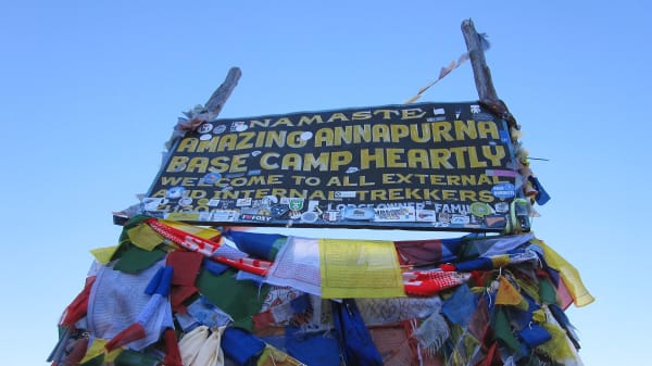
Thorong La (5,416 m) is marked by a cairn buried in prayer flags and a small tea shack. Then comes the descent — 1,600 m of it, long and hard on the knees, dropping into the Kali Gandaki valley with the brown hills of Mustang and the wall of Dhaulagiri (8,167 m) ahead. Muktinath (3,800 m) is a major pilgrimage site sacred to both Hindus and Buddhists, with 108 water spouts and an eternal natural flame. Overnight in Muktinath.
13Day 13Drive from Muktinath (3,800 m) to Pokhara (822 m)
Drive from Muktinath (3,800 m) to Pokhara (822 m)
Before leaving, most trekkers visit the Muktinath Temple complex, one of the most important pilgrimage sites in the Himalaya. Hindus know it as Mukti Kshetra, the place of liberation; Buddhists as Chumig Gyatsa, the hundred waters. Pilgrims bathe under all 108 spouts in the cold morning air.
We then begin the long drive down the Kali Gandaki — the deepest gorge in the world, running between the eight-thousand-metre massifs of Dhaulagiri and Annapurna. The road passes through Kagbeni (2,800 m) at the gateway to Upper Mustang, then Jomsom (2,700 m), the apple-growing village of Marpha (2,670 m), and Tatopani with its hot springs.
The landscape transforms completely over the course of the day: from bare high desert, through pine forest, into the subtropical green of the middle hills. It is a long drive on rough road for much of it, arriving in Pokhara (822 m) in the evening. Overnight in Pokhara.
14Day 14Drive from Pokhara (822 m) to Kathmandu (1,400 m)
Drive from Pokhara (822 m) to Kathmandu (1,400 m)
A relaxed morning in Pokhara. If you wake early, the sunrise over the Annapurna range from the lakeside is worth it — you have just walked around the far side of that skyline. A boat on Phewa Lake or a walk up to the World Peace Pagoda are both easy pre-breakfast options.
We then drive east on the Prithvi Highway back to Kathmandu (1,400 m), following the Marsyangdi and Trishuli rivers. There is a certain symmetry to it: this is the same river valley you drove up two weeks ago on the way to Besisahar, seen from the other end of the trek.
It is a full day on the road with a lunch stop, arriving in the capital in the late afternoon. After transferring to your hotel the evening is free for a shower, a good meal and last-minute shopping in Thamel. Overnight in Kathmandu.
15Day 15Departure from Kathmandu (1,400 m)
Departure from Kathmandu (1,400 m)
Your final day in Nepal. If your flight is later in the day, there is time for one more part of the Kathmandu Valley — Boudhanath Stupa, Pashupatinath Temple and Swayambhunath are all within a short drive and all worth an hour.
Our representative will collect you from your hotel and transfer you to Tribhuvan International Airport around three hours before your scheduled departure.
The Annapurna Circuit is one of the great long-distance walks. In fifteen days you have crossed from the wet, green Marsyangdi gorge to the high desert of Mustang, stood beside Tilicho Lake at 4,919 m, crossed Thorong La at 5,416 m, and walked the deepest gorge on earth. If you would like to go back to the Annapurnas from a different direction, the Sanctuary route to base camp and the Upper Mustang trek both make natural sequels. Safe travels.
Inclusions & Exclusions
Jeep and tourist bus transport as per the itinerary, Kathmandu and Pokhara accommodation, teahouse lodging, all trekking meals, conservation area permits, a licensed guide, trekking map, first aid, and government taxes are included, while international flights, visa, insurance, personal gear, porter service, city meals, personal expenses, and tips are excluded.
What's Included
Airport pickup and drop-off services in Kathmandu.
Private jeep transportation from Kathmandu to Tal Village as per the itinerary.
Shared jeep transportation from Muktinath to Pokhara.
Tourist bus transportation from Pokhara to Kathmandu.
Accommodation in Kathmandu with breakfast.
Accommodation in Pokhara with breakfast.
Accommodation in local teahouses during the trek.
Annapurna Conservation Area Permit (ACAP) and required trekking permits.
Professional English-speaking licensed trekking guide.
Three meals a day (breakfast, lunch, and dinner) during the trek.
Group trekking map for route guidance.
First aid kit carried by the guide.
All government taxes, permit fees, and service charges.
What's Excluded
International flight tickets to and from Nepal.
Nepal entry visa fees.
Travel insurance, including emergency helicopter evacuation coverage.
Personal trekking equipment and clothing.
Porter services (available at an additional cost).
Lunch and dinner in Kathmandu and Pokhara.
Snacks, bottled water, hot showers, Wi-Fi, charging fees, and alcoholic or soft drinks.
Personal expenses such as laundry, phone calls, and souvenirs.
Tips for guides, drivers, and support staff.
Any additional accommodation, transportation, or expenses caused by unforeseen circumstances beyond the itinerary.
Route Map
Explore the terrain map showing the trek route.
Loading map...
Altitude Profile
Pricing
Transparent per-person pricing based on group size, covering the services listed in the itinerary with no hidden charges.
Add-ons
Customize your trek with optional services such as porter support and other personalized arrangements at an additional cost.
Best Time to Trek
March to May and September to November are the two reliable seasons, and Thorong La is what decides it. Autumn offers the most settled weather and the highest chance of a straightforward pass day, which is why it is the busiest period on the circuit. Spring is warmer, the lower valleys are green and flowering, and the Tilicho basin is at its most striking.
Winter snow regularly closes Thorong La and the Tilicho Base Camp approach for days at a time, and many high lodges shut, so December to February is only for trekkers prepared to be turned back. The monsoon brings landslides on the lower Marsyangdi road sections and cloud that hides the range, though the Manang side sits partly in the rain shadow and stays drier than most of Nepal.
For a month-by-month look at weather and trail conditions, see our guide to the best time to trek in Nepal.
Altitude & Acclimatization
The itinerary includes a dedicated acclimatization day at Manang (3,540 m) and then approaches Thorong La by way of Tilicho Base Camp, Shree Kharka, Yak Kharka, and Thorong Phedi, which gives an unusually generous adaptation profile compared with the standard circuit. The Tilicho Lake day hike itself works as a climb-high, sleep-low exercise, gaining almost 800 m before returning to lower ground.
Thorong La is crossed from Thorong Phedi with a very early start, typically around four in the morning, to reach the pass before the afternoon wind. Your guide monitors the group each evening for headache, poor sleep, appetite loss, and breathlessness at rest, and will hold the group at Manang or Yak Kharka for an extra day if anyone is not adapting. Drink three to four litres a day, walk at a conversational pace, and skip alcohol from Manang onward.
Prevention, symptoms and treatment are covered in depth in our guide to altitude sickness in Nepal.
Travel Insurance
Travel insurance covering trekking to at least 6,000 m is mandatory for this itinerary, because Thorong La stands at 5,416 m and the Tilicho Lake hike reaches 4,919 m. Most standard policies cap well below this and would leave you uninsured for the defining sections of the trek, so read the altitude clause carefully rather than assuming.
The essential clause is emergency helicopter evacuation and repatriation. Between Manang and Muktinath there is no reliable road access and a serious altitude problem near the pass is resolved by helicopter, which operators dispatch only against a guarantee of payment. Also check cover for medical treatment and trip cancellation. Please send us your policy number and the insurer's 24-hour emergency line before departure.
Our guide to travel insurance for trekking in Nepal explains the altitude limits, evacuation terms and common exclusions to check before you buy.
Packing List
The circuit spans everything from warm subtropical valleys to a sub-zero pass crossing, so a full layering system is essential. Bring broken-in waterproof trekking boots, three or four base layers, a fleece, an insulated down jacket, a waterproof shell jacket and trousers, trekking trousers, a warm hat, sun hat, liner and insulated gloves, and several pairs of wool socks. A sleeping bag rated to -15°C is appropriate for Thorong Phedi and Tilicho Base Camp.
Also pack a 30-40 litre daypack, trekking poles (invaluable on the long descent from the pass to Muktinath), a headlamp with spare batteries for the pre-dawn start, high-SPF sunscreen and lip balm, category 3 or 4 sunglasses, a reusable bottle with purification tablets or a filter, a personal first aid kit, quick-dry towel, toiletries, and a power bank. Microspikes are worth renting in Manang if there has been recent snow. Keep your porter-carried duffel under 15 kg.
For the complete kit list, organised by the altitude you will reach, see our Nepal trekking packing list.
Accommodation, Food & Drinking Water
You stay in a tourist-standard hotel in Kathmandu and Pokhara at either end and in teahouses throughout the trek. Lodges on the Annapurna Circuit are among the best in Nepal — Chame, Manang, and Muktinath all have comfortable rooms, hot showers, bakeries, and even coffee shops. Tilicho Base Camp and Thorong Phedi are the exceptions, offering basic dormitory-style or simple twin rooms with shared toilets and heating only in the dining room.
Three meals a day are included on the trek. Breakfast is porridge, eggs, Tibetan bread, or pancakes; lunch and dinner come from the lodge menu, with dal bhat and its unlimited refills the best value alongside noodles, fried rice, momos, soups, pizza, and pasta. Manang in particular has a surprisingly broad choice for its altitude. Refill your bottle at lodges or safe drinking water stations along the route and treat it with tablets, a filter, or a UV pen rather than buying plastic bottles.
What the lodges are really like, from rooms and meals to showers and charging, is covered in our guide to teahouse trekking in Nepal.
Frequently Asked Questions
Find quick answers to common questions about the Annapurna Circuit Trek.
1How difficult is the Annapurna Circuit Trek?
It is moderate for most of its length and challenging on the Tilicho and Thorong La sections. There is no technical ground, but the pass day involves roughly seven to nine hours of walking with a 1,000 m climb and a 1,600 m descent at high altitude, which is the hardest single day on the trek.
2How many hours do we walk each day?
Typically five to seven hours. The Tilicho Lake day and the Thorong La crossing are the longest, at eight to ten hours each, and both start before dawn to make use of stable morning conditions.
3Which permits are required and do you arrange them?
You need the Annapurna Conservation Area Permit and trekking registration. Both are included in your package and arranged by our team from passport copies and passport-sized photographs supplied before departure.
4What happens if Thorong La is closed by snow?
If the pass is unsafe, the group waits at Manang or Yak Kharka for conditions to improve, or retraces the Marsyangdi valley and drives round to Muktinath and Pokhara. Your guide makes that call with local lodge owners and the trekking post, and safety takes precedence over completing the circuit.
5Has the new road spoiled the circuit?
Roads now reach parts of the Marsyangdi and Kali Gandaki valleys, which is why this itinerary drives directly to Tal and out from Muktinath. The walking sections between Tal and Muktinath, including Tilicho and the pass, remain on trail rather than road for almost their entire length.
6Is mobile network and Wi-Fi available?
Coverage is good in Chame, Manang, and Muktinath and patchy in between, with no signal at Tilicho Base Camp or on the pass. Most lodges sell Wi-Fi access, though speeds are slow and the connection drops in bad weather.
7Can I charge my devices and are ATMs available?
Lodges offer charging for a small fee that rises with altitude. There are ATMs in Chame and Manang, but they run out of cash and go offline without warning, so carry enough Nepalese rupees from Kathmandu or Pokhara for the whole trek.
8How cold does it get at night?
Thorong Phedi and Tilicho Base Camp regularly drop to between -10°C and -20°C in the main seasons, and the pre-dawn start on the pass is colder still with wind chill. Lower villages such as Chame and Manang are far milder. A -15°C bag plus a liner is the right specification.
9How large are the groups and who leads the trek?
Groups are capped at twelve trekkers and led by a licensed English-speaking guide from the Annapurna region. We add an assistant guide for larger groups so the party can split by pace on the long pass and Tilicho days.
10Can I leave extra luggage in Kathmandu?
Yes. Your Kathmandu hotel stores anything you do not need on the trail free of charge until you return, so you can travel with trekking kit only and leave city clothes and valuables behind.
Gallery
Explore authentic moments, landscapes, and mountain views from the Annapurna Circuit Trek.
Trekking Guides & Articles
Annapurna Circuit Trek: The Complete Guide — One of the great walks of the world: a circuit from subtropical valleys over the 5,416 m Thorong La into Tibetan-Buddhist high desert.
Crossing Thorong La: The Biggest Day on the Annapurna Circuit — A 4 a.m.
Has the Road Ruined the Annapurna Circuit? An Honest Answer — Roads now reach Manang and Muktinath, and the old Annapurna Circuit is not what it was.
Diamox for Trekking in Nepal: When to Start, Dose and Side Effects — Diamox is the most discussed tablet on any Nepal trek, and the most misunderstood.
Manaslu Circuit Alternatives for Autumn 2026: Where to Trek While the Budhi Gandaki Is Cut — The flood of 11 October 2026 has cut the way into the Manaslu Circuit at the height of the season.
Nar Phu Valley Trek: Two Medieval Villages Behind the Annapurnas — A restricted valley north of Manang holding two of the most isolated Tibetan-Buddhist villages in Nepal, reached through a slot canyon and left over the 5,320 m Kang La.
Fix Departure
This trek runs every week on the selected day. Choose custom dates for one-off departures.
Showing fixed departures in Oct 2026
Guest Reviews
An experience to treasure
“I have done a few Himalayan treks and this one stands out for all the right reasons. Our guide was fantastic — knowledgeable about the mountains, the culture and exactly when we needed a break. Alread...
Cameron Williams
Get in Touch
Tell us the dates you have in mind and roughly what you want out of the trek — one of our guides will reply, usually within 24 hours.
Email Us
info@greencompasstreks.com
Call Us
+977 9864379436
Office
Lakeside, Pokhara, Nepal
Office Hours
Sunday – Friday, 9:00 AM – 9:00 PM
Similar Treks
You might also like these treks


Porter
$462 $420/porter
Flight from Pokhara to Kathmandu
$127 $115/person
No payment required yet