

Tsum Valley and Manaslu Circuit Trek
The Tsum Valley and Manaslu Circuit Trek is a 20-day route through the Manaslu Conservation Area that joins two restrict
Porter
$693 $630/porter
Private Jeep from Kathmandu to Machha Khola
$275 $250/jeep
Private Jeep from Dharapani to Kathmandu
$330 $300/jeep
No payment required yet
Trip Overview
The Tsum Valley and Manaslu Circuit Trek is a 20-day route through the Manaslu Conservation Area that joins two restricted regions into one journey: the hidden Buddhist valley of Tsum and the full circuit of Manaslu (8,163 m), the eighth-highest mountain in the world.
The trek follows the Budhi Gandaki upstream from Machha Khola (930 m) through steep river gorges and suspension bridges before branching east into Tsum Valley. Closed to outsiders until 2008, Tsum is a sacred valley of Tibetan Buddhist settlements, chortens and mani walls, where hunting has been forbidden by local vow for generations. The route reaches Mu Gompa (3,700 m) near the Tibetan border and the nunnery at Rachen Gompa before rejoining the main circuit.
From there the trail climbs through Namrung, Lho and Shyala to Sama Gaun (3,530 m), with an acclimatisation day for the walk up to Manaslu Base Camp or the glacial Birendra Lake. The crux is the crossing of Larkya La Pass (5,106 m) — a long, cold, pre-dawn start over moraine and snow, with the descent to Bimthang (3,720 m) among the finest mountain days in Nepal.
This is a demanding trek. It requires a restricted-area permit, a licensed guide and a minimum group size, and it involves consecutive days above 3,500 m and one serious pass. In exchange it offers far fewer trekkers than the Annapurna or Everest regions, teahouse accommodation throughout, and a route that circles an eight-thousander from river gorge to glacier and back.
Trip Higlights
Explore the Remote Tsum Valley: Trek through secluded Himalayan villages, ancient monasteries, peaceful landscapes, and rich Tibetan Buddhist culture.
Visit Mu Gompa (3,700 m): Discover one of the highest and most important monasteries in Tsum Valley, surrounded by spectacular mountain scenery.
Cross the Challenging Larkya La Pass (5,106 m): Conquer the highest point of the Manaslu Circuit while enjoying breathtaking views of glaciers and snow-covered Himalayan peaks.
Visit Manaslu Base Camp (4,800+ m): Hike from Sama Gaun toward Manaslu Base Camp and experience stunning views of glaciers and the Manaslu massif.
Experience Himalayan Culture and Landscapes: Trek through traditional villages, Buddhist settlements, lush forests, deep valleys, and rugged alpine terrain while experiencing authentic mountain life.
Itinerary
This 20-day itinerary combines the remote Tsum Valley Trek with the scenic Manaslu Circuit Trek, featuring traditional villages, Mu Gompa, Manaslu Base Camp, and the challenging Larkya La Pass (5,106 m)
1Day 1Arrival in Kathmandu (1,400 m)
Arrival in Kathmandu (1,400 m)
You arrive at Tribhuvan International Airport in Kathmandu (1,400 m) and are met by our representative for the transfer to your hotel.
Your guide runs the pre-trek briefing. This itinerary combines two restricted areas in one journey: the sacred Tsum Valley, a hidden side valley on the Tibetan border with a distinct Buddhist culture, and the full Manaslu Circuit around the world's eighth-highest mountain, crossing the Larkya La (5,106 m).
Both sections require restricted-area permits, a registered agency and a minimum of two trekkers with a licensed guide. Independent trekking is not allowed.
This is a long and committing route with a high pass at the end, so acclimatisation is built into the schedule. Your guide checks your equipment — a four-season sleeping bag and proper cold-weather layers are essential for the pass.
The rest of the day is free. Overnight in Kathmandu.
2Day 2Drive from Kathmandu (1,400 m) to Maccha Khola (930 m)
Drive from Kathmandu (1,400 m) to Maccha Khola (930 m)
A long travel day west and then north into the Budhi Gandaki valley.
The morning follows the Prithvi Highway west out of Kathmandu alongside the Trishuli River, before turning north at Dhading toward Arughat. The first half is on sealed road; the second is not.
From Arughat the route continues on a rough, unsealed track up the Budhi Gandaki valley — narrow, dusty and slow, cut into steep hillsides above the river, with several water crossings. A 4WD is essential and the going is bumpy for hours.
The valley is subtropical at this altitude: banana palms, terraced rice and dense green hillsides, with the river running grey and fast below.
Maccha Khola (930 m) — the name means "fish river" — is a small settlement on the riverbank. Around 8–9 hours in total. Overnight at Maccha Khola.
3Day 3Trek from Maccha Khola (930 m) to Jagat (1,340 m)
Trek from Maccha Khola (930 m) to Jagat (1,340 m)
The first walking day, following the Budhi Gandaki upstream through a steep-sided gorge.
The trail runs north beside the river, and although the net gain is only around 400 m, the day involves constant climbing and descending as the path traverses the gorge wall and drops back to the water.
The route crosses several suspension bridges and passes waterfalls coming off the cliffs. A highlight is the hot spring at Tatopani, a short way along the trail, where warm water emerges beside the river.
The terrain is genuinely rugged in places — sections of the path are cut into the rock face or carried on wooden galleries above the water — and landslide damage is common in this steep, wet country.
Jagat (1,340 m) is a neat, attractive village of stone-paved streets and slate-roofed houses, and it is also the entry checkpoint for the Manaslu restricted area.
Around 6 hours. Overnight in Jagat.
4Day 4Trek from Jagat (1,340 m) to Lokpa (2,240 m)
Trek from Jagat (1,340 m) to Lokpa (2,240 m)
A climb of around 900 m to the gateway of the Tsum Valley.
The trail continues north up the Budhi Gandaki, which narrows further into a dramatic gorge with sheer walls on both sides. The route crosses the river repeatedly on suspension bridges and climbs steeply in sections.
You pass Philim, a substantial Gurung village on a terraced hillside, and then the valley divides. The main Manaslu Circuit continues north-west; you turn north-east into the Tsum Valley, and the traffic drops away immediately.
The climb into Tsum is steep and sustained, through bamboo and pine forest with the gorge dropping away below.
Lokpa (2,240 m) is the first village of the Tsum Valley and its gateway — a handful of houses on a shelf high above the river, with the first views of Ganesh Himal and Himalchuli.
Around 6 hours. Overnight in Lokpa.
5Day 5Trek from Lokpa (2,240 m) to Chumling (2,386 m)
Trek from Lokpa (2,240 m) to Chumling (2,386 m)
A day of steep ups and downs deeper into the Tsum Valley, with modest net gain.
The trail descends sharply from Lokpa to the Shiar Khola, then climbs steeply up the far side — the profile is far more demanding than the 150 m net figure suggests.
The walking is through pine and rhododendron forest on steep valley sides, with the river far below and waterfalls coming off the cliffs. As you climb, the views open toward Ganesh Himal and Baudha Himal.
Tsum — from the Tibetan tsombo, meaning vivid — is regarded as a beyul, a sacred hidden valley, and the culture is strongly Tibetan Buddhist. Killing animals is traditionally prohibited throughout the valley, and the practice is still largely observed.
Chumling (2,386 m) is a traditional village of stone houses with a gompa, chortens and mani walls. Around 5 hours. Overnight in Chumling.
6Day 6Trek from Chumling (2,386 m) to Chekampar / Chokhangparo (3,031 m)
Trek from Chumling (2,386 m) to Chekampar / Chokhangparo (3,031 m)
A climb of around 650 m into the upper Tsum Valley, where the country opens out.
The trail crosses the Shiar Khola and climbs steadily through forest that thins as you gain height. At around 2,800 m the valley suddenly broadens into a wide, open, U-shaped basin — the classic upper Tsum landscape — with cultivated terraces and a very different feel from the gorge below.
The views from here are excellent: Ganesh Himal, Himalchuli (7,893 m) and Baudha Himal ring the valley.
Chokhangparo (3,031 m) comprises two adjoining settlements, Chokhang and Paro. The architecture and dress are recognisably Tibetan, and the local language is a Tibetan dialect rather than Nepali. Polyandry was historically practised in this valley.
The altitude begins to register at 3,000 m, so take the afternoon gently. Around 5 hours. Overnight in Chokhangparo.
7Day 7Trek from Chekampar / Chokhangparo (3,031 m) to Nile (3,361 m)
Trek from Chekampar / Chokhangparo (3,031 m) to Nile (3,361 m)
A gentler day up the broad upper valley toward the Tibetan border.
The trail follows the Shiar Khola north-east across open, increasingly arid country. The forest is entirely behind you now and the landscape is high, dry and wide, with barley fields around each settlement and the peaks of the border range ahead.
This stretch is thick with Buddhist architecture — long mani walls, chortens and prayer flags line the trail, and there are gompas at several of the villages.
Worth stopping for is the Milarepa Piren Phu cave near Burji, where the 11th-century Tibetan yogi Milarepa is said to have meditated. It contains old frescoes and carved stone tablets, and remains an active pilgrimage site.
Nile (3,361 m) is the last significant settlement in the valley, on the sunny western bank of the river. Around 5 hours. Overnight in Nile.
8Day 8Day Trip from Nile (3,361 m) to Mu Gompa (3,700 m) and Return to Nile (3,361 m)
Day Trip from Nile (3,361 m) to Mu Gompa (3,700 m) and Return to Nile (3,361 m)
A day excursion to the highest and most important monastery in the Tsum Valley.
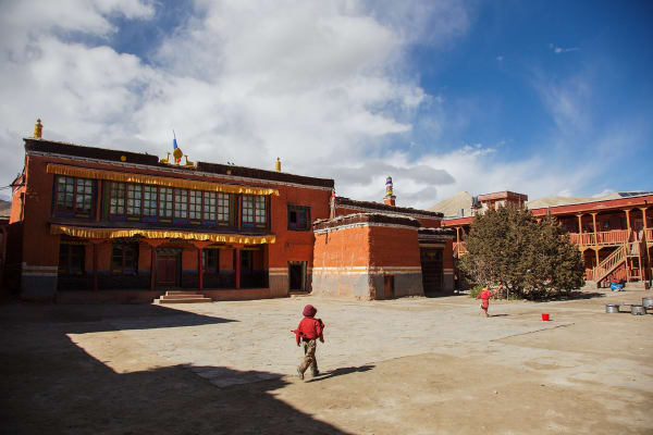
The walk up to Mu Gompa (3,700 m) takes around two hours through open, treeless country close to the Tibetan border. The monastery sits in a bare, wide basin with the border ridges immediately behind it, and the sense of remoteness is total.
Founded in the early 20th century, Mu Gompa is the largest monastery in Tsum and houses a community of monks along with old religious texts, statues and thangkas. The setting — a cluster of buildings and a chorten in an enormous empty valley — is the point as much as the building.
Nearby, Dhephyudonma Gompa is considerably older and can be added for those with energy.
Reaching around 3,700 m and sleeping lower at Nile is also useful acclimatisation for the Manaslu half of the trek.
Around 5 hours return. Overnight in Nile.
9Day 9Trek from Nile (3,361 m) to Chumling (2,386 m)
Trek from Nile (3,361 m) to Chumling (2,386 m)
A long descent back down the Tsum Valley, covering in one day what took two on the way up.
The route retraces the valley south-west, dropping around 975 m through Chokhangparo and back into the forested lower section. Descending is much quicker than climbing, and the day is long but straightforward.
Walking the valley in reverse gives a different view of it. Going up, the attention is on what lies ahead; coming down, you look out over the whole open basin with Ganesh Himal and Himalchuli across it, and the scale of the place is clearer.
There is time to stop at villages passed quickly on the way up, and the light in the afternoon on the descent is usually better for photography.
The thicker air lower down is welcome after several nights above 3,000 m.
Chumling (2,386 m) is the same village you stayed in on the way up. Around 6–7 hours. Overnight in Chumling.
10Day 10Trek from Chumling (2,386 m) to Deng (1,804 m)
Trek from Chumling (2,386 m) to Deng (1,804 m)
Leaving the Tsum Valley behind and rejoining the main Manaslu Circuit.
The trail descends steeply from Chumling through forest to Lokpa and then drops further to the Budhi Gandaki, rejoining the main circuit at the valley junction. The net loss is around 580 m, but there is plenty of climbing mixed in.
Turning north-west onto the Manaslu Circuit, the character of the trek changes. Tsum was a dead-end valley walked out and back; from here the route runs one way around the mountain to a 5,106 m pass.
The trail follows the Budhi Gandaki upstream through a steep gorge, crossing the river on suspension bridges and passing through bamboo and pine forest.
Deng (1,804 m) is a small village where the valley begins to show Tibetan influence — the first mani walls of the Manaslu section appear here.
Around 6 hours. Overnight in Deng.
11Day 11Trek from Deng (1,804 m) to Namrung (2,630 m)
Trek from Deng (1,804 m) to Namrung (2,630 m)
A climb of around 830 m up the Budhi Gandaki, with the culture shifting steadily Tibetan.
The trail continues north-west, crossing the river repeatedly and climbing through forest and small settlements. The valley narrows in sections into impressive gorges with the path cut into the rock face.
The change through the day is cultural as much as physical. The lower villages are Gurung and Hindu-influenced; as you climb past Bihi Phedi and Ghap, the architecture becomes flat-roofed and Tibetan, mani walls and chortens line the trail, and the Buddhist character becomes dominant. This upper region is known as Nupri — "the western mountains" — and its people are of Tibetan descent.
The forest here is beautiful, with rhododendron, oak and fir, and there are carved mani stones set along the path.
Namrung (2,630 m) has a checkpoint and good views ahead. Around 6–7 hours. Overnight in Namrung.
12Day 12Trek from Namrung (2,630 m) to Shyala (3,500 m)
Trek from Namrung (2,630 m) to Shyala (3,500 m)
A climb of 870 m into the high Nupri valley, with the big mountains finally appearing.
The trail climbs steadily through fir and rhododendron forest, passing Lihi, Sho and Lho. The gompa at Lho is worth the short detour above the village — it has an excellent view of Manaslu (8,163 m), which from here dominates the head of the valley.
Above Lho the forest thins and the valley opens into high alpine country. The peaks come out one after another: Manaslu itself, Manaslu North, Naike Peak and Himalchuli.
The villages through this section are unambiguously Tibetan — flat-roofed stone houses, long mani walls, chortens, and barley grown on terraces at the limit of cultivation.
Shyala (3,500 m) sits in a broad open bowl ringed by peaks, and it is one of the finest positions on the whole circuit. Around 6 hours. Overnight in Shyala.
13Day 13Trek from Shyala (3,500 m) to Sama Gaun (3,530 m)
Trek from Shyala (3,500 m) to Sama Gaun (3,530 m)
A short and easy day, deliberately gentle to aid acclimatisation.
The walk to Sama Gaun takes only a couple of hours across open alpine meadow with almost no height gain. This is by design — you will sleep two nights at 3,530 m and climb well above 4,500 m tomorrow, so an easy day now pays off later.
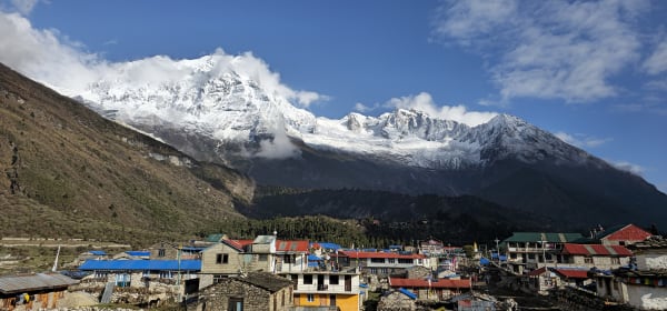
The scenery is exceptional throughout. Manaslu (8,163 m), the eighth-highest mountain in the world, fills the head of the valley, with its glaciers spilling down toward the village, and Naike Peak and Manaslu North alongside.
Sama Gaun (3,530 m) is the largest village in the upper Manaslu valley and the cultural centre of Nupri. Its people are of Tibetan origin, herding yaks and growing barley, and the village has an old gompa and long mani walls.
The afternoon is free to rest or walk gently. Around 2–3 hours. Overnight in Sama Gaun.
14Day 14Acclimatization Day – Day Trip from Sama Gaun (3,530 m) to Manaslu Base Camp (4,800+ m)
Acclimatization Day – Day Trip from Sama Gaun (3,530 m) to Manaslu Base Camp (4,800+ m)
The key acclimatisation day of the trek, and a hard one — a climb of well over 1,200 m and back.
The hike to Manaslu Base Camp (4,800+ m) is steep and sustained, climbing from the village up through moraine and rock beside the glacier. It takes most of the day and is genuinely demanding, but it is exactly the preparation the Larkya La requires: climb high, sleep low.
The base camp sits beneath the immense south face of Manaslu (8,163 m), with the glacier and icefall directly ahead and the surrounding peaks all around. In climbing season there may be expedition tents on the site.
An easier alternative is the walk to Birendra Tal, a turquoise glacial lake below the village, or up to Pungyen Gompa — both gain useful height without the full commitment.
Whichever you choose, return to sleep at Sama Gaun. Around 7–8 hours for base camp. Overnight in Sama Gaun.
15Day 15Trek from Sama Gaun (3,530 m) to Samdo (3,865 m)
Trek from Sama Gaun (3,530 m) to Samdo (3,865 m)
A short, easy day gaining around 335 m — again deliberately gentle before the pass.
The trail follows the Budhi Gandaki north through open, increasingly barren country. The treeline is well below you now, and the landscape is high-altitude scrub, moraine and rock, grazed by yaks in summer.
You pass the turning to Birendra Tal and the trail junction that leads north over the border to Tibet — this valley was a significant trading route, and Samdo's people still have close ties across the frontier.
Samdo (3,865 m) is the last permanent village before the pass, a settlement of flat-roofed stone houses founded by Tibetan refugees who crossed the border in the 1960s. Yak herding is the mainstay here.
The short day leaves the afternoon free — an optional walk toward the Tibet border viewpoint above the village is good acclimatisation.
Around 3–4 hours. Overnight in Samdo.
16Day 16Trek from Samdo (3,865 m) to Dharmasala (4,460 m)
Trek from Samdo (3,865 m) to Dharmasala (4,460 m)
A short but demanding day to the last shelter before the Larkya La.
The trail climbs steadily north-west from Samdo, crossing the Budhi Gandaki on a wooden bridge and then ascending across bare, dry, stony hillsides. The gain is around 600 m, and although the distance is modest the altitude makes it hard work.
There is no vegetation to speak of beyond hardy grass and lichen, and the landscape is entirely rock, scree and sky. Blue sheep are frequently seen on the slopes, and the surrounding peaks — Larkya Peak, Cheo Himal and the Himlung group — dominate the view.
Dharmasala (4,460 m), also called Larkya Phedi, is a bare and basic camp: a couple of stone shelters in an exposed hollow beneath the pass, often crowded, always cold, and with limited facilities.
Eat early, prepare your kit for a pre-dawn start, and sleep as much as the altitude allows. Around 4 hours. Overnight at Dharmasala.
17Day 17Trek from Dharmasala (4,460 m) to Bimthang (3,720 m) via Larkya La Pass (5,106 m)
Trek from Dharmasala (4,460 m) to Bimthang (3,720 m) via Larkya La Pass (5,106 m)
The big day of the circuit: over the Larkya La (5,106 m) and down to Bimthang.
You leave around 4 a.m. by head-torch. The climb gains around 650 m over moraine, scree and often snow, and it is long rather than steep — a series of false summits across a glacial basin, walked slowly at altitude. The early start is for the weather, which deteriorates on this pass through the morning.
The Larkya La is marked with cairns and prayer flags, and the view is one of the finest in Nepal: Himlung Himal (7,126 m), Cheo Himal, Kang Guru and Annapurna II laid out across the horizon.
The descent is the sting: more than 1,300 m of steep, loose, knee-punishing drop off the western side, often on snow near the top. Poles help enormously.
Bimthang (3,720 m) is a beautiful meadow with lodges and mountain views. A long 8–9 hours. Overnight in Bimthang.
18Day 18Trek from Bimthang (3,720 m) to Dharapani (1,860 m)
Trek from Bimthang (3,720 m) to Dharapani (1,860 m)
The final walking day, a long descent of nearly 1,900 m into the Marsyangdi valley.
The trail drops from Bimthang, crossing the moraine and glacial streams below the meadow before entering forest — first rhododendron and juniper, then dense pine, oak and eventually bamboo as you lose height.
The change over the day is dramatic. You start in bare high alpine country the morning after crossing a 5,106 m pass, and finish in warm, green, subtropical valley among terraced fields and banana palms. The oxygen and warmth both arrive quickly, and the descent, while long, feels easy.
The route passes through Karche and Goa, and the villages become Gurung and Hindu-influenced again after two weeks in Tibetan Buddhist country.
Dharapani (1,860 m) sits on the Annapurna Circuit, and joining that well-trodden trail after the emptiness of Manaslu is a striking contrast.
Around 7–8 hours. Overnight in Dharapani.
19Day 19Drive from Dharapani (1,860 m) to Kathmandu (1,400 m)
Drive from Dharapani (1,860 m) to Kathmandu (1,400 m)
A long road day out of the mountains and back to the capital.
The first stage is by 4WD jeep down the Marsyangdi valley to Besisahar — a rough, narrow, unsealed track cut into the valley wall, crossing bridges and passing under waterfalls. It is spectacular and slow, and takes several hours.
At Besisahar you join sealed road, and from there the route runs south to Dumre and then east on the Prithvi Highway, following the Trishuli back toward Kathmandu through terraced middle-hill country.
The whole journey takes most of the day, with a lunch stop along the way.
You arrive in Kathmandu (1,400 m) in the evening and transfer to your hotel. After nearly three weeks on the trail, the shower is memorable, and the evening is the natural time for a celebration with the guide and crew. Overnight in Kathmandu.
20Day 20Departure from Kathmandu (1,400 m)
Departure from Kathmandu (1,400 m)
The last day of the Tsum Valley and Manaslu Circuit Trek.
Depending on your flight time there may be free hours in the morning. Thamel is the obvious place for last-minute shopping, and Boudhanath — the centre of Kathmandu's Tibetan Buddhist community — connects directly to the gompas of Tsum and Nupri you have just walked through.
Our representative collects you from your hotel and transfers you to Tribhuvan International Airport around three hours before departure.
You leave having completed one of the great long routes of Nepal: the sacred hidden valley of Tsum up to Mu Gompa on the Tibetan border, the full circuit of Manaslu (8,163 m) with its base camp, and the crossing of the Larkya La (5,106 m) — through two restricted regions where Tibetan culture remains largely intact.
Inclusions & Exclusions
Our inclusions cover essential trekking services, accommodation, meals, permits, guide, and public transportation, while personal expenses and optional services are excluded.
What's Included
Airport pickup and drop-off services in Kathmandu.
Public transportation between Kathmandu, Maccha Khola, Dharapani, and Kathmandu as per the itinerary.
Public transportation required for all other road transfers mentioned in the itinerary.
Accommodation in Kathmandu with breakfast.
Accommodation in local teahouses during the trek.
All required trekking permits and official fees.
Professional English-speaking, licensed trekking guide.
Three meals a day (breakfast, lunch, and dinner) during the trek.
Group trekking map for route guidance.
First aid kit carried by the guide.
All government taxes, permit fees, and service charges.
What's Excluded
International flight tickets to and from Nepal.
Nepal entry visa fees.
Travel insurance, including emergency helicopter evacuation coverage.
Personal trekking equipment and clothing.
Porter services (available at an additional cost).
Lunch and dinner in Kathmandu.
Snacks, bottled water, hot showers, Wi-Fi, charging fees, and alcoholic or soft drinks.
Personal expenses such as laundry, phone calls, and souvenirs.
Tips for guides, drivers, and support staff.
Any additional accommodation, transportation, meals, or expenses caused by unforeseen circumstances, delays, road conditions, weather, or other unforeseen events beyond the itinerary.
Route Map
Follow the complete Tsum Valley and Manaslu Circuit route from Kathmandu through Tsum Valley, Manaslu Base Camp, Larkya La Pass, and Dharapani.
Loading map...
Altitude Profile
Pricing
The trek price covers the services and facilities listed in the inclusions. Optional add-ons and personal expenses are charged separately.
Add-ons
Enhance your trekking experience with optional services such as porter support, private transportation, extra accommodation, or other personalized arrangements.
Transportation
Transportation for this itinerary is based entirely on public and local transportation rather than private vehicles. This provides a more authentic experience of traveling through rural Nepal and helps keep the overall trekking cost affordable.
The journey begins with public transportation from Kathmandu to Maccha Khola, followed by the trek through Tsum Valley and the Manaslu region. After completing the circuit and reaching Dharapani, you will use local transportation to return to Kathmandu.
Road conditions in the Himalayan region can be rough and unpredictable, particularly during the monsoon and winter seasons. Travel times may therefore vary depending on road conditions, traffic, weather, and local transportation schedules.
Food and Accommodation
Food and accommodation are important parts of the Tsum Valley and Manaslu Circuit Trek. Throughout the trek, you will stay in local teahouses and mountain lodges that provide basic but comfortable accommodation. Rooms generally have twin beds, mattresses, pillows, and blankets, although facilities become more basic at higher elevations.
Meals are usually served in a communal dining area, often heated by a central stove. You can enjoy a variety of local and trekking-friendly meals such as dal bhat, rice, noodles, pasta, potatoes, vegetables, soups, Tibetan bread, eggs, and momos. Dal bhat is particularly popular because it provides a filling combination of rice, lentils, vegetables, and curry.
As you reach higher and more remote areas such as Nile, Mu Gompa, Sama Gaun, Samdo, and Dharmasala, food choices become more limited because supplies must be transported from lower elevations. We recommend eating sufficient carbohydrates, staying hydrated, and avoiding excessive alcohol during the high-altitude sections.
What the lodges are really like, from rooms and meals to showers and charging, is covered in our guide to teahouse trekking in Nepal.
Permits Required
The Tsum Valley and Manaslu Circuit Trek passes through restricted and conservation areas, so several permits are required. These permits help regulate trekking activities, protect the environment, and support local communities.
The main permits required for this itinerary include the Manaslu Restricted Area Permit (RAP), Tsum Valley Restricted Area Permit, Manaslu Conservation Area Permit (MCAP), and the Annapurna Conservation Area Permit (ACAP) for the section beyond Dharapani where applicable.
Trekkers must follow the designated route and permit requirements throughout the restricted areas. Your trekking agency and guide will arrange the necessary permits before and during the trek, so you do not need to manage the application process yourself.
The fees and conditions for every restricted area are set out in our guide to restricted area permits in Nepal.
Guides and Porters
A professional, licensed English-speaking trekking guide will accompany you throughout the trek. The guide will assist with navigation, accommodation arrangements, permits, communication with local teahouses, and general support during the journey.
Because the itinerary reaches high elevations and includes the challenging Larkya La Pass (5,106 m), having an experienced guide is particularly valuable. Your guide can also monitor your condition, help identify early signs of altitude-related problems, and coordinate assistance if necessary.
Porter service is optional and is not included in the standard package. If you prefer to trek with a lighter backpack, porters can be arranged at an additional cost. A porter can carry your main luggage while you carry only your daily essentials such as water, snacks, camera, and warm layers.
Altitude and Acclimatization
The Tsum Valley and Manaslu Circuit Trek involves significant altitude changes, with the highest point being Larkya La Pass at approximately 5,106 m (16,752 ft). The itinerary is designed with gradual altitude gain and an acclimatization day in Sama Gaun (3,530 m) to allow your body time to adjust.
The acclimatization day includes an optional hike toward Manaslu Base Camp (4,800+ m), providing an opportunity to gain altitude during the day and return to Sama Gaun for overnight rest.
As you move above 3,000 m, it is important to maintain a slow and steady pace, drink plenty of water, eat regularly, and avoid unnecessary physical exertion. Your guide will monitor the group throughout the trek and adjust the pace when necessary.
If symptoms of altitude sickness become serious, continuing higher may not be safe. In such situations, descending to a lower altitude is generally the most important response, with further medical assistance arranged when required.
Prevention, symptoms and treatment are covered in depth in our guide to altitude sickness in Nepal.
Frequently Asked Questions
Get quick answers to common questions about the Tsum Valley and Manaslu Circuit Trek, including difficulty, best seasons, connectivity, facilities, and customization.
1Is the Tsum Valley and Manaslu Circuit Trek suitable for beginners?
This trek is more suitable for trekkers with a good level of fitness and some previous trekking experience. The long walking days, remote terrain, high altitude, and Larkya La Pass make it more challenging than many shorter Nepal treks.
2What is the best season for this trek?
The best seasons are spring (March to May) and autumn (September to November). These months generally offer stable weather, clear mountain views, and favorable trekking conditions.
3How difficult is the Tsum Valley and Manaslu Circuit Trek?
The trek is considered challenging because of its long duration, remote trails, significant altitude gain, and the crossing of Larkya La Pass. Good physical preparation and proper acclimatization are important.
4How many hours do we walk each day?
Most trekking days involve approximately 5 to 8 hours of walking, depending on the destination, trail conditions, elevation gain, and the pace of the group. Some days can be longer because of difficult terrain.
5Is there mobile phone coverage during the trek?
Mobile coverage is available in some villages but can be limited or unavailable in remote sections of Tsum Valley and the Manaslu region. Coverage generally becomes less reliable as you travel deeper into the mountains.
6Is Wi-Fi available during the trek?
Wi-Fi may be available at some teahouses in larger villages, usually for an additional charge. However, connectivity can be slow or unavailable in remote areas, so trekkers should be prepared for periods without internet access.
7Can I charge my phone and camera batteries?
Charging facilities are available at many teahouses, but they become less reliable at higher elevations. Charging usually costs an additional fee, so carrying a power bank or portable charger is recommended.
8Do I need to carry Nepalese rupees during the trek?
Yes. It is recommended to carry sufficient Nepalese cash before entering the remote trekking areas. ATMs are limited or unavailable along much of the route, and many teahouses accept cash only.
9Can I take a shower during the trek?
Hot showers are available at some teahouses for an additional fee, but facilities become more basic at higher elevations. At remote locations such as Dharmasala, shower facilities may be unavailable.
10Can I customize the itinerary?
Yes, the itinerary can generally be customized according to your available time, fitness level, preferred walking pace, and interests. Additional rest days, alternative acclimatization hikes, or extra days in the mountains can be arranged when practical.
Gallery
Explore the Tsum Valley and Manaslu Circuit through realistic photographs of remote villages, Buddhist monasteries, high Himalayan landscapes, trekking trails, Manaslu Base Camp, and the dramatic Larkya La Pass.
Trekking Guides & Articles
Tsum Valley Trek: The Hidden Valley Where Hunting Is Forbidden — A restricted valley running toward Tibet off the Manaslu Circuit, where killing animals has been prohibited by Buddhist vow for generations.
Manaslu Circuit Trek: The Complete Guide — A full Himalayan circuit around the world's eighth-highest mountain, over the 5,106 m Larke La.
Crossing the Larke La: The Manaslu Circuit's Big Day — Eight to ten hours from a single basic lodge at 4,460 m over a 5,106 m pass and down 1,500 m to Bimthang.
Budhi Gandaki Flood, 11 October 2026: What Happened and What It Means for Manaslu Treks — A flash flood came down the Budhi Gandaki in northern Gorkha before dawn on Sunday 11 October 2026.
Manaslu Circuit vs Annapurna Circuit: Which Is the Better Trek? — Two fifteen-day Himalayan circuits, both over a 5,000 m pass, thirty kilometres apart.
Monasteries Where You Can Meditate on a Nepal Trek — Nepal's trekking routes pass working monasteries where visitors can sit in on prayers — Tengboche, Kyanjin, Braga, the gompas of Tsum and Mustang.
Fix Departure
This trek runs every week on the selected day(s). Choose custom dates for one-off departures.
Showing fixed departures in Oct 2026
Guest Reviews
We loved every moment
“We booked Tsum Valley and Manaslu Circuit Trek on a friend's recommendation and it was the best advice we got all year. Every sunset and mountain view along the way felt like a reward for the day's wa...
Elise Ramirez
Get in Touch
Tell us the dates you have in mind and roughly what you want out of the trek — one of our guides will reply, usually within 24 hours.
Email Us
info@greencompasstreks.com
Call Us
+977 9864379436
Office
Lakeside, Pokhara, Nepal
Office Hours
Sunday – Friday, 9:00 AM – 9:00 PM
Similar Treks
You might also like these treks


Porter
$693 $630/porter
Private Jeep from Kathmandu to Machha Khola
$275 $250/jeep
Private Jeep from Dharapani to Kathmandu
$330 $300/jeep
No payment required yet