

Ruby Valley Circuit Trek
The Ruby Valley Circuit Trek crosses the little-known country between the Ganesh Himal and the Langtang range, linking t
Porter
$347 $315/porter
No payment required yet
Trip Overview
The Ruby Valley Circuit Trek crosses the little-known country between the Ganesh Himal and the Langtang range, linking the Dhading hills to Syabrubesi over the Pangsang Pass (3,850 m). The valley takes its name from the ruby and crystal deposits historically mined in these hills, and the trail passes through Tamang and Gurung villages — Borang, Chalish, Tipling — that see almost no trekking traffic at all.
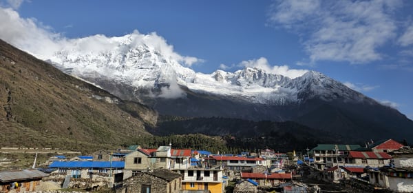
Highlights include natural hot springs at Chalish, the mixed Buddhist and Christian community at Tipling with its gompas and church side by side, and the long open ridge of Pangsang Pass with Ganesh Himal, Manaslu, and Langtang Lirung all in view. The descent through Somdang and Gatlang joins the Tamang Heritage trail before finishing at Syabrubesi. It is a genuine off-the-beaten-path route within a day's drive of Kathmandu.
Trip Highlights
Cross Pangsang Pass (3,850 m): Walk a long open ridge with Ganesh Himal, Manaslu, and Langtang Lirung visible at once.
Villages With Almost No Visitors: Pass through Borang, Chalish, and Tipling, settlements that see a handful of trekking groups a year.
Hot Springs at Chalish: Spend a rest day at natural hot springs in the middle of the Ankhu Khola valley.
The Ruby and Crystal Hills: Trek country historically mined for ruby, crystal, and zinc, which gives the valley its name.
Finish on the Tamang Heritage Trail: Descend through Somdang and the traditional Tamang village of Gatlang to Syabrubesi.
Itinerary
An 11-day circuit through the remote Ruby Valley villages of Dhading, crossing Pangsang Pass (3,850 m) to Somdang and finishing on the Tamang Heritage trail at Syabrubesi.
1Day 1Arrival in Kathmandu (1,400 m)
Arrival in Kathmandu (1,400 m)
You arrive at Tribhuvan International Airport in Kathmandu (1,400 m) and are met by our representative for the transfer to your hotel.
Your guide runs the pre-trek briefing. The Ruby Valley Circuit runs between the Ganesh Himal and Langtang ranges, crossing from Dhading district into Rasuwa over the Pangsang Pass (3,850 m). It takes its name from the ruby and other gemstone deposits historically mined in these hills.
It is one of the quietest routes within easy reach of Kathmandu. There is no domestic flight involved, the maximum altitude stays below 3,900 m, and the accommodation is a mixture of simple lodges and homestays in Tamang villages — which is much of the appeal, since the cultural contact here is closer than on the busier trails.
Your guide checks your equipment and confirms permits. The rest of the day is free to rest after your flight or explore Thamel. Overnight in Kathmandu.
2Day 2Drive from Kathmandu (1,400 m) to Dhading Bensi (634 m) and Jeep to Dondure Khola (1,500 m)
Drive from Kathmandu (1,400 m) to Dhading Bensi (634 m) and Jeep to Dondure Khola (1,500 m)
A full travel day, in two stages, ending at the trailhead.
The morning drive leaves Kathmandu on the Prithvi Highway and descends west out of the valley before turning off at Malekhu toward Dhading Bensi (634 m), the district headquarters. This first leg is on sealed road and takes around three to four hours through terraced hill country and roadside bazaars.
At Dhading Bensi you transfer to a 4WD jeep for the second stage, and the character of the journey changes completely. The road north is rough, unsealed and slow, climbing on a narrow track through remote farming country with substantial drops below.
This is a genuinely bumpy few hours, but it takes you deep into country that sees very few outside visitors.
Dondure Khola (1,500 m) is the roadhead where the walking begins. Overnight at Dondure Khola.
3Day 3Trek from Dondure Khola (1,500 m) to Borang Village (1,500 m)
Trek from Dondure Khola (1,500 m) to Borang Village (1,500 m)
The first walking day, level in net terms but undulating along the valley side.
Both ends of the day sit at the same altitude, but the trail climbs and drops repeatedly across side streams and spurs, so there is more work involved than the figures suggest. It is a gentle introduction nonetheless.
The route runs through mixed forest and terraced farmland, past scattered houses and small settlements. This is working country — millet, maize and rice on the terraces, water mills on the streams, and paths used daily by local people and livestock.
You are now entering the Tamang heartland of this circuit. The Tamang are of Tibetan origin, and the villages from here on show it: Buddhist chortens and mani walls, prayer flags, and stone houses with carved wooden windows.
Borang (1,500 m) is a traditional village where you stay in a homestay. Around 5 hours. Overnight in Borang.
4Day 4Trek from Borang Village (1,500 m) to Chalish Village (1,600 m)
Trek from Borang Village (1,500 m) to Chalish Village (1,600 m)
Another gentle day along the hillsides, with only 100 m of net gain.
The trail contours through forest and cultivated slopes, crossing streams and passing through small settlements. As with yesterday, the profile undulates rather than climbing steadily, and the pace can be relaxed.
The walking gives a close view of hill agriculture — terraces worked entirely by hand, livestock moved between fields, grain drying on rooftops, and irrigation channels running along the contours. In autumn the harvest is in full swing and the villages are busy.
As you approach Chalish the country opens and the views widen across the valleys toward the Ganesh Himal foothills.
Chalish (1,600 m), sometimes written Chalise, is a substantial Tamang village with a gompa and traditional stone architecture. You stay in a village homestay, which in practice means eating with the family and a much more direct experience of daily life than a lodge provides.
Around 4–5 hours. Overnight in Chalish.
5Day 5Rest Day and Hot Springs Exploration in Chalish Village (1,600 m)
Rest Day and Hot Springs Exploration in Chalish Village (1,600 m)
A rest day in the village, with the local hot springs as the main attraction.
The natural hot springs are a short walk from Chalish, in the river valley below. The water is warm and mineral-rich, and after three days of walking they are a genuine pleasure — as well as being a place where villagers themselves come, so it is a sociable spot rather than a tourist facility.
The rest of the day is free for the village itself. Chalish is Tamang, strongly Buddhist, and there are gompas, chortens and mani walls in and around the settlement. Traditional crafts including weaving are still practised, and the homestay arrangement makes it easy to see ordinary domestic life — butter tea, millet dhido, animals brought in at dusk.
The day also serves a practical purpose: it breaks the trek before the climbing starts in earnest, with the Pangsang Pass two days ahead.
Overnight in Chalish.
6Day 6Trek from Chalish Village (1,600 m) to Tipling (2,100 m)
Trek from Chalish Village (1,600 m) to Tipling (2,100 m)
A climbing day of around 500 m as the trek starts gaining height in earnest.
The trail leaves Chalish and climbs steadily through terraced fields before entering forest. The gradient is more sustained than the previous days, and this is the point at which the circuit turns from valley walking into a mountain route.
As you gain height the terraces thin out and the forest — oak, pine and rhododendron — takes over, with occasional clearings offering views back down the valley and ahead toward the higher ridges.
Tipling (2,100 m) is one of the more unusual villages on the circuit. It is Tamang, but unlike its neighbours it has a mixed religious character: alongside the Buddhist gompa there are two Christian churches, the result of missionary activity in the area, and the village accommodates all of them without apparent friction.
It is a large settlement with good views of the Ganesh Himal on a clear day. Around 5 hours. Overnight in Tipling.
7Day 7Trek from Tipling (2,100 m) to Pangsang Pass (3,850 m) and Descend to Somdang (3,320 m)
Trek from Tipling (2,100 m) to Pangsang Pass (3,850 m) and Descend to Somdang (3,320 m)
The big day of the circuit: a climb of 1,750 m to the Pangsang Pass (3,850 m), then a descent to Somdang.
This is a long and demanding stage and an early start is essential. The trail climbs steadily out of Tipling through forest, which thins as you gain height, and by around 3,000 m you are into juniper scrub and open grass with the treeline behind you.
The final approach to the pass is on open ground and can be windy and cold. The climb is sustained rather than technical, but 1,750 m in a day is serious work.
Pangsang Pass is a broad saddle on the divide between the Ganesh and Langtang ranges, and the panorama is the reward for the whole trek — Ganesh Himal close at hand, Langtang Lirung to the east, and on a clear day Manaslu to the west.
The descent to Somdang (3,320 m), past the old zinc and lead mine workings, takes a further couple of hours. A long 8–9 hours. Overnight in Somdang.
8Day 8Trek from Somdang (3,320 m) to Gatlang (2,238 m)
Trek from Somdang (3,320 m) to Gatlang (2,238 m)
A descent of around 1,080 m into Rasuwa district and one of the finest villages of the region.
The trail drops from Somdang, following the valley down and re-entering forest as it loses height. The walking is steady rather than steep, and after yesterday's effort it is a welcome change of pace. The vegetation thickens through the day and the temperature rises noticeably.
This section crosses from Dhading into Rasuwa district, joining the country covered by the Tamang Heritage Trail.
Gatlang (2,238 m) is the highlight of the descent — a large and strikingly well-preserved Tamang village of stone houses with carved wooden windows, set on a terraced hillside. There is a gompa, a sacred lake (Parvati Kunda) above the village, and traditional water mills still in use.
The village is well set up for homestays, and evenings often involve traditional Tamang music and dance. Around 5–6 hours. Overnight in Gatlang.
9Day 9Trek from Gatlang (2,238 m) to Syabrubesi (1,467 m)
Trek from Gatlang (2,238 m) to Syabrubesi (1,467 m)
The final walking day, descending around 770 m to the roadhead on the Bhote Koshi.
The trail leaves Gatlang and descends through forest and terraced farmland, passing through smaller Tamang settlements and crossing streams on wooden and suspension bridges. The route drops steadily toward the valley floor, and the sound of the river grows as you get lower.
There are open views back toward the ridges you crossed at Pangsang, which by this stage look impressively distant, and forward down the Bhote Koshi valley toward Langtang.
The lower slopes are warm and green, with millet and maize on the terraces and a noticeably heavier feel to the air after several days above 2,000 m.
Syabrubesi (1,467 m) sits at the confluence of the Bhote Koshi and Langtang Khola, and is the main trailhead for the whole Langtang region. It has lodges, shops and hot showers.
Around 4–5 hours. Overnight in Syabrubesi.
10Day 10Drive from Syabrubesi (1,467 m) to Kathmandu (1,400 m)
Drive from Syabrubesi (1,467 m) to Kathmandu (1,400 m)
The drive back to the capital, around 120 km but a full day on the road.
The road climbs steeply out of the Bhote Koshi valley to Dhunche, the district headquarters and the checkpoint for Langtang National Park, then continues over the ridge system before the long descent toward the Trishuli valley.
This is a spectacular but slow road, cut into steep hillsides with the valley dropping away below and a rough surface in sections. In clear weather there are good views back toward Langtang and the Ganesh Himal from the high points — including, if you know where to look, the ridge country around Pangsang.
Lower down the road passes through Trishuli Bazar before joining the highway and climbing over the Kathmandu valley rim.
You arrive in the late afternoon and transfer to your hotel. The evening is free for a hot shower, souvenir shopping or a farewell dinner. Overnight in Kathmandu.
11Day 11Final Departure from Kathmandu (1,400 m)
Final Departure from Kathmandu (1,400 m)
The last day of the Ruby Valley Circuit Trek.
Depending on your flight schedule there may be free hours in the morning. Thamel is the obvious place for last-minute shopping, and if you have longer, Boudhanath or Swayambhunath connect directly to the Buddhist culture of the Tamang villages you have just stayed in.
Our representative collects you from your hotel and transfers you to Tribhuvan International Airport approximately three hours before your international departure.
You leave having completed a circuit that crossed from Dhading into Rasuwa over the Pangsang Pass (3,850 m), between the Ganesh Himal and Langtang ranges, staying in homestays in Tamang villages — Borang, Chalish, Tipling and Gatlang — on a route that remains largely unknown despite starting only a few hours from Kathmandu.
Inclusions & Exclusions
Private transport and jeep transfers as per the itinerary, Kathmandu accommodation, homestay and community lodge stays, all trekking meals, national park permits, a licensed guide, trekking map, first aid, and government taxes are included, while international flights, visa, insurance, personal gear, porter service, city meals, personal expenses, and tips are excluded.
What's Included
Airport pickup and drop-off services in Kathmandu.
Private transportation from Kathmandu to Dhading Bensi, jeep to Dondure Khola, and transport from Syabrubesi back to Kathmandu as per the itinerary.
Accommodation in Kathmandu with breakfast.
Accommodation in local teahouses during the trek.
Langtang National Park Entry Permit and required trekking permits.
Professional English-speaking licensed trekking guide.
Three meals a day (breakfast, lunch, and dinner) during the trek.
Group trekking map for route guidance.
First aid kit carried by the guide.
Homestay and community lodge accommodation in the Ruby Valley villages as per the itinerary.
All government taxes, permit fees, and service charges.
What's Excluded
International flight tickets to and from Nepal.
Nepal entry visa fees.
Travel insurance, including emergency helicopter evacuation coverage.
Personal trekking equipment and clothing.
Porter services (available at an additional cost).
Lunch and dinner in Kathmandu.
Snacks, bottled water, hot showers, Wi-Fi, charging fees, and alcoholic or soft drinks.
Personal expenses such as laundry, phone calls, and souvenirs.
Tips for guides, drivers, and support staff.
Any additional accommodation, transportation, or expenses caused by unforeseen circumstances beyond the itinerary.
Route Map
Explore the terrain map showing the trek route.
Loading map...
Altitude Profile
Pricing
Transparent per-person pricing based on group size, covering the services listed in the itinerary with no hidden charges.
Add-ons
Customize your trek with optional services such as porter support and other personalized arrangements at an additional cost.
Best Time to Trek
March to May and October to November are the best periods. Spring brings rhododendron through the forest below Pangsang and mild village temperatures. Autumn gives the clearest conditions on the pass ridge, where the whole point is the three-range panorama, and the most reliable weather for the higher sections.
Because most of the route sits between 1,500 m and 2,200 m, the valley villages remain walkable in December and February, though Pangsang Pass and Somdang can hold snow and become difficult. The monsoon between June and August brings landslide risk on the approach road, leeches in the forest, and cloud over the pass, so it is best avoided.
For a month-by-month look at weather and trail conditions, see our guide to the best time to trek in Nepal.
Trek Difficulty & Fitness
This is a moderate trek with one demanding day. The village-to-village walking through Borang, Chalish, and Tipling involves steady climbing and descending on rough farm trails, rarely exceeding six hours. The hard day is the crossing from Tipling over Pangsang Pass to Somdang, which gains around 1,750 m and takes eight to nine hours.
You should be comfortable walking five to seven hours a day on uneven, sometimes indistinct trails. Because this is a developing route, the paths are less maintained than on the main circuits and navigation genuinely depends on your guide. Six to eight weeks of hill walking with a loaded daypack is good preparation, and trekking poles help considerably on the loose descents.
To build that fitness step by step, follow our 12-week training plan for a Nepal trek.
Travel Insurance
Travel insurance covering trekking to at least 4,500 m is required, comfortably bracketing Pangsang Pass at 3,850 m. Standard policies capped at 3,000 m would leave the pass and the Somdang section uninsured, so read the altitude clause explicitly rather than assuming your existing cover extends far enough.
The policy must include emergency helicopter evacuation and medical treatment. This is a remote route with very limited infrastructure — no lodges of any size, no medical facilities, and a road head that is often a full day's walk away — so evacuation from the middle of the circuit means a helicopter, which operators dispatch only against a guarantee of payment. Please send us your policy number and the insurer's 24-hour emergency contact before departure.
Our guide to travel insurance for trekking in Nepal explains the altitude limits, evacuation terms and common exclusions to check before you buy.
Packing List
Village nights are mild but the pass and Somdang are cold and exposed. Bring waterproof trekking boots, three base layers, a fleece, an insulated down jacket, a waterproof and windproof shell jacket and trousers, trekking trousers, a warm hat, sun hat, gloves, and wool socks. A sleeping bag rated to -10°C is right for Somdang, and a liner is worth having for the homestays.
Also pack a 30-litre daypack, trekking poles for the long pass descent, a headlamp with spare batteries, high-SPF sunscreen and lip balm, sunglasses, a reusable bottle with purification tablets or a filter, a personal first aid kit with blister care, insect repellent and leech socks for the forest sections, a quick-dry towel, toiletries, a power bank, and a swimsuit or quick-dry shorts for the Chalish hot springs. Charging opportunities are scarce, so bring more battery capacity than you think you need.
For the complete kit list, organised by the altitude you will reach, see our Nepal trekking packing list.
Accommodation, Food & Drinking Water
You stay in a tourist-standard hotel in Kathmandu and in homestays and very simple village lodges along the trail. This is a developing trekking area with no commercial teahouse infrastructure — accommodation means a room in a family home or a basic community lodge, with foam mattresses, blankets, shared or outdoor toilets, and no hot showers outside the hot springs at Chalish. Standards are low by Annapurna or Everest measures and hospitality is high.
Three meals a day are included on the trek. You eat what the household cooks: dal bhat with locally grown vegetables, dhido made from millet or buckwheat, potatoes, eggs, chapati, and tea. Menus in the western sense do not exist, so tell us in advance about vegetarian, vegan, or allergy requirements — village shops are minimal and nothing can be substituted at short notice. Water comes from village taps and streams and must be treated with tablets, a filter, or a UV pen; bottled water is not reliably available anywhere on the circuit.
What the lodges are really like, from rooms and meals to showers and charging, is covered in our guide to teahouse trekking in Nepal.
Frequently Asked Questions
Find quick answers to common questions about the Ruby Valley Circuit Trek.
1How many hours do we walk each day?
Five to seven hours on most days. The crossing from Tipling over Pangsang Pass to Somdang is the exception at eight to nine hours with around 1,750 m of ascent, making it comfortably the hardest day on the circuit.
2Which permits are required and do you arrange them?
You need the Langtang National Park Entry Permit for the Gatlang and Syabrubesi section and trekking registration. Both are included in your package and arranged by our team from passport copies and photographs sent before departure.
3How remote is this trek?
Very. You may not see another trekking group for the entire circuit. There are no commercial lodges, no ATMs, no medical posts, and no English menus. Everything depends on your guide's relationships with village households, which is exactly what makes it worth doing.
4Why is it called the Ruby Valley?
The hills around Somdang and the Ankhu Khola have historically been mined for ruby, crystal, and zinc, and small-scale extraction still takes place. You will pass old workings on the descent from Pangsang Pass, and your guide can point them out.
5What is unusual about Tipling village?
Tipling has both active Buddhist gompas and a Christian church serving parts of the community, standing within a short walk of each other. It is an uncommon arrangement in rural Nepal and makes for an interesting stop.
6Is mobile network and Wi-Fi available?
Coverage is patchy at best in the valley villages and absent over the pass and around Somdang. Wi-Fi is not available anywhere on the circuit. Plan on being effectively offline for the full trek.
7Can I charge my devices on the trail?
Charging is limited and usually solar-powered, available in some village homes for a small fee but not dependable. Bring a large power bank and treat lodge charging as a bonus rather than something to plan around.
8Where can I withdraw cash?
There are no ATMs anywhere on the circuit. Carry all your Nepalese rupees from Kathmandu — homestays, village shops, and the hot springs are strictly cash-only.
9How long is the drive from Kathmandu to the trailhead?
Around six to seven hours to Dhading Bensi and then by jeep to Dondure Khola on rough mountain road. The final section is slow and can be affected by conditions, particularly in the weeks after the monsoon.
10Can I leave extra luggage in Kathmandu?
Yes. Your Kathmandu hotel stores anything you do not need on the trail free of charge until you return, which is worth doing given how basic the accommodation is on this route.
Gallery
Explore authentic moments, landscapes, and mountain views from the Ruby Valley Circuit Trek.
Trekking Guides & Articles
Ruby Valley Trek: The Ganesh Himal Circuit Nobody Walks — A circuit through the Ganesh Himal foothills between Langtang and Manaslu, over the Pangsang pass.
Tamang Heritage Trail: Villages, Hot Springs, and a Tibet Border View — A cultural trek through Tamang villages west of Langtang, with homestays, natural hot springs at Tatopani, and a ridge view into Tibet from Nagthali.
Ganesh Himal Trek: The Complete Guide — A wilderness crossing between the Langtang and Manaslu ranges, over the Singla Pass at 4,600 m, within a day's drive of Kathmandu.
Short Treks Near Kathmandu: Himalayan Walks in 2 to 6 Days — You do not need a flight or a fortnight to see the Himalaya from Kathmandu.
Paldor Peak Climbing: The Complete Guide — One of the first peaks the NMA opened and still one of the least climbed — a classic PD+ snow and ice ridge in the Ganesh Himal.
Fix Departure
This trek runs every week on the selected day. Choose custom dates for one-off departures.
Showing fixed departures in Oct 2026
Guest Reviews
Incredible trek, incredible team
“This was my first proper trek and the team made it feel easy and enjoyable. Our porter carried our bags without complaint and always greeted us with a smile at the day's end. The whole team looked aft...
Mason Short
Get in Touch
Tell us the dates you have in mind and roughly what you want out of the trek — one of our guides will reply, usually within 24 hours.
Email Us
info@greencompasstreks.com
Call Us
+977 9864379436
Office
Lakeside, Pokhara, Nepal
Office Hours
Sunday – Friday, 9:00 AM – 9:00 PM
Similar Treks
You might also like these treks

Porter
$347 $315/porter
No payment required yet