

Annapurna Circuit with Tilicho Lake Trek
The Annapurna Circuit with Tilicho Lake Trek compresses the classic circuit into 14 days by driving straight to Chame, t
Porter
$424 $385/porter
Flight from Pokhara to Kathmandu
$127 $115/person
No payment required yet
Trip Overview
The Annapurna Circuit with Tilicho Lake Trek compresses the classic circuit into 14 days by driving straight to Chame, then adds the region's finest side trip — the walk to Tilicho Lake (4,919 m), one of the highest lakes in the world, cradled in a bare glacial basin beneath Tilicho Peak.
From Chame the trail climbs through Pisang to Manang (3,540 m) for an acclimatization day, then branches west along the exposed Khangsar traverse to Tilicho Base Camp. After the lake, the route rejoins the main circuit at Yak Kharka for the crossing of Thorong La Pass (5,416 m) and the descent to Muktinath, Jomsom, and the Kali Gandaki valley. It is the most efficient way to combine both of the Annapurna region's great high-altitude objectives in a single trip.
Trip Highlights
Tilicho Lake (4,919 m): Hike to one of the highest lakes on earth, set in a stark glacial cirque beneath Tilicho Peak.
Cross Thorong La Pass (5,416 m): Complete the Annapurna Circuit's high crossing and descend into the arid Mustang landscape beyond.
The Khangsar Traverse: Walk the dramatic and exposed cliff trail from Khangsar to Tilicho Base Camp, one of the most memorable sections of the route.
Acclimatization Day in Manang: Use a full rest day in the circuit's largest village, with viewpoints, monasteries, and an altitude briefing before the high country.
The Sacred Site of Muktinath: Visit the temple complex holy to Hindus and Buddhists alike, with its 108 water spouts and natural eternal flame.
Itinerary
A 14-day Annapurna Circuit starting at Chame, with an acclimatization day in Manang, the Tilicho Lake hike at 4,919 m, and the Thorong La Pass crossing.
1Day 1Arrival in Kathmandu (1,400 m)
Arrival in Kathmandu (1,400 m)
You land at Tribhuvan International Airport in Kathmandu (1,400 m), where our representative meets you and transfers you to your hotel.
Your guide runs the pre-departure briefing. The Annapurna Circuit with Tilicho Lake is the classic circuit with its most demanding worthwhile addition: instead of going straight from Manang toward the pass, the route detours west to Tilicho Lake (4,919 m), one of the highest lakes in the world, before rejoining the main trail for Thorong La (5,416 m).
That combination means two separate excursions above 4,900 m, and the itinerary is built with the acclimatisation to support them. Your guide checks your equipment — this trek needs genuine cold-weather kit, as the pass morning is often well below freezing — and confirms your ACAP permit and TIMS card.
The rest of the day is yours to rest after the flight or walk around Thamel. Overnight in Kathmandu.
2Day 2Drive from Kathmandu (1,400 m) to Besisahar (830 m) and Jeep to Chame (2,670 m)
Drive from Kathmandu (1,400 m) to Besisahar (830 m) and Jeep to Chame (2,670 m)
A long travel day that covers in one go what used to take four days of walking.
The morning is spent on the Prithvi Highway heading west out of the Kathmandu valley, following the Trishuli River through its gorge before turning north at Dumre toward Besisahar (830 m), the traditional starting point of the circuit.
At Besisahar you change into a 4WD jeep for the rough road up the Marsyangdi valley. This section is spectacular and genuinely rugged — a narrow track cut into the valley wall, crossing suspension bridges and passing directly under waterfalls, with the river running fast and grey below. Progress is slow and bumpy, but the scenery more than compensates.
The valley narrows and climbs steadily through Jagat and Tal, and the vegetation shifts from subtropical to pine as you gain height. Chame (2,670 m) is the administrative headquarters of Manang district. Overnight in Chame.
3Day 3Trek from Chame (2,670 m) to Pisang (3,250 m)
Trek from Chame (2,670 m) to Pisang (3,250 m)
The first full walking day, climbing gently for around 600 m through pine forest into the upper Marsyangdi.
The trail leaves Chame and follows the river upstream through deep forest of blue pine and fir. After around two hours you reach the astonishing Paungda Danda — a curved rock slab rising more than 1,500 m in a single sweep from the riverbed, one of the most striking natural features on the entire circuit.
Beyond it the valley opens and the climate changes noticeably. You are crossing into the rain shadow of the Annapurnas, and the vegetation begins thinning toward the dry, high-desert character of Manang.
Annapurna II (7,937 m) dominates the view ahead, with Pisang Peak rising to the north. The trail passes through Lower Pisang (3,250 m), a village of flat-roofed stone houses with prayer flags and a gompa — the architecture and the Buddhist culture here are recognisably Tibetan. Around 5–6 hours. Overnight in Pisang.
4Day 4Trek from Pisang (3,250 m) to Manang (3,540 m)
Trek from Pisang (3,250 m) to Manang (3,540 m)
One of the finest days on the circuit, and an important one for acclimatisation.
There are two routes. The upper trail via Ghyaru (3,730 m) and Ngawal (3,660 m) climbs steeply out of Pisang and is significantly harder work, but it is the one to take: the extra height helps acclimatisation, and the views across the valley to the Annapurna II, III and IV wall are the best on the whole route. Ghyaru and Ngawal are old, tightly packed Tibetan-style villages with mani walls and chortens.
The trail then descends to rejoin the valley floor at Braga (3,450 m), where a 500-year-old gompa is built into the cliff above the village and holds an important collection of statues and thangkas.
A short walk further brings you to Manang (3,540 m), the largest settlement in the upper valley, with Gangapurna (7,455 m) and its glacier directly across the river. Around 6–7 hours. Overnight in Manang.
5Day 5Acclimatization and Exploration Day in Manang (3,540 m)
Acclimatization and Exploration Day in Manang (3,540 m)
A rest day at 3,540 m — but an active one. The principle is to climb high and sleep low, so the day involves a hike rather than sitting still.
Options include the climb to the Gangapurna Lake viewpoint just above the village, the steeper ascent toward Praken Gompa (3,950 m) where a resident lama gives blessings to trekkers heading for the pass, or the longer walk toward Ice Lake (4,600 m) for those feeling strong. Any of these gets you several hundred metres above sleeping height and back down again, which is exactly what the body needs.
Manang itself is worth time. It is a genuine high-altitude town of flat-roofed stone houses, with bakeries, gear shops and a small cinema. The Himalayan Rescue Association runs a free daily talk on altitude sickness — attend it, particularly with Tilicho and Thorong La both ahead.
Overnight in Manang.
6Day 6Trek from Manang (3,540 m) to Khangsar (3,734 m)
Trek from Manang (3,540 m) to Khangsar (3,734 m)
A short, easy day that turns off the main circuit and starts the Tilicho detour.
Most trekkers leaving Manang head north-west toward Yak Kharka and the pass. You instead cross the Marsyangdi and follow the Khangsar Khola west, into a side valley that sees a fraction of the traffic. The change is immediate — within an hour the crowds are gone.
The walking is gentle, gaining under 200 m across open, dry hillside with almost no vegetation beyond scrub and hardy grass. This is high desert: the Annapurna wall to the south blocks the monsoon, and the landscape is brown, grey and enormous.
Khangsar (3,734 m) is described locally as the last village of Nepal in this direction — a small, weathered settlement of stone houses and a modest gompa. The short day is deliberate, keeping the altitude gain low before the serious climbing starts. Around 3–4 hours. Overnight in Khangsar.
7Day 7Trek from Khangsar (3,734 m) to Tilicho Base Camp (4,150 m)
Trek from Khangsar (3,734 m) to Tilicho Base Camp (4,150 m)
A short day in distance but a demanding one in character, crossing the most exposed terrain on the trek.
The trail climbs from Khangsar past the ruins of the old Khangsar gompa and continues west into an increasingly barren valley. After the last teahouse the route reaches the section this detour is known for: the landslide traverse, a narrow path cut across steep, loose scree slopes that drop several hundred metres to the river.
It requires care and steady footing rather than technical skill, and it is best crossed in the morning before the wind gets up. Your guide will set the pace and spacing. Rockfall is a genuine consideration here, so this is not a section to linger on.
Beyond the traverse the valley opens into a wide, stony basin. Tilicho Base Camp (4,150 m) is a small group of lodges in an otherwise entirely empty landscape of rock and sky. Nights are cold. Around 4–5 hours. Overnight at Tilicho Base Camp.
8Day 8Hike from Tilicho Base Camp (4,150 m) to Tilicho Lake (4,919 m) and Trek to Yak Kharka (4,050 m)
Hike from Tilicho Base Camp (4,150 m) to Tilicho Lake (4,919 m) and Trek to Yak Kharka (4,050 m)
The longest and hardest day of the trek: nearly 800 m of climbing to the lake, then a full descent and traverse back to the main circuit.
You start before dawn. The trail climbs relentlessly up a series of switchbacks on open scree — there is no shelter and no water, and at this altitude the pace is necessarily slow. It takes most people three to four hours to reach the rim.
Tilicho Lake (4,919 m) is one of the highest lakes in the world, roughly 4 km long, held in a bowl of bare rock beneath the Grande Barrière. It is frozen for much of the year; when open, the water is an intense turquoise from glacial rock flour. Nothing grows here at all. It is a genuinely austere, silent place.
After time at the lake you descend to base camp, then recross the landslide section and traverse to Yak Kharka (4,050 m) on the main circuit. A very long day of 8–10 hours. Overnight at Yak Kharka.
9Day 9Trek from Yak Kharka (4,050 m) to Thorong Phedi (4,450 m)
Trek from Yak Kharka (4,050 m) to Thorong Phedi (4,450 m)
A deliberately short day, positioning you at the foot of the pass with as much rest as possible.
The trail climbs gently north from Yak Kharka (4,050 m) along the eastern side of the valley, through high pasture where yaks graze in summer. There is no forest at this height — the ground is grass, moss and rock, with the peaks of the Chulu range across the valley.
After around an hour and a half the route crosses the Marsyangdi on a wooden bridge at Ledar and traverses a stretch of loose scree on the valley wall. This section is narrow and exposed in places and requires attention, particularly if there is snow.
Thorong Phedi (4,450 m) — the name simply means "foot of the hill" — is a cluster of stone lodges in a bare hollow beneath the pass. Eat early, prepare your kit for a pre-dawn start, and sleep as much as the altitude allows. Around 3–4 hours. Overnight at Thorong Phedi.
10Day 10Day 10: Trek from Thorong Phedi (4,450 m) to Muktinath (3,800 m) via Thorong La Pass (5,416 m)
Day 10: Trek from Thorong Phedi (4,450 m) to Muktinath (3,800 m) via Thorong La Pass (5,416 m)
The big day of the circuit: over Thorong La (5,416 m), one of the highest trekking passes in the world.
You leave between 4 and 5 a.m. by head-torch. The start is the steepest part of the whole climb, a punishing set of switchbacks up to High Camp (4,880 m). Above that the gradient eases but the altitude bites — the last stretch is a long, slow series of false summits across open snow and scree, walked at a deliberately slow pace with frequent short stops. The early start is not for the view but for the wind, which rises sharply through the morning.
The pass itself is marked by a cairn and a mass of prayer flags, with mountains in every direction. It is bitterly cold and rarely a place to stay long.
The descent is relentless — over 1,600 m of knee-punishing drop into the arid Mustang landscape, arriving at the pilgrimage town of Muktinath (3,800 m), sacred to Hindus and Buddhists alike. 7–9 hours. Overnight in Muktinath.
11Day 11Trek from Muktinath (3,800 m) to Jomsom (2,700 m)
Trek from Muktinath (3,800 m) to Jomsom (2,700 m)
A descent into the Kali Gandaki, through some of the most distinctive landscape in Nepal.
Before setting off, visit the Muktinath temple complex — the 108 water spouts, the eternal flame burning on natural gas beside a spring, and the Vishnu shrine that makes this one of the most important pilgrimage sites in the Himalaya.
The trail then descends through the ancient village of Jharkot, with its ruined fort and red-walled monastery, and continues down to the Kali Gandaki — which, running between Dhaulagiri and Annapurna, carves the deepest gorge on earth.
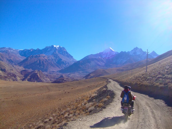
You reach Kagbeni (2,800 m), a medieval-looking village of mud-brick alleyways and a red gompa, marking the checkpoint into restricted Upper Mustang. From here the route turns south down the broad, stony riverbed to Jomsom (2,700 m). The valley wind here is famously strong from late morning, blowing hard up the gorge. Around 5–6 hours. Overnight in Jomsom.
12Day 12Drive from Jomsom (2,700 m) to Pokhara (822 m)
Drive from Jomsom (2,700 m) to Pokhara (822 m)
A long and dramatic road day, following the Kali Gandaki out of the mountains.
The jeep road runs south down the gorge between Dhaulagiri (8,167 m) and Annapurna I (8,091 m) — the two eight-thousanders that make this the deepest valley in the world. The scenery changes completely over the course of the drive: the dry, treeless, Tibetan-influenced upper valley gives way to pine forest, then to the terraced green hillsides and banana palms of the middle hills.
The road passes Marpha, a whitewashed village famous across Nepal for its apple orchards and apple brandy, and Tatopani, where hot springs run beside the river. It is rough going in sections and the driving is slow, with river crossings and landslide-prone stretches.
The final hours run on sealed road through Beni and Baglung before Pokhara (822 m). Arrive in the evening. Overnight in Pokhara.
13Day 13Drive from Pokhara (822 m) to Kathmandu (1,400 m)
Drive from Pokhara (822 m) to Kathmandu (1,400 m)
The return along the Prithvi Highway to Kathmandu, around 200 km and most of the day.
The road follows the Marsyangdi and then the Trishuli east, through the terraced middle hills of central Nepal. It is a relaxed way to end the trip, watching rural Nepal pass by — hillsides farmed in steps to impossible angles, roadside bazaars, suspension footbridges strung across the rivers, and rafting groups on the water below. We stop for lunch at a riverside restaurant along the way.
As you approach the Kathmandu valley the road climbs over the rim at Naubise and drops into the city.
You arrive in the late afternoon, transfer to your hotel, and have the evening free — time for a hot shower, last-minute shopping in Thamel for souvenirs, or a farewell meal with your guide and crew. Overnight in Kathmandu.
14Day 14Departure from Kathmandu (1,400 m)
Departure from Kathmandu (1,400 m)
The final day of the Annapurna Circuit with Tilicho Lake Trek.
Depending on your flight time, there may be a few free hours in the morning. Thamel is the obvious place for last-minute purchases, and the nearby heritage sites — Boudhanath, Swayambhunath or Patan Durbar Square — are all worth a short visit if you have half a day, and make a fitting counterpoint to the mountains after two weeks of walking.
Our representative collects you from your hotel and transfers you to Tribhuvan International Airport around three hours before departure.
You leave having crossed one of the highest trekking passes in the world at Thorong La (5,416 m) and stood beside Tilicho Lake (4,919 m) — a combination that takes in the full range of the Annapurna region, from subtropical river valley to high-altitude desert.
Inclusions & Exclusions
Jeep and tourist bus transport as per the itinerary, Kathmandu and Pokhara accommodation, teahouse lodging, all trekking meals, conservation area permits, a licensed guide, trekking map, first aid, and government taxes are included, while international flights, visa, insurance, personal gear, porter service, city meals, personal expenses, and tips are excluded.
What's Included
Airport pickup and drop-off services in Kathmandu.
Ground transportation from Kathmandu to Besisahar and shared jeep from Besisahar to Chame as per the itinerary.
Shared jeep transportation from Jomsom to Pokhara.
Tourist bus transportation from Pokhara to Kathmandu.
Accommodation in Kathmandu with breakfast.
Accommodation in Pokhara with breakfast.
Accommodation in local teahouses during the trek.
Annapurna Conservation Area Permit (ACAP) and required trekking permits.
Professional English-speaking licensed trekking guide.
Three meals a day (breakfast, lunch, and dinner) during the trek.
Group trekking map for route guidance.
First aid kit carried by the guide.
All government taxes, permit fees, and service charges.
What's Excluded
International flight tickets to and from Nepal.
Nepal entry visa fees.
Travel insurance, including emergency helicopter evacuation coverage.
Personal trekking equipment and clothing.
Porter services (available at an additional cost).
Lunch and dinner in Kathmandu and Pokhara.
Snacks, bottled water, hot showers, Wi-Fi, charging fees, and alcoholic or soft drinks.
Personal expenses such as laundry, phone calls, and souvenirs.
Tips for guides, drivers, and support staff.
Any additional accommodation, transportation, or expenses caused by unforeseen circumstances beyond the itinerary.
Route Map
Explore the terrain map showing the trek route.
Loading map...
Altitude Profile
Pricing
Transparent per-person pricing based on group size, covering the services listed in the itinerary with no hidden charges.
Add-ons
Customize your trek with optional services such as porter support and other personalized arrangements at an additional cost.
Best Time to Trek
March to May and September to November are the seasons that work. Autumn brings the most settled weather for both Tilicho and Thorong La, with clear air and firm underfoot conditions. Spring is warmer and greener in the lower Marsyangdi, and the Tilicho basin holds more snow, which makes the lake setting particularly striking.
In winter both the Khangsar traverse and Thorong La are frequently blocked by snow, and Tilicho Base Camp closes in heavy conditions, so December to February carries a real chance of not completing the route. During the monsoon the Manang valley sits partly in the rain shadow and stays drier than most of Nepal, but landslides affect the drive to Chame and cloud obscures the peaks.
For a month-by-month look at weather and trail conditions, see our guide to the best time to trek in Nepal.
Altitude & Acclimatization
Because this itinerary drives directly to Chame (2,650 m), you start higher than on the full circuit, which makes the acclimatization day at Manang (3,519 m) genuinely important rather than optional. The Tilicho Lake hike that follows is a textbook climb-high, sleep-low day — you gain nearly 800 m to the lake and descend to Yak Kharka to sleep.
That sequence prepares the body well for Thorong La, which is crossed from Thorong Phedi with a pre-dawn start. Your guide watches the group each evening for headache, disturbed sleep, appetite loss, and breathlessness at rest, and will add a night at Manang or Yak Kharka if anyone needs it. Drink three to four litres a day, keep the pace conversational, avoid alcohol from Manang upward, and speak up early — descent resolves altitude illness quickly and there is no cost to being cautious.
Prevention, symptoms and treatment are covered in depth in our guide to altitude sickness in Nepal.
Travel Insurance
Travel insurance covering trekking to at least 6,000 m is mandatory. Thorong La at 5,416 m and Tilicho Lake at 4,919 m both sit far above the limits of ordinary policies, which commonly cap at 3,000 m or 4,000 m, so verify the altitude clause explicitly before purchasing rather than assuming your existing cover applies.
Your policy must include emergency helicopter evacuation and repatriation, plus medical treatment and trip cancellation. The Khangsar traverse and the approach to Thorong La have no vehicle access, and helicopter operators require a guarantee of payment before they will fly. Please send us your policy number and the insurer's 24-hour emergency contact before you leave Kathmandu.
Our guide to travel insurance for trekking in Nepal explains the altitude limits, evacuation terms and common exclusions to check before you buy.
Trek Difficulty & Fitness
This is a challenging itinerary and slightly more demanding than the standard circuit despite being shorter, because the fast start at Chame gives less time to adapt and the Tilicho detour adds two hard days at altitude. The Khangsar traverse crosses loose, exposed scree slopes where a steady head for narrow trails is genuinely useful.
You should be able to walk six to eight hours a day for several consecutive days and cope with a very long pass day involving a 1,000 m climb and a 1,700 m descent. Prepare with two to three months of hill walking with a loaded pack, plus cardiovascular work. Trekking poles are strongly recommended for the Khangsar scree and the descent from Thorong La to Muktinath.
To build that fitness step by step, follow our 12-week training plan for a Nepal trek.
Accommodation, Food & Drinking Water
You stay in tourist-standard hotels in Kathmandu and Pokhara and in teahouses throughout the trek. Manang, Chame, Muktinath, and Jomsom all offer comfortable lodges with hot showers and good dining rooms. Khangsar, Tilicho Base Camp, and Thorong Phedi are noticeably more basic — small twin rooms or dormitories, shared toilets, and heating only where everyone eats. Tilicho Base Camp has limited beds, so we arrive early in peak season.
Three meals a day are included on the trek. Breakfast is porridge, eggs, Tibetan bread, or pancakes; lunch and dinner are ordered from the lodge menu, with dal bhat and unlimited refills the best value alongside noodles, fried rice, momos, soups, and pasta. Manang has a surprisingly wide choice including bakeries. Refill your bottle at lodges or the safe drinking water stations along the trail and treat it with tablets, a filter, or a UV pen rather than buying plastic bottles.
What the lodges are really like, from rooms and meals to showers and charging, is covered in our guide to teahouse trekking in Nepal.
Frequently Asked Questions
Find quick answers to common questions about the Annapurna Circuit with Tilicho Lake Trek.
1How does this compare with the full Annapurna Circuit?
This itinerary drives to Chame rather than walking the lower Marsyangdi, saving several days on road-affected sections while keeping every high-altitude highlight. You get Tilicho Lake and Thorong La in fourteen days instead of fifteen or more, at the cost of a faster initial ascent.
2How many hours do we walk each day?
Most days run five to seven hours. The Tilicho Lake day is eight to nine hours and the Thorong La crossing is eight to ten, both starting before dawn to take advantage of stable morning conditions and to reach the pass before the afternoon wind.
3Which permits are required and do you arrange them?
The Annapurna Conservation Area Permit and trekking registration are both included and arranged by our team. We need passport copies and passport-sized photographs before departure; no restricted-area permit applies to this route.
4Is the Khangsar to Tilicho Base Camp trail dangerous?
It crosses steep, loose scree with some exposure, and rockfall is possible, so groups cross in the morning when conditions are most stable. It is not technical and no equipment is needed, but trekking poles and a steady pace make a real difference, and your guide will hold the group if conditions are poor.
5What happens if Thorong La is closed by snow?
If the pass is unsafe, the group either waits for conditions to improve or descends the Marsyangdi valley and travels round by road. Your guide makes that decision with lodge owners and the local trekking post, and safety takes priority over completing the circuit.
6Can I charge devices and is Wi-Fi available?
Lodges offer charging for a small fee and most sell Wi-Fi access. Coverage is reliable in Chame, Manang, Muktinath, and Jomsom and absent at Tilicho Base Camp and on the pass. Bring a power bank, as cold weather drains batteries quickly at altitude.
7Where can I withdraw cash?
There are ATMs in Chame, Manang, and Jomsom, but they run out of cash and go offline without warning. Carry enough Nepalese rupees from Kathmandu or Pokhara to cover the full trek, including snacks, drinks, charging, showers, and tips.
8How cold does it get at night?
Tilicho Base Camp and Thorong Phedi typically fall to between -10°C and -20°C in the main seasons, and the pre-dawn hours on the pass are colder still with wind chill. A sleeping bag rated to -15°C plus a liner is the right specification.
9How large are the groups and who leads the trek?
Groups are capped at twelve trekkers and led by a licensed English-speaking guide with experience on both the Tilicho traverse and Thorong La. We add an assistant guide for larger groups so the party can split by walking pace.
10Can I leave extra luggage in Kathmandu?
Yes. Your Kathmandu hotel stores anything you do not need on the trail free of charge until you return, so you can leave city clothes, spare gear, and valuables behind.
Gallery
Explore authentic moments, landscapes, and mountain views from the Annapurna Circuit with Tilicho Lake Trek.
Trekking Guides & Articles
Crossing Thorong La: The Biggest Day on the Annapurna Circuit — A 4 a.m.
Annapurna Circuit Trek: The Complete Guide — One of the great walks of the world: a circuit from subtropical valleys over the 5,416 m Thorong La into Tibetan-Buddhist high desert.
Breathing Exercises for High-Altitude Trekking in Nepal — Breathing exercises will not acclimatise you, whatever the internet says.
Tilicho Lake Trek: The Highest Large Lake in the World — Tilicho Lake sits at 4,919 m in a bowl of bare rock behind the Annapurna massif — turquoise, enormous, and reached across one of the most exposed trail sections in Nepal.
Tilicho Peak Expedition: The Complete Guide — A 7,134 m royalty peak above one of the highest large lakes in the world, climbed rarely enough that a season may pass with no ascent.
Diamox for Trekking in Nepal: When to Start, Dose and Side Effects — Diamox is the most discussed tablet on any Nepal trek, and the most misunderstood.
Fix Departure
This trek runs every week on the selected day. Choose custom dates for one-off departures.
Showing fixed departures in Oct 2026
Guest Reviews
Trip of a lifetime
“We booked Annapurna Circuit with Tilicho Lake Trek on a friend's recommendation and it was the best advice we got all year. The whole team looked after us brilliantly — nothing was ever too much troub...
Pedro Barnes
Get in Touch
Tell us the dates you have in mind and roughly what you want out of the trek — one of our guides will reply, usually within 24 hours.
Email Us
info@greencompasstreks.com
Call Us
+977 9864379436
Office
Lakeside, Pokhara, Nepal
Office Hours
Sunday – Friday, 9:00 AM – 9:00 PM
Similar Treks
You might also like these treks


Porter
$424 $385/porter
Flight from Pokhara to Kathmandu
$127 $115/person
No payment required yet