

Upper Dolpo Trek
The Upper Dolpo Trek is a spectacular 26-day adventure into one of Nepal’s most remote and culturally preserved Himalaya
Porter
$886 $805/porter
No payment required yet
Trip Overview
The Upper Dolpo Trek is a spectacular 26-day adventure into one of Nepal’s most remote and culturally preserved Himalayan regions. The journey begins in Kathmandu and continues by air to Nepalgunj and Juphal before entering the remote Dolpo wilderness. The trail passes through Dunai, Ankhe, Sulighat, and the stunning Phoksundo Lake (3,612 m), followed by the dramatic landscapes of Upper Dolpo. Major highlights include crossing Kang La Pass (5,360 m), visiting the sacred Shey Gompa (4,500 m), exploring traditional villages such as Saldang and Dho Tarap, and reaching Yangze Gompa (4,960 m).
Throughout the trek, you experience remote Himalayan valleys, ancient monasteries, traditional stone villages, Buddhist and Bon cultural traditions, deep gorges, high mountain passes, and breathtaking landscapes far from Nepal’s busy trekking routes. After crossing Jeng La Pass (5,090 m) and exploring the Tarap Valley, the trail gradually descends through Tarap Khola, Khanigaun, Tarakot, and Dunai before reaching Juphal. A flight back to Kathmandu brings this extraordinary Upper Dolpo wilderness adventure to an end.
Trip Highlights
Shey Gompa and Crystal Mountain (4,500 m): Reach the most sacred site in Dolpo, a monastery at the foot of a mountain circumambulated by pilgrims each summer.
Cross Kang La (5,360 m) and Jeng La (5,090 m): Take on two high passes linking the Phoksundo, Saldang, and Tarap valleys.
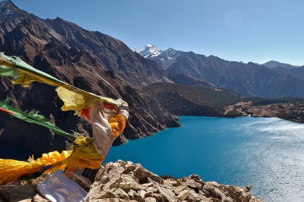
Phoksundo Lake with an Exploration Day: Spend a full day at Nepal's deepest lake, an extraordinary blue basin ringed by cliffs and a Bon monastery.
Saldang and the Tibetan Plateau Villages: Walk through walled settlements at nearly 4,000 m that farm barley on the edge of the Tibetan frontier.
The Most Committing Trek in Nepal: A 26-day traverse of restricted country with high passes, remote camps, and no road access at any point.
Itinerary
A 26-day restricted-area traverse of Upper Dolpo to Shey Gompa and Crystal Mountain, crossing Kang La (5,360 m) and Jeng La (5,090 m) via Phoksundo Lake and Saldang.
1Day 1Arrival in Kathmandu (1,400 m)
Arrival in Kathmandu (1,400 m)
You arrive at Tribhuvan International Airport in Kathmandu (1,400 m) and are met by our representative for the transfer to your hotel.
Your guide runs the pre-trek briefing. Upper Dolpo is the most remote trekking region in Nepal and among the most culturally intact Tibetan areas anywhere outside Tibet. This 26-day route crosses several passes above 5,000 m, including the Kang La (5,360 m), and visits Shey Gompa — the Crystal Monastery — beneath the sacred Crystal Mountain.
It is a restricted area with an expensive special permit, requiring a registered agency and a licensed guide, and it is a full camping expedition: there are no lodges on the high sections, so tents, food, kitchen and pack animals go with you.
This is a serious undertaking with sustained time above 4,000 m. Your guide checks equipment carefully — a four-season sleeping bag is essential.
The rest of the day is free. Overnight in Kathmandu.
2Day 2Fly from Kathmandu (1,400 m) to Nepalgunj (150 m)
Fly from Kathmandu (1,400 m) to Nepalgunj (150 m)
A short flight west to the Terai plains, staging for the mountain flight tomorrow.
The hour-long flight crosses the middle hills and descends over the flat agricultural plain of the Terai. On a clear day the Himalaya runs along the whole northern horizon — Ganesh Himal, Manaslu, Annapurna and Dhaulagiri, behind which Dolpo lies in deep rain shadow.
Nepalgunj (150 m) is a hot, humid border city close to India, and the change from Kathmandu is abrupt. It is the aviation hub for all of western Nepal and the only practical way into Dolpo.
The afternoon is free. If the heat allows, the Bageshwori Temple is worth seeing, and the bazaar has a distinctly Indian character.
Flights to Juphal go at first light and are weather-dependent, so it is an early night. Overnight in Nepalgunj.
3Day 3Fly from Nepalgunj (150 m) to Juphal (2,320 m) and Trek to Dunai (2,140 m)
Fly from Nepalgunj (150 m) to Juphal (2,320 m) and Trek to Dunai (2,140 m)
A dramatic mountain flight followed by an easy first walk.
The 45-minute flight to Juphal (2,320 m) climbs from the plains over ridge after ridge of the western hills, with the Dhaulagiri massif ahead. The airstrip is a short shelf cut into a hillside. Flights leave early because the wind rises later, and delays are routine.
The crew and pack animals meet you at Juphal, and the walking begins with a gentle descent through terraced fields and pine to the Thuli Bheri river, then upstream along the bank.
This is the easiest walking of the whole trek and a useful way to start moving at altitude.
Dunai (2,140 m) is the administrative headquarters of Dolpa district — a small town along the riverbank with a checkpoint, shops and a hospital, and the last place with any real services.
Around 2–3 hours. Overnight camping at Dunai.
4Day 4Trek from Dunai (2,140 m) to Ankhe (2,896 m)
Trek from Dunai (2,140 m) to Ankhe (2,896 m)
A climb of around 750 m as the route turns north into the Phoksundo valley.
The trail leaves Dunai and follows the Thuli Bheri briefly before turning north up the Suli Gad river toward Phoksundo. The valley narrows quickly into a gorge and the path climbs along the wall above the water, crossing side streams and suspension bridges.
The country here is still relatively green — pine, walnut and terraced barley on the lower slopes — but it thins as you climb and the gorge steepens. There are sections where the trail is cut into the rock or built out on wooden galleries.
You enter Shey Phoksundo National Park, the largest national park in Nepal, on this stage. Permits are checked at the entrance post.
Ankhe (2,896 m) is a small settlement in the gorge. Around 6 hours. Overnight camping at Ankhe.
5Day 5Trek from Ankhe (2,896 m) to Sulighat (3,180 m)
Trek from Ankhe (2,896 m) to Sulighat (3,180 m)
A rugged day in the gorge with modest net gain but constant climbing and descending.
The net figure of around 280 m badly understates the day. The trail repeatedly climbs high above the Suli Gad to get around cliffs, then drops back to the river, and the cumulative ascent is several times the net gain.
The walking is through forest of pine, birch and walnut on steep valley sides, with the river running fast below. Some sections are narrow and exposed, requiring steady footing, and landslide damage is common in this terrain.
This is good wildlife country within the national park — blue sheep on the crags, Himalayan tahr, and excellent birdlife including the Himalayan monal.
Sulighat (3,180 m) sits where the valley begins to open toward the Phoksundo basin, and the first views of the peaks around the lake appear.
Around 6 hours. Overnight camping at Sulighat.
6Day 6Trek from Sulighat (3,180 m) to Phoksundo Lake (3,612 m)
Trek from Sulighat (3,180 m) to Phoksundo Lake (3,612 m)
A climb of around 430 m to the lake — one of the great arrivals of any Nepali trek.
The trail climbs steadily through birch and blue pine, and partway up passes the Phoksundo waterfall, at around 167 m the highest in Nepal, where the lake's outflow drops sheer into the gorge. The path switchbacks steeply beside it.
Above the falls the gradient eases and the trail rounds a shoulder, and Phoksundo Lake (3,612 m) comes into view: an intense turquoise, held in a steep bowl ringed by cliffs and pine, with no fish and almost no aquatic vegetation. The colour comes from suspended glacial rock flour.
Ringmo, the village on the shore, is a traditional Tibetan-style settlement of flat-roofed stone houses with chortens and mani walls, and the Bön monastery of Thashung Gompa, around 900 years old, sits nearby.
Around 4–5 hours. Overnight camping at Phoksundo Lake.
7Day 7Explore Phoksundo Lake (3,612 m)
Explore Phoksundo Lake (3,612 m)
A rest and acclimatisation day at 3,612 m in an extraordinary setting.
This is the first proper rest of the trek and an important one — the Kang La at 5,360 m is four days away. The recommended approach is light activity rather than complete rest: the trail along the western shore climbs to a viewpoint over the whole lake and is well worth a couple of hours.
Ringmo village is the other focus of the day. Its Thashung Gompa belongs to the Bön tradition — the pre-Buddhist religion of Tibet, which survives in Dolpo more strongly than almost anywhere. Bön practitioners circumambulate anticlockwise, the reverse of Buddhist custom, which is easy to spot at the chortens.
Parts of the film Himalaya (Caravan) were shot here, and the village is much as it appears in it.
It is also a good day to wash, dry kit and eat well. Overnight camping at Phoksundo Lake.
8Day 8Trek from Phoksundo Lake (3,612 m) to Phoksundo Khola (3,507 m)
Trek from Phoksundo Lake (3,612 m) to Phoksundo Khola (3,507 m)
A short day, but one containing the most famous piece of trail in Dolpo.
The route follows the western shore of the lake, and the first section is the notorious ledge path — a narrow trail built from stone and wooden stakes, cut and pinned into a near-vertical cliff face several hundred metres above the water. It appears in Himalaya and it is every bit as airy as it looks.
It is not technically difficult and it is walked by loaded pack animals daily, but it demands full attention and a steady head. Your guide will space the group and let the animals pass.
Beyond the cliff the trail descends to the head of the lake and crosses a broad, flat alluvial plain — a striking change of scale after the ledge — before following the Phoksundo Khola upstream.
Camp is beside the river at 3,507 m. Around 4–5 hours. Overnight camping at Phoksundo Khola.
9Day 9Trek from Phoksundo Khola (3,507 m) to Phoksundo Bhanjyang (3,910 m)
Trek from Phoksundo Khola (3,507 m) to Phoksundo Bhanjyang (3,910 m)
A steady climb of around 400 m up an increasingly barren valley toward the pass.
The trail follows the Phoksundo Khola north through a narrowing valley, crossing the river on log bridges. The last of the birch and juniper is left behind during the morning, and by the afternoon the landscape is entirely bare — rock, scree and hardy alpine grass.
Progress is unhurried by design. You will cross the Kang La (5,360 m) tomorrow, so the pace today is set to arrive at camp with as much in reserve as possible.
The valley walls close in and the peaks at the head come into view. There are no settlements on this stretch and no shelter of any kind; everything is carried by the crew and the pack animals.
Phoksundo Bhanjyang (3,910 m) is an exposed camp at the foot of the pass. It is cold, and sleep is often broken at this height.
Around 4–5 hours. Overnight camping at Phoksundo Bhanjyang.
10Day 10Trek from Phoksundo Bhanjyang (3,910 m) to Shey Gompa (4,500 m) via Kang La Pass (5,360 m)
Trek from Phoksundo Bhanjyang (3,910 m) to Shey Gompa (4,500 m) via Kang La Pass (5,360 m)
The first great pass of the trek — the Kang La (5,360 m) — and the arrival at Shey Gompa.
An early start. The climb gains around 1,450 m over bare scree and rock, with no shelter and no water, and at this altitude it is slow, sustained work. It takes most people four to five hours to the top.
The Kang La is marked with cairns and prayer flags, and the view is vast: the ranges of Upper Dolpo folding away north toward Tibet, entirely brown and grey and empty, with snow peaks along the horizon.
The descent drops steeply into the Shey valley, following a river down through a gorge.
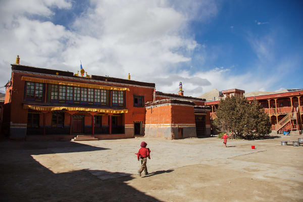
Shey Gompa (4,500 m) — the Crystal Monastery — is the spiritual centre of Dolpo, an 11th-century foundation beneath the sacred Crystal Mountain, which pilgrims circumambulate. It is the place Peter Matthiessen was travelling to in The Snow Leopard.
A long 7–8 hours. Overnight camping at Shey Gompa.
11Day 11Rest Day at Shey Gompa (4,500 m)
Rest Day at Shey Gompa (4,500 m)
A rest and acclimatisation day at 4,500 m at the spiritual heart of Dolpo.
After the Kang La this is a needed break, and there is a great deal to see without going far.
Shey Gompa, the Crystal Monastery, dates to the 11th century and belongs to the Kagyu school. Its red buildings and chorten sit beneath Crystal Mountain — Shelri — a peak of quartz-veined rock regarded as sacred and circumambulated by pilgrims, particularly during the summer festival. The full kora around the mountain takes a day and is a serious walk at this altitude; a shorter section can be done instead.
Tsakang Gompa, a meditation retreat built into a cliff face nearby, is also worth the walk.
This region is prime snow leopard habitat, and blue sheep — their main prey — are commonly seen on the slopes.
Overnight camping at Shey Gompa.
12Day 12Trek from Shey Gompa (4,500 m) to Namduna Gaun (4,400 m)
Trek from Shey Gompa (4,500 m) to Namduna Gaun (4,400 m)
A high traverse over the Saldang La (5,010 m) with little net height change.
The day looks flat on paper — a loss of 100 m — but it involves a full 500 m climb to the pass and an equivalent descent, all above 4,400 m.
The trail climbs from Shey through a barren valley of rock and scree to the Saldang La, marked with cairns and prayer flags. The views from the top run north toward the Tibetan border and back over the Crystal Mountain massif.
The descent leads into a wide, dry valley. This is classic Upper Dolpo terrain: no trees, almost no vegetation, enormous horizontal scale, and colours running from ochre to grey to deep red in the rock bands.
Namduna Gaun (4,400 m) is a small settlement with the Namgung Gompa, a red monastery built into a cliff face above the village — a striking sight in such empty country.
Around 6 hours. Overnight camping at Namduna Gaun.
13Day 13Trek from Namduna Gaun (4,400 m) to Saldang (3,903 m)
Trek from Namduna Gaun (4,400 m) to Saldang (3,903 m)
A descent of around 500 m to the largest village in Upper Dolpo.
The trail descends through arid, open country, following the valley south-east. The walking is straightforward and the day relatively short, which after several hard stages is welcome.
Saldang (3,903 m) is the biggest settlement in Upper Dolpo, strung out for over a kilometre along a terraced hillside above the river. It has several hundred residents in a series of linked hamlets, with barley and buckwheat fields irrigated by channels from the snowmelt.
The culture is entirely Tibetan — the language, the flat-roofed mud-brick architecture, the chortens and mani walls, and the Buddhist and Bön monasteries in and around the village. Saldang sits on an old trans-Himalayan trading route, and salt, wool and grain still move north and south across the border here.
It is a good place to spend an afternoon watching ordinary life. Around 4–5 hours. Overnight camping at Saldang.
14Day 14Trek from Saldang (3,903 m) to Yangze Gompa (4,960 m)
Trek from Saldang (3,903 m) to Yangze Gompa (4,960 m)
A substantial climb of around 1,050 m into the far north of Dolpo.
The trail leaves Saldang and climbs steadily north through completely barren country. This is one of the biggest single ascents of the trek, and at these altitudes it is slow going, but you are well acclimatised by this stage.
The landscape is severe and beautiful — bare rock and scree in bands of red, ochre and grey, deeply eroded, with no vegetation beyond lichen and the toughest cushion plants. Blue sheep are frequently seen and Himalayan griffons ride the thermals overhead.
You are close to the Tibetan border here, and the sense of remoteness is complete. Settlements are tiny and far apart.
Yangze Gompa (4,960 m) is an old Bön monastery in an extremely isolated setting. Bön predates Buddhism in Tibet and survives in Dolpo more strongly than anywhere else in Nepal.
Around 6 hours. Overnight camping at Yangze Gompa.
15Day 15Trek from Yangze Gompa (4,960 m) to Sibu (3,942 m)
Trek from Yangze Gompa (4,960 m) to Sibu (3,942 m)
A long descent of around 1,000 m, turning south toward the Tarap valley.
The trail drops steadily from Yangze, retracing part of the way toward Saldang before turning south down the valley of the Nagon Khola. It is a long day but almost entirely downhill, and after the previous stage it feels manageable.
The route passes through small settlements and a series of chortens and mani walls, and there is more evidence of habitation here than in the far north — irrigated fields, grazing yaks, and herders on the trail.
As you lose height, thin scrub and juniper begin to appear again, the first vegetation of any substance in several days, and the temperature rises noticeably.
Sibu (3,942 m) is a small settlement of a few houses beside the river, used as a staging point for the Jeng La crossing ahead.
Around 6 hours. Overnight camping at Sibu.
16Day 16Trek from Sibu (3,942 m) to Jeng La Phedi (4,845 m)
Trek from Sibu (3,942 m) to Jeng La Phedi (4,845 m)
A climb of around 900 m to the camp beneath the Jeng La.
The trail follows the river upstream before turning up a side valley and climbing steadily toward the pass. The gain is substantial, but the terrain is straightforward and the route is clear.
The vegetation gives out again quickly as you climb, and by the afternoon you are back in the bare rock-and-scree landscape that characterises the high country here. The valley is broad, and the peaks around the head of it come progressively into view.
You may share the trail with yak caravans on this stage — the Tarap valley has long-standing trading links north, and animals are still the only way to move goods in this region.
Jeng La Phedi (4,845 m) — phedi means foot of the hill — is an exposed camp with no shelter, positioned for an early start on the pass tomorrow.
Around 5 hours. Overnight camping at Jeng La Phedi.
17Day 17Trek from Jeng La Phedi (4,845 m) to Tokyu Gaon (4,240 m) via Jeng La Pass (5,090 m)
Trek from Jeng La Phedi (4,845 m) to Tokyu Gaon (4,240 m) via Jeng La Pass (5,090 m)
The last high pass of the trek — the Jeng La (5,090 m) — and the descent into the Tarap valley.
The climb from Phedi is relatively short at around 250 m, and after the Kang La and Saldang La it is the most straightforward of the three. An early start is still sensible, as the weather deteriorates through the morning.
From the Jeng La, marked with prayer flags, the view south takes in the Dhaulagiri massif — a first sight of the main Himalayan chain after two weeks behind it — with the Tarap valley opening below.
The descent is long, dropping around 850 m over scree and then onto grass as the valley broadens. The change is welcome: after the severity of northern Dolpo, the Tarap is green by comparison, with grazing land and cultivation.
Tokyu Gaon (4,240 m) is a village with an old gompa at the head of the valley. Around 6 hours. Overnight camping at Tokyu Gaon.
18Day 18Trek from Tokyu Gaon (4,240 m) to Dho Tarap (4,090 m)
Trek from Tokyu Gaon (4,240 m) to Dho Tarap (4,090 m)
A short and easy day down the broad Tarap valley.
The walking is gentle, losing only around 150 m along a wide, flat-bottomed valley — a striking contrast to the passes and gorges of the past fortnight. The Tarap is one of the highest inhabited valleys in the world, and the scale of it, ringed by bare mountains with a river winding through grazing land, is impressive.
The route passes barley fields irrigated by channels, grazing yaks, and a succession of chortens and long mani walls.
Dho Tarap (4,090 m) is the main settlement of the valley, a substantial village of flat-roofed mud and stone houses. Like much of Dolpo it has both Buddhist and Bön communities living side by side, with monasteries of each tradition nearby — an unusual arrangement that has persisted for centuries.
The short day leaves the afternoon free to walk around the village. Around 3–4 hours. Overnight camping at Dho Tarap.
19Day 19Acclimatization Day at Dho Tarap (4,090 m)
Acclimatization Day at Dho Tarap (4,090 m)
A rest day in the Tarap valley — and, with the passes behind you, a genuinely relaxed one.
The high crossings are done, so today is about recovery and about the place itself rather than preparation for what comes next.
Dho Tarap rewards time. The Bön gompa at Shipchhok and the Buddhist Ribo Bhumpa are both within walking distance, and seeing the two traditions operating in the same small community is one of the more interesting things about Dolpo. Bön practitioners circumambulate anticlockwise; Buddhists clockwise.
The villagers are of Tibetan origin, herding yaks and growing barley at an altitude where almost nothing else will grow, and the houses — flat-roofed, mud-walled, with fodder and firewood stacked on top — are built for extreme cold and wind.
A gentle walk on the hillsides above the valley gives a good overview. Overnight camping at Dho Tarap.
20Day 20Trek from Dho Tarap (4,090 m) to Tarap Khola (3,800 m)
Trek from Dho Tarap (4,090 m) to Tarap Khola (3,800 m)
The start of the long descent south, following the Tarap Khola out of the high valley.
The trail leaves Dho Tarap and heads down the valley, losing around 290 m. The going is easy at first across the open valley floor, but the country begins to close in as the river cuts down.
By the afternoon the broad Tarap valley has narrowed into the head of a gorge, and the trail starts traversing above the water rather than beside it. The vegetation, absent for so long, starts to return — juniper, scrub and the first stunted trees.
This section is used by yak and mule caravans moving between Tarap and the lower valleys, and you are likely to meet them; the trail is narrow in places and it is normal to stand aside on the uphill side while animals pass.
Camp is beside the Tarap Khola (3,800 m). Around 5 hours. Overnight camping at Tarap Khola.
21Day 21Trek from Tarap Khola (3,800 m) to Khanigaun (2,550 m)
Trek from Tarap Khola (3,800 m) to Khanigaun (2,550 m)
A long descent of 1,250 m through the spectacular Tarap gorge.
This is one of the most dramatic days of the trek. The trail follows the Tarap Khola down through a deep, narrow gorge with sheer rock walls, and the path is cut into the cliff face, crossing and recrossing the river on wooden and suspension bridges.
Some sections are exposed and require care, and the trail is rough underfoot throughout. It is old trading-route engineering, maintained by the villages, and in places it is carried on wooden galleries pinned to the rock.
The descent brings a rapid change of environment. Over the course of the day you drop through juniper into birch, pine and eventually mixed broadleaf forest, and the air becomes noticeably warmer and thicker after weeks above 3,800 m.
Khanigaun (2,550 m) is a village in the lower valley with terraced fields around it. Around 6–7 hours. Overnight camping at Khanigaun.
22Day 22Trek from Khanigaun (2,550 m) to Tarakot (2,543 m)
Trek from Khanigaun (2,550 m) to Tarakot (2,543 m)
An easy day along the valley with essentially no net height change.
The trail continues down the river through increasingly green and populated country. After the severity of the north, this is comfortable walking — terraced fields of barley, buckwheat and millet, walnut and apricot trees, and villages at regular intervals.
The cultural shift is as marked as the change in vegetation. The upper valleys were entirely Tibetan; here the villages are Nepali-speaking and partly Hindu, and the architecture, dress and farming are all different. Walking out of Dolpo makes the contrast between its two halves very clear.
Tarakot (2,543 m) was historically the fortified capital of this region, and the old fort site — known locally as Dzong — sits on a hill above the village, with a gompa nearby. It was an important stop on the trading route between Tibet and the Nepali lowlands.
Around 4–5 hours. Overnight camping at Tarakot.
23Day 23Trek from Tarakot (2,543 m) to Dunai (2,140 m)
Trek from Tarakot (2,543 m) to Dunai (2,140 m)
A gentle descent of around 400 m back to the district headquarters, closing the loop.
The trail rejoins the Thuli Bheri and follows it downstream on a well-used path, crossing suspension bridges and traversing hillsides above the water. The walking is easy and the day relatively short.
This is familiar ground — you passed through here on the second day of walking, more than three weeks ago, heading in the opposite direction. Coming back to it after the Kang La, Shey Gompa, Saldang and the Tarap gorge gives a good sense of the scale of the circuit just completed.
The country is green and farmed, with pine on the slopes and terraces along the river, and the altitude of just over 2,000 m feels positively luxurious.
Dunai (2,140 m) has shops, a hospital and, after weeks of camping, the novelty of a proper town.
Around 4–5 hours. Overnight camping at Dunai.
24Day 24Trek from Dunai (2,140 m) to Juphal (2,320 m)
Trek from Dunai (2,140 m) to Juphal (2,320 m)
The final walking day of the trek, a short climb back to the airstrip.
The trail follows the Thuli Bheri briefly before climbing around 180 m through terraced fields and pine forest to Juphal. It is a straightforward couple of hours and an easy way to finish.
There are last views back up the valleys toward the mountains, and a final walk through the farming villages of the lower district — walnut trees, irrigation channels, grain drying on rooftops.
Juphal (2,320 m) is where the trek ends. This is the point to settle up with the camping crew, the cook and the animal handlers, many of whom will have been with you for over three weeks and will now head back to their own villages. A tip and a proper thank-you are customary and well earned.
Flights out are entirely weather-dependent, so an early night is sensible. Around 3 hours. Overnight in Juphal.
25Day 25Fly from Juphal (2,320 m) to Nepalgunj (150 m) and Fly to Kathmandu (1,400 m)
Fly from Juphal (2,320 m) to Nepalgunj (150 m) and Fly to Kathmandu (1,400 m)
Two flights in one day, returning from Dolpo to the capital.
The morning flight from Juphal leaves early, before the wind picks up, and gives a final aerial view of the Dolpo ranges and the Dhaulagiri massif — a chance to see the whole geography of the trek at once, including the pass country you crossed on foot.
It bears repeating that this flight is weather-dependent, and delays of a day or more are normal in Dolpo. A buffer day at the end of any trip here is strongly advisable.
At Nepalgunj (150 m) you connect to the onward flight to Kathmandu, dropping into the heat of the Terai before climbing back to the valley.
You arrive in Kathmandu (1,400 m) and transfer to your hotel. After more than three weeks of camping, the shower, the bed and the meal are all memorable. The evening is free. Overnight in Kathmandu.
26Day 26Departure from Kathmandu (1,400 m)
Departure from Kathmandu (1,400 m)
The final day of the Upper Dolpo Trek.
Depending on your flight time there may be free hours in the morning. Thamel is the obvious place for last-minute shopping, and if you have half a day, Boudhanath and Swayambhunath connect to the Tibetan Buddhist culture you have just travelled through — though the Bön monasteries of Shey, Yangze and Dho Tarap belong to an older tradition still.
Our representative collects you from your hotel and transfers you to Tribhuvan International Airport around three hours before departure.
You leave having completed one of the longest and most remote treks in Nepal: over the Kang La (5,360 m), Saldang La (5,010 m) and Jeng La (5,090 m), to Shey Gompa beneath the sacred Crystal Mountain, through Saldang and the Tarap valley — a journey through country where Tibetan Buddhist and Bön traditions have continued almost untouched.
Inclusions & Exclusions
All domestic flights, Kathmandu and Nepalgunj accommodation, village and tented lodging, all trekking meals, the Upper Dolpo Restricted Area Permit and national park permit, a licensed guide, camp crew, trekking map, first aid, and government taxes are included, while international flights, visa, insurance, personal gear, porter service, city meals, personal expenses, and tips are excluded.
What's Included
Airport pickup and drop-off services in Kathmandu.
Domestic flights from Kathmandu to Nepalgunj, Nepalgunj to Juphal, Juphal to Nepalgunj, and Nepalgunj to Kathmandu.
Accommodation in Kathmandu with breakfast.
Accommodation in Nepalgunj with breakfast.
Accommodation in local teahouses during the trek.
Upper Dolpo Restricted Area Permit and Shey Phoksundo National Park Entry Permit.
Professional English-speaking licensed trekking guide.
Three meals a day (breakfast, lunch, and dinner) during the trek.
Group trekking map for route guidance.
First aid kit carried by the guide.
Tented accommodation and a full camp and kitchen crew for the sections without permanent shelter.
All government taxes, permit fees, and service charges.
What's Excluded
International flight tickets to and from Nepal.
Nepal entry visa fees.
Travel insurance, including emergency helicopter evacuation coverage.
Personal trekking equipment and clothing.
Porter services (available at an additional cost).
Lunch and dinner in Kathmandu and Nepalgunj.
Snacks, bottled water, hot showers, Wi-Fi, charging fees, and alcoholic or soft drinks.
Personal expenses such as laundry, phone calls, and souvenirs.
Tips for guides, drivers, and support staff.
Any additional accommodation, transportation, or expenses caused by domestic flight delays, pass closures, bad weather, or other unforeseen circumstances beyond the itinerary.
Route Map
Explore the terrain map showing the trek route.
Loading map...
Altitude Profile
Pricing
Transparent per-person pricing based on group size, covering the services listed in the itinerary with no hidden charges.
Add-ons
Customize your trek with optional services such as porter support and other personalized arrangements at an additional cost.
Best Time to Trek
Upper Dolpo lies deep in the rain shadow, and the season runs from late May to early October — which includes the monsoon months, when Dolpo stays dry while the rest of Nepal is under rain. June to September is the most reliable period for Kang La and Jeng La, and it is when the plateau villages are at their most active.
Before late May the passes are usually still under snow, and from mid-October the high country closes rapidly for winter, with Shey Gompa and Saldang effectively cut off and Juphal flights becoming unreliable. November to May is not feasible for this route. The Crystal Mountain festival at Shey, held roughly every twelve years in the Year of the Dragon, draws pilgrims from across the region in summer.
For a month-by-month look at weather and trail conditions, see our guide to the best time to trek in Nepal.
Permits & Regulations
Upper Dolpo is one of Nepal's most tightly restricted regions and the permit costs reflect it: the Upper Dolpo Restricted Area Permit is issued only through a registered trekking agency at USD 500 per person for ten days plus USD 50 for each additional day, which on a 26-day itinerary is a substantial sum. It is non-refundable and non-transferable. The Shey Phoksundo National Park entry permit is required in addition.
A minimum of two trekkers travelling together and a licensed guide are mandatory; solo trekking is not permitted under any circumstances. Permits are checked at Dunai, at the national park entrance, and again in the upper valleys. Our team handles the full application, but we need clear passport copies, passport photographs, and your Nepal visa details well in advance — these permits take time and cannot be arranged at short notice.
The fees and conditions for every restricted area are set out in our guide to restricted area permits in Nepal.
Travel Insurance
Travel insurance covering trekking to at least 6,000 m is mandatory, giving a margin over Kang La at 5,360 m. Standard holiday policies do not extend this high and generally exclude remote-area travel, so a specialist adventure or expedition policy is required. Read the altitude clause and remoteness exclusions with care before purchasing.
Given the scale of the non-refundable permit cost, trip cancellation and curtailment cover matters unusually much on this trek — cancelling after permits are issued is a serious financial loss without it. Emergency helicopter evacuation and repatriation cover is equally essential: there is no road for the entire 26 days, no hospital in the district, and evacuation from Shey or Saldang involves a long and expensive flight that operators will not undertake without a payment guarantee. Also ensure domestic flight delay cover. Send us your policy number and the insurer's 24-hour emergency line well in advance.
Our guide to travel insurance for trekking in Nepal explains the altitude limits, evacuation terms and common exclusions to check before you buy.
Altitude, Fitness & Who This Suits
This itinerary includes an exploration day at Phoksundo Lake (3,612 m), a rest day at Shey Gompa (4,500 m), and an acclimatization day at Dho Tarap (4,090 m), and even with those the trek spends three continuous weeks above 3,500 m with two crossings above 5,000 m. That is a sustained physiological load that few treks match.
You should arrive with previous high-altitude trekking experience, ideally including a 5,000 m pass, and a base of endurance fitness built over three to four months. Equally important is tolerance for the conditions: twenty-six days without a hot shower, half of them camping, no phone signal, no shops, simple repetitive food, and no realistic way to leave early. Trekkers who have completed Manaslu, the Annapurna Circuit, or Everest Base Camp and want something considerably wilder are the right fit; this is not a first Himalayan trek.
Prevention, symptoms and treatment are covered in depth in our guide to altitude sickness in Nepal.
Accommodation, Food & Drinking Water
Accommodation alternates between simple village lodges and homestays at Dunai, Ringmo, Saldang, Tokyu, Dho Tarap, and Tarakot, and tented camps through the long stretches — Ankhe, Sulighat, Phoksundo Khola, Phoksundo Bhanjyang, Shey Gompa, Namduna Gaun, Yangze Gompa, Sibu, Jeng La Phedi, and the Tarap gorge — where no permanent shelter exists. A full camp and kitchen crew supports the tented nights throughout.
Three meals a day are included on the trek. In the villages you eat what households cook: tsampa, barley and buckwheat dishes, potatoes, dal bhat where rice has been carried in, and butter tea. At the camps our kitchen crew cooks from supplies brought in from Juphal, which means the menu is limited and repetitive over 26 days — that is unavoidable at this level of remoteness. Dietary requirements must reach us well in advance, as nothing can be bought en route. All water comes from streams and springs and must be treated with tablets, a filter, or a UV pen.
Frequently Asked Questions
Find quick answers to common questions about the Upper Dolpo Trek.
1How many hours do we walk each day?
Six to eight hours on most days. The pass days over Kang La and Jeng La run nine to eleven hours from pre-dawn starts, on loose, high ground with substantial ascent and descent.
2Why is the permit so expensive?
The USD 500 ten-day fee plus USD 50 per additional day is set by the Nepali government to strictly limit visitor numbers in a culturally and ecologically fragile region. On a 26-day itinerary the permit alone is a major cost, and it is non-refundable and non-transferable.
3Can I trek Upper Dolpo alone?
No. Restricted-area regulations require a minimum of two trekkers on a permit and a licensed guide throughout. If you are travelling solo we can pair you with another trekker on a fixed departure or issue a two-person permit at the corresponding cost.
4How reliable are the flights to Juphal?
Not very. The Nepalgunj-Juphal sector uses small aircraft into a mountain airstrip and is regularly cancelled for weather or aircraft availability. Delays of one to three days are common, so spare days at the end of your trip are essential rather than advisable.
5What is Crystal Mountain and can we walk around it?
Crystal Mountain, above Shey Gompa, is among the most sacred peaks in the Himalaya, circumambulated by pilgrims who walk a full kora around its base. The rest day at Shey allows time to visit the monastery and walk part of the circuit; the full kora is a long day and depends on conditions and how the group is travelling.
6What is Bon, and where will we encounter it?
Bon is the pre-Buddhist religious tradition of Tibet, still practised across Dolpo alongside Tibetan Buddhism. The monastery at Ringmo near Phoksundo is Bon, and Bon practitioners circumambulate anticlockwise, the reverse of Buddhist practice. Your guide will explain which convention to follow at each site.
7Is mobile network available?
There is limited coverage at Juphal and Dunai and effectively none for the remaining three weeks. Expect to be entirely offline for the duration. Our guides carry a satellite communication device for emergencies and can send brief messages if genuinely necessary.
8Where can I withdraw cash and charge devices?
There are no reliable ATMs in Dolpo. Carry all your Nepalese rupees from Kathmandu or Nepalgunj for the entire 26 days. Charging is solar and very limited in villages and unavailable at camps, so bring a large power bank, spare batteries, and ideally a small solar panel.
9How cold does it get at the camps?
Nights at Phoksundo Bhanjyang, Shey Gompa, Yangze Gompa, and Jeng La Phedi regularly fall to -10°C or below even in summer, colder with wind, and there is no heated shelter. A four-season sleeping bag rated to -20°C and a good insulated mat are essential.
10Can I leave extra luggage in Kathmandu?
Yes, and you should. Your Kathmandu hotel stores anything you do not need free of charge until you return, which matters given the strict baggage limits on the Juphal flight and the weight constraints of a month-long camping trek.
Gallery
Explore authentic moments, landscapes, and mountain views from the Upper Dolpo Trek.
Trekking Guides & Articles
Upper Dolpo Trek: Shey Gompa and the Crystal Mountain — Four weeks in the most remote inhabited region of Nepal — Shey Gompa beneath the Crystal Mountain, passes above 5,000 m, camping throughout, and a USD 500 permit.
Jomsom to Dolpo Trek: The Complete Guide — The great east-to-west traverse of the Nepali trans-Himalaya: 22 days from the Kali Gandaki across the Dolpo plateau to Phoksundo Lake, over five passes.
Monsoon Trekking in Nepal: Where to Go in June, July, and August — The monsoon closes most of Nepal's trails and opens the best ones.
Lower Dolpo Trek: Phoksundo, Dho Tarap, and Two High Passes — A circuit linking Phoksundo Lake with the high Tibetan village of Dho Tarap over two passes above 4,400 m, in a region where the permit costs USD 20 a week.
Shey Phoksundo Lake Trek: Nepal's Deepest and Bluest Lake — A turquoise lake at 3,611 m in Dolpo, the deepest in Nepal, reached by a narrow cliff path above the water.
Humla Limi Valley Trek: The Complete Guide — Twenty days in the most isolated inhabited corner of Nepal — a Tibetan Buddhist enclave closer to Mount Kailash than to any Nepali road.
Fix Departure
This trek runs every week on the selected day. Choose custom dates for one-off departures.
Showing fixed departures in Oct 2026
Guest Reviews
The best trekking experience yet
“From our first enquiry to the drive home, Upper Dolpo Trek was brilliantly organised. Our guide was fantastic — knowledgeable about the mountains, the culture and exactly when we needed a break. Thank...
James Todd
Get in Touch
Tell us the dates you have in mind and roughly what you want out of the trek — one of our guides will reply, usually within 24 hours.
Email Us
info@greencompasstreks.com
Call Us
+977 9864379436
Office
Lakeside, Pokhara, Nepal
Office Hours
Sunday – Friday, 9:00 AM – 9:00 PM
Similar Treks
You might also like these treks
Porter
$886 $805/porter
No payment required yet