

Jomsom Muktinath Trek
The Jomsom Muktinath Trek takes you into the dry, wind-carved landscape of the Kali Gandaki — the deepest gorge on earth
Porter
$193 $175/porter
Flight from Kathmandu to Pokhara
$127 $115/person
Flight from Pokhara to Kathmandu
$127 $115/person
No payment required yet
Trip Overview
The Jomsom Muktinath Trek takes you into the dry, wind-carved landscape of the Kali Gandaki — the deepest gorge on earth, cut between the eight-thousand-metre giants of Dhaulagiri and Annapurna I. A short mountain flight from Pokhara to Jomsom (2,700 m) lifts you straight over the Himalayan crest and into the rain shadow, where green hills give way to ochre cliffs, wind-blown river flats, and whitewashed Tibetan-style villages.
The trail leads through the medieval walled village of Kagbeni (2,800 m), gateway to Upper Mustang, and climbs to Muktinath (3,800 m), one of the few places on earth sacred to Hindus and Buddhists alike. Pilgrims come here for the 108 water spouts, the eternal natural gas flame burning over water, and the temple of Vishnu. With modest walking days and dramatic scenery, this 9-day trek offers culture and landscape in equal measure.
Trip Highlights
The Sacred Temples of Muktinath (3,800 m): Visit a pilgrimage site holy to Hindus and Buddhists, with 108 water spouts and an eternal natural gas flame.
Kagbeni, the Gateway to Upper Mustang: Walk the narrow alleys of a medieval walled village of mud-brick houses at the edge of the restricted zone.
The Kali Gandaki Gorge: Trek the deepest gorge on earth, cut between Dhaulagiri (8,167 m) and Annapurna I (8,091 m).
The Mountain Flight to Jomsom: Fly over the Himalayan crest from Pokhara in a short, spectacular sector into the rain shadow.
Landscape Unlike Anywhere Else in Nepal: Cross from green middle hills into an arid Tibetan plateau of ochre cliffs and wind-scoured river flats.
Itinerary
A 9-day trek in the Kali Gandaki rain shadow, flying to Jomsom and walking via Kagbeni to the sacred temple complex at Muktinath (3,800 m).
1Day 1Arrival in Kathmandu (1,400 m)
Arrival in Kathmandu (1,400 m)
You arrive at Tribhuvan International Airport in Kathmandu (1,400 m) and are met by our representative for the drive to your hotel in Thamel.
Your guide runs the pre-trek briefing. The Jomsom Muktinath trek is the gentlest way into the Kali Gandaki — a short, moderate walk through the deepest gorge on earth to one of the most important pilgrimage sites in the Himalaya. There is no restricted-area permit and no serious altitude, with the highest point at Muktinath at 3,800 m.
Because this is the Himalayan rain shadow, the kit priorities are unusual: wind protection, sunglasses and sun cream matter far more than waterproofs, and something to keep dust out of your face is worth having for the afternoons. The remainder of the day is free to rest or explore Thamel. Overnight in Kathmandu.
2Day 2Drive from Kathmandu (1,400 m) to Pokhara (822 m)
Drive from Kathmandu (1,400 m) to Pokhara (822 m)
We leave after breakfast on the Prithvi Highway, heading west out of the Kathmandu Valley and down into the Trishuli gorge, which the road follows for much of the 200 km to Pokhara (822 m).
The drive fills most of the day and is consistently scenic — terraced hillsides, roadside towns stacked with produce, suspension footbridges over the river, and rafting groups putting in at Charaudi. We stop for lunch at a riverside restaurant.
Pokhara appears in the late afternoon, warm and green beside Phewa Lake with the Annapurna massif standing directly above the town. Tomorrow's flight leaves at first light and depends on wind in the Kali Gandaki, so bags are packed tonight. Overnight in Pokhara.
3Day 3Fly from Pokhara (822 m) to Jomsom (2,700 m)
Fly from Pokhara (822 m) to Jomsom (2,700 m)
A dawn departure, and necessarily so — the wind that funnels up the Kali Gandaki closes the Jomsom airstrip by mid-morning on most days of the year.
The 20-minute flight is among the most dramatic scheduled flights anywhere. The aircraft tracks north straight up the gorge, passing between Dhaulagiri (8,167 m) and Annapurna I (8,091 m) — two eight-thousanders barely 35 km apart, with the riverbed more than 5,000 m below their summits. This is what makes the Kali Gandaki the deepest gorge in the world.
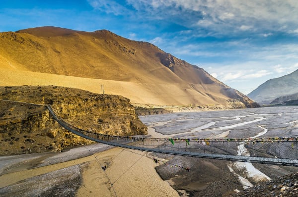
You land at Jomsom (2,700 m) in a landscape that looks nothing like the Nepal you left an hour ago: bare brown hillsides, a vast braided gravel riverbed, and almost no trees. The rest of the day is for settling in and acclimatising gently. The Mustang Eco Museum is a worthwhile hour. Overnight in Jomsom.
4Day 4Trek from Jomsom (2,700 m) to Kagbeni (2,800 m)
Trek from Jomsom (2,700 m) to Kagbeni (2,800 m)
An easy first walk of about three hours, deliberately short to let you adjust to the altitude and the wind.
The trail heads north along the wide gravel bed of the Kali Gandaki, mostly level. It is worth walking with your eyes down part of the time: this riverbed is the best-known source of shaligrams in the world — black spiral ammonite fossils weathering out of the Tethys seabed that was pushed up to form the Himalaya. Hindus revere them as manifestations of Vishnu, and they are found nowhere else in such numbers.
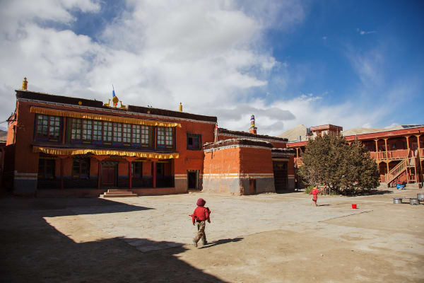
The wind rises through the morning and will be behind you heading north, which is a mercy. Kagbeni (2,800 m) appears as a sudden patch of green: a compact medieval village of mud-brick houses, covered alleyways you have to duck through, and a red-walled monastery, standing at the confluence of the Jhong Khola and the main river. It is the checkpoint for Upper Mustang. Overnight in Kagbeni.
5Day 5Trek from Kagbeni (2,800 m) to Muktinath (3,800 m)
Trek from Kagbeni (2,800 m) to Muktinath (3,800 m)
The main climbing day — a full kilometre of ascent from the river up into the Jhong Khola valley.
The trail leaves Kagbeni heading east and climbs steadily through wind-sculpted, almost lunar country. It passes the village of Khingar and then Jharkot (3,550 m), which deserves a stop: a ruined fort on a bluff above the trail, a red-walled Sakya monastery, and orchards of apple and apricot that are startlingly green against the bare hillsides.
A final pull brings you to Muktinath (3,800 m) in the afternoon. The Thorong La (5,416 m) comes down into the village from the north, so you will usually meet Annapurna Circuit trekkers arriving from the pass. Evening light on Dhaulagiri and Nilgiri to the south is the best view of the trek. Overnight in Muktinath.
6Day 6Visit Muktinath (3,800 m), Trek Back to Jomsom (2,700 m)
Visit Muktinath (3,800 m), Trek Back to Jomsom (2,700 m)
An early start at the temple complex, before the pilgrim buses arrive. Muktinath is one of very few Himalayan sites sacred to both Hindus and Buddhists — Mukti Kshetra, the place of liberation, one of the 108 Divya Desams of Vishnu; and Chumig Gyatsa, the hundred waters, associated with Guru Rinpoche.
Behind the main temple, spring water runs through 108 bull-headed spouts set in a curved wall, and pilgrims bathe beneath every one in sequence — a formidable undertaking in the cold at 3,800 m. In the Jwala Mai temple nearby, a natural gas flame burns above running spring water, fire and water together, which is why the site is held to be where all five elements meet.
We then begin the long descent, dropping through Jharkot and Khingar and down the Jhong valley to rejoin the Kali Gandaki, then south to Jomsom (2,700 m) with the wind full in our faces for the last stretch. Overnight in Jomsom.
7Day 7Drive from Jomsom (2,700 m) to Pokhara (822 m)
Drive from Jomsom (2,700 m) to Pokhara (822 m)
Rather than fly, this itinerary takes the road south — which is a genuinely rewarding day in its own right, and immune to the flight cancellations that Jomsom is prone to.
The jeep runs down the Kali Gandaki, and the transformation over the course of the journey is extraordinary. You start in bare high desert at Jomsom, pass the whitewashed Thakali village of Marpha (2,670 m) with its apple orchards, then Tukuche and Kalopani where the first pines appear. Below Ghasa the gorge narrows dramatically and the vegetation turns subtropical — you are dropping through the deepest part of the world's deepest canyon, between Dhaulagiri and Annapurna.
At Tatopani (1,200 m) there are natural hot springs beside the river, and the road then follows the Kali Gandaki and Modi Khola down to Beni and on to Pokhara (822 m). It is a long day on rough road for much of it. Overnight in Pokhara.
8Day 8Drive from Pokhara (822 m) to Kathmandu (1,400 m)
Drive from Pokhara (822 m) to Kathmandu (1,400 m)
A relaxed morning by the lake. If you are up early, sunrise over Annapurna and Machhapuchhre from the lakeside is worth it — you flew up the gorge between those peaks a few days ago. A rowing boat on Phewa Lake or the walk up to the World Peace Pagoda both fit before breakfast.
We then drive east on the Prithvi Highway to Kathmandu (1,400 m), following the Marsyangdi and Trishuli rivers back through the gorges. It is a full day with a lunch stop, arriving in the capital in the late afternoon.
After transferring to your hotel the evening is free — a hot shower, a good meal, and last-minute shopping in Thamel, where Marpha apple brandy is easy to find if you developed a taste for it. Overnight in Kathmandu.
9Day 9Final Departure from Kathmandu (1,400 m)
Final Departure from Kathmandu (1,400 m)
Your last day in Nepal. If your flight leaves later there is time for one more site in the valley. Pashupatinath, the great Shiva temple on the banks of the Bagmati, is the natural companion to a trek that visited Muktinath — both are among the most significant Hindu pilgrimage sites in the country. Boudhanath and Swayambhunath are both nearby.
Our representative collects you from your hotel and drives you to Tribhuvan International Airport around three hours before your scheduled departure.
The Jomsom Muktinath trek is short but takes in a remarkable amount: a flight between two eight-thousanders, the fossil beds of the Kali Gandaki, the medieval alleys of Kagbeni, and the 108 spouts and eternal flame at Muktinath. If the high desert appealed, Upper Mustang and the walled city of Lo Manthang are the obvious next trip. Safe travels.
Inclusions & Exclusions
The Pokhara-Jomsom flight, bus and jeep transport as per the itinerary, Kathmandu and Pokhara accommodation, teahouse lodging, all trekking meals, conservation area permits, a licensed guide, trekking map, first aid, and government taxes are included, while international flights, visa, insurance, personal gear, porter service, city meals, personal expenses, and tips are excluded.
What's Included
Airport pickup and drop-off services in Kathmandu.
Domestic flight from Pokhara to Jomsom as per the itinerary.
Tourist bus transportation from Kathmandu to Pokhara and back to Kathmandu.
Shared jeep transportation from Jomsom to Pokhara.
Accommodation in Kathmandu with breakfast.
Accommodation in Pokhara with breakfast.
Accommodation in local teahouses during the trek.
Annapurna Conservation Area Permit (ACAP) and required trekking permits.
Professional English-speaking licensed trekking guide.
Three meals a day (breakfast, lunch, and dinner) during the trek.
Group trekking map for route guidance.
First aid kit carried by the guide.
All government taxes, permit fees, and service charges.
What's Excluded
International flight tickets to and from Nepal.
Nepal entry visa fees.
Travel insurance, including emergency helicopter evacuation coverage.
Personal trekking equipment and clothing.
Porter services (available at an additional cost).
Lunch and dinner in Kathmandu and Pokhara.
Snacks, bottled water, hot showers, Wi-Fi, charging fees, and alcoholic or soft drinks.
Personal expenses such as laundry, phone calls, and souvenirs.
Tips for guides, drivers, and support staff.
Any additional accommodation, transportation, or expenses caused by domestic flight delays, bad weather, or other unforeseen circumstances beyond the itinerary.
Route Map
Explore the terrain map showing the trek route.
Loading map...
Altitude Profile
Pricing
Transparent per-person pricing based on group size, covering the services listed in the itinerary with no hidden charges.
Add-ons
Customize your trek with optional services such as porter support and other personalized arrangements at an additional cost.
Best Time to Trek
Because the Kali Gandaki sits in the Annapurna rain shadow, this trek has an unusually long season. March to May and September to November are the classic windows, with clear skies, moderate temperatures, and reliable flights. Autumn is best for visibility, spring for warmth and the apple harvest in Marpha later in the year.
Uniquely for Nepal, the trek also works during the monsoon (June to August), since the mountains block most of the rain and Mustang stays comparatively dry — though flights are more likely to be cancelled by cloud on the Pokhara side. Winter is cold and windy but walkable, with fewer visitors at Muktinath. The one constant is the valley wind, which picks up strongly from late morning every day of the year.
For a month-by-month look at weather and trail conditions, see our guide to the best time to trek in Nepal.
Altitude & Acclimatization
The flight from Pokhara to Jomsom lifts you from 830 m to 2,700 m in around twenty minutes, which is a substantial jump. The itinerary handles this by keeping the first walking days short and low — Jomsom to Kagbeni gains only 100 m — before the climb to Muktinath at 3,800 m.
Serious altitude illness is uncommon on this route, but mild headache in the first day or two after the flight is normal. Drink at least three litres of water a day, which matters more here than most places because the air is exceptionally dry, and take the climb to Muktinath at a steady pace. Your guide monitors the group and, if anyone is affected, descending to Jomsom resolves symptoms quickly. Sun protection is as important as altitude management in this landscape.
Prevention, symptoms and treatment are covered in depth in our guide to altitude sickness in Nepal.
Travel Insurance
Travel insurance covering trekking to at least 4,500 m is required, comfortably bracketing Muktinath at 3,800 m. Many standard policies extend this far, but check the altitude clause explicitly and confirm that domestic flights on small aircraft are covered, since the Pokhara-Jomsom sector is flown by turboprops into a short mountain strip.
Make sure the policy includes emergency helicopter evacuation, medical treatment, and — importantly on this route — cover for delayed or cancelled domestic flights. Jomsom flights are frequently grounded by wind and cloud, and the alternative is a long jeep journey down the Kali Gandaki. Send us your policy number and the insurer's emergency contact before departure.
Our guide to travel insurance for trekking in Nepal explains the altitude limits, evacuation terms and common exclusions to check before you buy.
Packing List
Mustang is dry, sunny, and extremely windy, which changes the packing priorities. Bring waterproof trekking boots, two or three base layers, a fleece, a light down jacket for Muktinath, and above all a proper windproof shell jacket and trousers — the afternoon wind in the Kali Gandaki is relentless. Add trekking trousers, a warm hat, a securely fitting sun hat, gloves, and wool socks. A sleeping bag rated to -5°C is sufficient.
Sun and dust protection matter more here than on most treks: high-SPF sunscreen, lip balm, wraparound sunglasses, and a buff or scarf for blowing dust are all essential. Also pack a 25-30 litre daypack, trekking poles, a headlamp, a reusable bottle with purification tablets or a filter, a good moisturiser for the dry air, a small first aid kit, quick-dry towel, toiletries, and a power bank.
For the complete kit list, organised by the altitude you will reach, see our Nepal trekking packing list.
Accommodation, Food & Drinking Water
You stay in tourist-standard hotels in Kathmandu and Pokhara and in teahouses at Jomsom, Kagbeni, and Muktinath. Lodges along the Kali Gandaki are among the most comfortable in Nepal thanks to road access — expect proper twin rooms, many with attached bathrooms, reliable hot showers, heated dining rooms, and in Jomsom and Kagbeni some genuinely good small hotels.
Three meals a day are included on the trek. Menus are broad, with dal bhat and free refills, Tibetan bread, momos, thukpa, noodles, fried rice, and pasta. Mustang is famous for its apples — Marpha in particular — which appear as fresh fruit, pies, juice, and the local apple brandy. Refill your bottle at the lodges and treat it with tablets, a filter, or a UV pen; the dry air means you will drink considerably more than you expect.
What the lodges are really like, from rooms and meals to showers and charging, is covered in our guide to teahouse trekking in Nepal.
Frequently Asked Questions
Find quick answers to common questions about the Jomsom Muktinath Trek.
1How many hours do we walk each day?
Three to six hours. This is a comparatively gentle trek — Jomsom to Kagbeni takes around three hours, Kagbeni to Muktinath four to five hours with a steady climb, and the return to Jomsom about five hours, mostly downhill along the river.
2Which permits are required and do you arrange them?
You need the Annapurna Conservation Area Permit and trekking registration. Both are included in your package and arranged by our team from passport copies and photographs sent before departure. Note that Kagbeni is the boundary — going north into Upper Mustang requires a separate restricted-area permit.
3What happens if the Jomsom flight is cancelled?
The Pokhara-Jomsom sector is frequently affected by wind and cloud, and flights operate almost exclusively in the early morning. If it is cancelled, the alternative is a long jeep journey up the Kali Gandaki, which takes most of a day. We recommend a spare day in your schedule.
4Why is the wind so strong in this valley?
The Kali Gandaki funnels air between Dhaulagiri and Annapurna, creating a powerful up-valley wind that begins around ten or eleven in the morning and blows hard all afternoon. This is why walking days start early and why flights only operate in the morning.
5Is this trek suitable for beginners or families?
Yes, and it is one of the better options for both. Walking days are short, lodges are comfortable, the maximum altitude is manageable, and there is a road for emergency evacuation for most of the route.
6Can I visit the Muktinath temple complex?
Yes, and it is the centrepiece of the trek. The complex is open to visitors of all faiths. Walk clockwise, remove shoes where indicated, and dress modestly. The 108 water spouts and the eternal flame chapel are the main sights, and pilgrims bathe under the spouts year round.
7Is mobile network and Wi-Fi available?
Coverage is good throughout, since the whole valley has road access and mains electricity. Lodges in Jomsom, Kagbeni, and Muktinath sell Wi-Fi and speeds are better than on most treks.
8Where can I withdraw cash and charge devices?
There is an ATM in Jomsom that is reasonably reliable, and charging is available at all lodges from mains power, often free. Even so, carry enough Nepalese rupees from Pokhara to cover the trek.
9How does the road affect the trekking experience?
A road now runs up the Kali Gandaki, and parts of the trail follow or cross it. Alternative walking paths exist on the eastern bank for much of the route and your guide will use them where possible, but you should expect to see jeeps and motorbikes on some sections.
10Can I leave extra luggage in Kathmandu or Pokhara?
Yes. Both hotels store anything you do not need on the trail free of charge until you return, which is worth doing given the strict baggage limits on the Jomsom flight.
Gallery
Explore authentic moments, landscapes, and mountain views from the Jomsom Muktinath Trek.
Trekking Guides & Articles
Jomsom Muktinath Trek: Pilgrimage and Desert in the Kali Gandaki — A trek behind the Himalaya into arid Mustang, through Marpha's apple orchards and the medieval village of Kagbeni to the pilgrimage temple at Muktinath.
Muktinath Pilgrimage Guide: The 108 Spouts and the Eternal Flame — A temple at 3,760 m sacred to both Hindus and Buddhists, with 108 water spouts and a natural gas flame burning over a spring.
The Tiji Festival at Lo Manthang: Three Days of Masked Dance — Each May, monks at Lo Manthang perform three days of masked dances enacting the defeat of a demon and the driving out of evil for the year.
Crossing Thorong La: The Biggest Day on the Annapurna Circuit — A 4 a.m.
Lower Mustang Trek: The Complete Guide — Ten days in the accessible half of Mustang — the walled medieval village of Kagbeni, a full day at the Muktinath temple complex, and the Thakali apple village of Marpha.
Upper Mustang Trek: The Walled Kingdom of Lo — A walled medieval capital at 3,840 m in a desert behind the Himalaya, with cave complexes, ochre cliffs and Tibetan Buddhism largely unchanged.
Fix Departure
This trek runs every week on the selected day. Choose custom dates for one-off departures.
Showing fixed departures in Oct 2026
Guest Reviews
A pilgrimage to remember
“The Jomsom Muktinath Trek was a deeply moving and beautifully organised experience. We felt welcomed everywhere we went and learned so much along the way. Beautifully organised and deeply rewarding.”
Lars Nelson
Get in Touch
Tell us the dates you have in mind and roughly what you want out of the trek — one of our guides will reply, usually within 24 hours.
Email Us
info@greencompasstreks.com
Call Us
+977 9864379436
Office
Lakeside, Pokhara, Nepal
Office Hours
Sunday – Friday, 9:00 AM – 9:00 PM
Similar Treks
You might also like these treks

Porter
$193 $175/porter
Flight from Kathmandu to Pokhara
$127 $115/person
Flight from Pokhara to Kathmandu
$127 $115/person
No payment required yet