

Humla Limi Valley Trek
The Humla Limi Valley Trek reaches the most isolated inhabited corner of Nepal, a Tibetan Buddhist enclave in the far no
Porter
$655 $595/porter
No payment required yet
Trip Overview
The Humla Limi Valley Trek reaches the most isolated inhabited corner of Nepal, a Tibetan Buddhist enclave in the far north-west that is closer to Mount Kailash than to any Nepali road. Two flights — Kathmandu to Nepalgunj, then Nepalgunj to Simikot (2,910 m) — deliver you to a district capital with no road link to the rest of the country at all.
From there the trail follows the Karnali toward the Tibetan border before turning east into the Limi Valley, where the three villages of Halji, Til, and Jang preserve a way of life and a form of Tibetan Buddhism that has changed remarkably little in centuries. Halji's Rinchenling Gompa dates from the eleventh century. Crossing the high pass at Talung (4,380 m) and the wild country around Manepeme, this 20-day journey is as remote as trekking in Nepal gets.
Trip Highlights
The Limi Valley Villages: Reach Halji, Til, and Jang, three Tibetan Buddhist settlements among the most isolated inhabited places in Nepal.
Rinchenling Gompa at Halji: Visit an eleventh-century monastery holding murals and manuscripts of exceptional age and importance.
The Tibetan Borderlands: Trek the Karnali corridor toward Hilsa and the old trading route to Mount Kailash.
High Passes and Wild Country: Cross Talung (4,380 m) and the remote terrain around Manepeme where snow leopard and blue sheep range.
Nepal's Most Isolated District: Fly into Simikot, a district capital with no road connection to the rest of the country.
Itinerary
A 20-day expedition into Nepal's most isolated district, flying to Simikot and trekking the Limi Valley villages of Halji, Til, and Jang with high camps and passes.
1Day 1Arrival in Kathmandu (1,400 m)
Arrival in Kathmandu (1,400 m)
You arrive at Tribhuvan International Airport in Kathmandu (1,400 m) and are met by our representative for the transfer to your hotel.
Your guide runs the pre-trek briefing. The Limi Valley trek in Humla is among the most remote journeys available in Nepal — a restricted region in the far north-west, culturally and geographically closer to Tibet than to Kathmandu, reached only by two flights and with no road access at all.
The logistics matter here. Humla has no road link to the rest of Nepal, so everything comes in by air or on the backs of animals, and the trek is fully supported with camping crew and pack animals for the high sections. Flights to Simikot are weather-dependent and delays are normal — the itinerary carries this in mind.
Your guide checks equipment carefully and arranges your restricted-area permit, which requires a registered agency and a minimum group size. The rest of the day is free. Overnight in Kathmandu.
2Day 2Fly from Kathmandu (1,400 m) to Nepalgunj (150 m)
Fly from Kathmandu (1,400 m) to Nepalgunj (150 m)
A short flight west to the Terai plains, positioning you for the early mountain flight tomorrow.
The hour-long flight leaves the Kathmandu valley and crosses the middle hills before descending over the flat, hot agricultural plain of the Terai. On a clear day the Himalayan chain is visible along the northern horizon for most of the journey — Ganesh Himal, Manaslu, Annapurna and Dhaulagiri in sequence.
Nepalgunj (150 m) is a busy border city close to India, and the climate is a shock after Kathmandu: hot, humid and low-lying. It is the aviation hub for the whole of western Nepal, and the only practical connection to Humla.
The afternoon is spent resting and preparing. If it is not too hot, the Bageshwori Temple is worth a visit, and the bazaar has a distinctly Indian character. Flights to Simikot leave at first light, so it is an early night. Overnight in Nepalgunj.
3Day 3Fly from Nepalgunj (150 m) to Simikot (2,910 m) and Trek to Dharapuri (2,270 m)
Fly from Nepalgunj (150 m) to Simikot (2,910 m) and Trek to Dharapuri (2,270 m)
A spectacular mountain flight followed by the first walking of the trek.
The morning flight to Simikot (2,910 m) is one of the most dramatic in Nepal — a small aircraft climbing from the plains over ridge after ridge of the western hills before landing on a short strip cut into a hillside. Flights go early because the wind rises later, and cancellations are common; patience is part of the trip.
Simikot is the administrative headquarters of Humla district, a town of a few thousand people with no road connecting it to anywhere. After meeting the crew and completing permit formalities, the trek begins.
The trail climbs briefly out of Simikot to a pass marked with prayer flags, then descends steadily through pine forest and terraced fields toward the Karnali river valley. Dharapuri (2,270 m) sits above the river. Around 3–4 hours of walking. Overnight camping at Dharapuri.
4Day 4Trek from Dharapuri (2,270 m) to Kermi (2,629 m)
Trek from Dharapuri (2,270 m) to Kermi (2,629 m)
A pleasant day following the Karnali upstream, gaining height gradually.
The trail runs along the north bank of the Karnali — Nepal's longest river, which rises in Tibet near Mount Kailash and cuts through this whole region. The walking is easy, undulating along the valley side through pine and birch forest, past terraced barley and buckwheat fields, and through small Hindu-influenced villages of the lower Humla.
This lower part of Humla is culturally distinct from the valley you are heading into: the villages here are largely Hindu, of Nepali-speaking Chhetri and Thakuri families, whereas the upper valleys are Tibetan Buddhist. The transition happens over the next two days.
Kermi (2,629 m) is a well-known stop for its two natural hot springs, a short walk from camp. After a day on the trail they are an excellent way to loosen up, and a rare luxury in a region this remote. Around 5 hours. Overnight camping at Kermi.
5Day 5Trek from Kermi (2,629 m) to Chumsa Khola Valley (3,400 m)
Trek from Kermi (2,629 m) to Chumsa Khola Valley (3,400 m)
A climbing day of nearly 800 m that leaves the Karnali and enters the high country.
The trail continues briefly along the Karnali before turning north into the side valley of the Chumsa Khola. The change is significant: you leave the relatively populated river corridor and start climbing into genuinely empty terrain.
The route ascends through pine and birch forest, crossing side streams on log bridges, before the trees begin to thin. Above around 3,000 m the vegetation becomes sparser and more alpine, and the valley narrows between steep rock walls. You pass the village of Chumsa and the last permanent habitation on this side.
Two Buddhist monasteries — at Lhundrup Ling near Kermi and along the way — mark the cultural shift as you climb: mani walls, chortens and prayer flags now line the trail.
Camp is in the open valley at around 3,400 m. Around 6 hours. Overnight camping in the Chumsa Khola valley.
6Day 6Trek from Chumsa Khola Valley (3,400 m) to Dharmashala (4,000 m)
Trek from Chumsa Khola Valley (3,400 m) to Dharmashala (4,000 m)
A steady climb of 600 m into high, treeless country beneath the first pass.
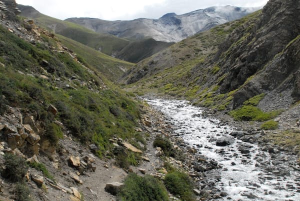
The trail follows the Chumsa Khola upstream through a narrowing valley of rock and scree. The last trees are left behind early in the day, and the landscape becomes entirely alpine — hardy grass, juniper scrub, boulder fields and the river running fast and cold below.
Progress slows with the altitude and the terrain, which is rough underfoot in places. Your guide sets a deliberately measured pace, since you will be sleeping at 4,000 m tonight and crossing higher ground tomorrow. Drink steadily through the day.
The mountains close in as you climb, with snow peaks appearing at the head of the valley. There are no settlements at all on this stretch — the only shelter is the one you are heading for.
Dharmashala (4,000 m) is a simple rest house or camping ground used by traders and pilgrims moving between Humla and Tibet. Around 5–6 hours. Overnight camping at Dharmashala.
7Day 7Trek from Dharmashala (4,000 m) to Talung (4,380 m)
Trek from Dharmashala (4,000 m) to Talung (4,380 m)
A short but demanding day at altitude, positioning you below the Nyalu La.
The distance is modest and the height gain under 400 m, but at this elevation both feel considerably harder than the numbers suggest. The itinerary keeps the day short deliberately: this is acclimatisation as much as progress.
The trail climbs over open, stony ground with no vegetation beyond lichen and the toughest alpine cushion plants. The valley is broad and bare, ringed by snow-covered peaks, and the sense of space is extraordinary — you can often see the entire day's walking ahead of you at once.
This is prime habitat for blue sheep, frequently spotted on the scree slopes, and the region is one of the strongholds of the snow leopard, though sightings are very rare. Himalayan griffon vultures ride the thermals overhead.
Talung (4,380 m) is an exposed camp with no shelter. Nights are cold and the air is thin. Around 3–4 hours. Overnight camping at Talung.
8Day 8Trek from Talung (4,380 m) to Jang (4,070 m)
Trek from Talung (4,380 m) to Jang (4,070 m)
The crossing of the Nyalu La (4,990 m), the highest point of the trek, followed by a descent into the Limi Valley.
This is the big day. The trail climbs steadily from Talung over increasingly barren ground to the pass, a slow ascent of around 600 m on scree and snow. The pace is necessarily slow, with frequent short stops.
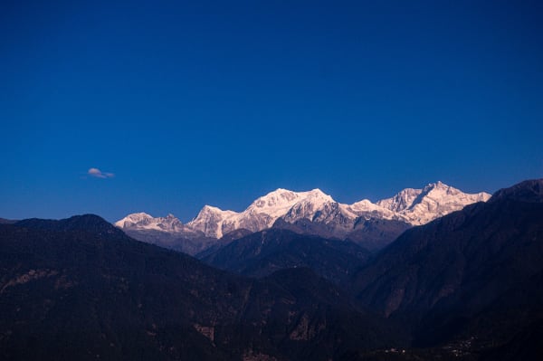
The Nyalu La is marked by cairns and prayer flags, and the view is one of the finest in western Nepal: north into Tibet, with the peaks of the Kailash range visible on a clear day, and south over the Humla ranges. It is bitterly cold and windy, so time at the top is short.
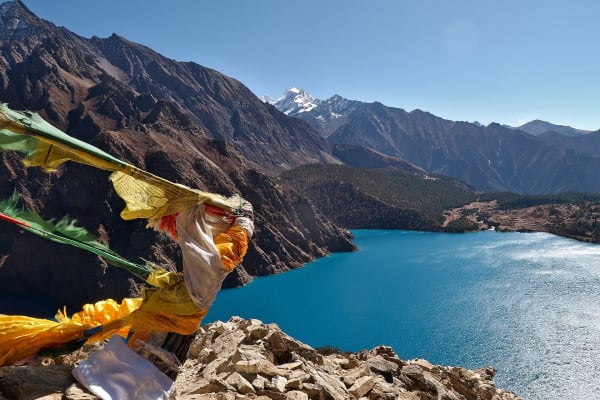
The descent passes the turquoise Selma Tso lake before dropping into the upper Limi Valley — the culturally Tibetan heart of the trek, home to just three villages.
Jang (4,070 m), also called Halji's neighbour Jang, is the first of them. 7–8 hours. Overnight camping at Jang.
9Day 9Acclimatization and Exploration Day in Jang (4,070 m)
Acclimatization and Exploration Day in Jang (4,070 m)
A rest day at 4,070 m after the pass, and a chance to spend real time in a Limi village.
The recommended approach is a gentle walk on the hillsides above the village rather than complete inactivity — a few hundred metres of climbing and back helps the body adjust more effectively than lying still. The ridges above Jang give wide views along the Limi Valley and north toward the Tibetan border.
The village itself is the more interesting part of the day. Jang is one of only three settlements in the Limi Valley, and its people are ethnically and culturally Tibetan — they speak a Tibetan dialect, follow the Drikung Kagyu school of Buddhism, and have historically traded across the border rather than south into Nepal. The houses are flat-roofed mud and stone, stacked close together against the wind, with firewood and fodder stored on the roofs.
Traditional crafts including wood carving and weaving are still practised here. Overnight camping at Jang.
10Day 10Trek from Jang (4,070 m) to Halji (3,670 m)
Trek from Jang (4,070 m) to Halji (3,670 m)
An easier day descending gently through the Limi Valley to its most significant village.
The trail follows the Limi Khola downstream on open, dry hillside. This is high-desert country in the rain shadow of the main Himalaya — brown and grey, with irrigation channels bringing snowmelt to small barley fields around each village, and almost no natural tree cover.
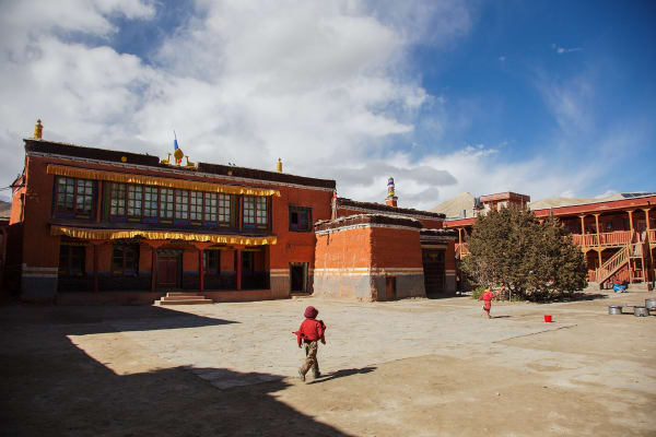
Halji (3,670 m) is the largest of the three Limi villages and the cultural centre of the valley. Its Rinchenling Gompa is the reason to be here: a monastery dating to roughly the 11th century, associated with the great translator Rinchen Zangpo, containing old murals, statues and manuscripts. It is one of the oldest surviving monasteries in the Nepal Himalaya and is still an active place of worship.
The village has been affected by glacial flooding in recent years, and you may see flood defences along the river.
Around 4–5 hours. Overnight camping at Halji.
11Day 11Trek from Halji (3,670 m) to Til (3,700 m)
Trek from Halji (3,670 m) to Til (3,700 m)
A short, level day to the last of the three Limi villages.
The walking is easy — barely any net height change — following the Limi Khola along the valley floor and lower slopes. The landscape is wide, dry and open, with eroded cliffs above and cultivated strips of barley and buckwheat wherever water can be channelled.
Til (3,700 m) is the smallest and most westerly of the Limi settlements, a tight cluster of flat-roofed houses built defensively close together, with a gompa and rows of chortens at the village entrance. Like Jang and Halji, its people are Tibetan Buddhist and its historic trade links run north over the border rather than south.
The short day leaves plenty of afternoon to spend in the village. This is one of the least-visited inhabited places in Nepal, and simply sitting and watching daily life — animals brought in, barley threshed by hand, wool spun on the doorstep — is the point.
Around 3 hours. Overnight camping at Til.
12Day 12Trek from Til (3,700 m) to Manepeme (3,970 m)
Trek from Til (3,700 m) to Manepeme (3,970 m)
The trek leaves the inhabited valley behind and enters a long, empty stretch of high country.
From Til the trail climbs away from the Limi Khola and traverses high above the river on an exposed path cut into steep hillsides. There are no villages ahead for two days — this is the most isolated section of the route, and everything you need is carried with you.
The walking is spectacular and at times airy, with long drops to the river below and the trail winding around spurs and side gullies. The landscape is entirely barren: rock, scree and dust, with the occasional juniper.
This stretch is good for wildlife precisely because nobody lives here. Blue sheep are frequently seen on the crags, along with Himalayan marmots, and the area lies within known snow leopard range.
Manepeme (3,970 m) is a camping ground beside a mani wall — the name refers to the carved prayer stones — with no permanent structures. Around 6–7 hours. Overnight camping at Manepeme.
13Day 13Trek from Manepeme (3,970 m) to Hilsa (3,740 m)
Trek from Manepeme (3,970 m) to Hilsa (3,740 m)
A long day crossing a final ridge and descending to the Nepal–Tibet border.
The trail climbs from camp over the Lamka La — a modest pass by the standards of this trek, but a stiff climb early in the morning — before beginning a long, sustained descent toward the Karnali.
The descent is steep and rough in places, dropping through dry gullies and eroded slopes with wide views north into Tibet. The mountains here are lower and more rounded than the peaks around the Nyalu La, and the country takes on the dusty, ochre character of the Tibetan plateau.
Hilsa (3,740 m) sits on the Karnali right at the border crossing into Tibet, and it is a strange place to arrive at after days of emptiness: a small settlement, a bridge across the river into China, and a steady flow of pilgrims heading for Mount Kailash and Lake Manasarovar. There is a helipad and, unusually for the region, a road on the Tibetan side.
6–7 hours. Overnight camping at Hilsa.
14Day 14Trek from Hilsa (3,740 m) to Palbang (3,389 m)
Trek from Hilsa (3,740 m) to Palbang (3,389 m)
The return leg begins, following the Karnali south-east back toward Simikot.
From Hilsa the trail crosses to the south side of the Karnali and climbs away from the river before contouring along the valley wall. The route from here back to Simikot is the historic trade and pilgrimage road between Humla and Tibet, used for centuries by traders moving salt, wool and grain, and today by Kailash pilgrims.
The walking is undulating rather than steadily downhill, with several climbs over spurs. The landscape remains dry and open, but as you move south and lose height, patches of juniper and scrub begin to appear again.
You pass through small settlements and past long mani walls and chortens, and you are likely to meet mule and yak trains on this stretch — the only way goods move in this region.
Palbang (3,389 m) is a small village on the route. Around 5–6 hours. Overnight camping at Palbang.
15Day 15Trek from Palbang (3,389 m) to Muchu (2,929 m)
Trek from Palbang (3,389 m) to Muchu (2,929 m)
A descending day of around 460 m back into greener, more populated country.
The trail continues along the Karnali valley, losing height steadily. The change in vegetation is noticeable through the day: the bare high-desert slopes give way first to juniper and scrub, then to birch and pine, and there is more running water and more cultivation.
This section passes through several villages, and the cultural mix shifts back — the upper settlements are Tibetan Buddhist, while lower down the influence becomes increasingly Hindu, the same transition you crossed on the way in, now in reverse.
Muchu (2,929 m) is a substantial village with a gompa above it and terraced fields around it, and it sits on the main trading route. There is a checkpoint here for the restricted area.
The warmer, thicker air at under 3,000 m is a noticeable relief after more than a week spent mostly above 3,700 m. Around 5 hours. Overnight camping at Muchu.
16Day 16Trek from Muchu (2,929 m) to Chumsa Khola (3,400 m)
Trek from Muchu (2,929 m) to Chumsa Khola (3,400 m)
A climbing day of around 470 m, rejoining the route walked on the way out.
The trail leaves Muchu and climbs steadily back up toward the Chumsa Khola, retracing the section you covered on day five but in the opposite direction and, usually, in different light and weather. Familiar ground looks quite different walked the other way, and with the trek nearly over there is more attention to spare for it.
The route follows the Karnali briefly before turning up into the side valley, climbing through pine and birch forest and past the terraced fields of the lower villages. The gradient is steady rather than severe.
By this stage you are thoroughly acclimatised, so a return to 3,400 m feels straightforward in a way it did not on the way out — a good measure of how much the body has adapted over two weeks.
Camp is in the open valley of the Chumsa Khola (3,400 m). Around 5–6 hours. Overnight camping at Chumsa Khola.
17Day 17Trek from Chumsa Khola (3,400 m) to Dharapuri (2,270 m)
Trek from Chumsa Khola (3,400 m) to Dharapuri (2,270 m)
A long descent of more than 1,100 m, back down to the Karnali river corridor.
The trail drops steadily out of the Chumsa Khola valley, through pine and birch forest and past the villages on the lower slopes, before rejoining the Karnali and following it downstream.
This is the last full day in the mountains, and the descent is a pleasure — the air thickens, temperatures rise, and after two weeks in largely barren high country the return of trees, birdsong and running irrigation channels is genuinely striking.
The lower Humla villages here are Hindu, with a different architecture and a different rhythm to the Tibetan settlements of the Limi Valley, and the contrast between the two halves of the trek is at its clearest on this stretch.
Dharapuri (2,270 m), where you camped on the first night of walking, closes the loop. Around 6 hours. Overnight camping at Dharapuri.
18Day 18Trek from Dharapuri (2,270 m) to Simikot (2,910 m)
Trek from Dharapuri (2,270 m) to Simikot (2,910 m)
The final walking day, climbing back up to the airstrip town where the trek began.
The trail leaves the Karnali and climbs steadily through terraced fields and pine forest, gaining around 640 m to the pass above Simikot — a stiff final ascent, but a short one, and by now entirely within your capacity.
From the prayer-flagged pass there is a last long view back over the Humla ranges and the country you have crossed, before the short descent into town.
Simikot (2,910 m) feels almost metropolitan after the Limi Valley: shops, a few lodges, mobile signal and the airstrip. It is a good place to settle up with the camping crew and the animal handlers, who will be heading back to their villages from here.
The rest of the afternoon is free. Given that flights out are entirely weather-dependent and delays are routine, a relaxed evening and an early night are the sensible plan. Around 4–5 hours. Overnight in Simikot.
19Day 19Fly from Simikot (2,910 m) to Nepalgunj (150 m) and Kathmandu (1,400 m)
Fly from Simikot (2,910 m) to Nepalgunj (150 m) and Kathmandu (1,400 m)
Two flights in one day, returning from the far west to the capital.
The morning flight from Simikot leaves early, before the wind picks up, and gives a final aerial view of the Humla ranges — a chance to see the whole geography of the trek at once, the Karnali cutting its valley and the high country beyond.
It is worth repeating that this flight is weather-dependent. Cancellations and delays of a day or more are a normal part of travel in Humla, which is why a buffer day at the end of a trip here is always sensible.
At Nepalgunj (150 m) you connect to the onward flight to Kathmandu, dropping from mountain air into the heat of the Terai and then back up to the valley.
You arrive in Kathmandu (1,400 m) and transfer to your hotel. After nearly three weeks of camping, the shower is memorable. The evening is free. Overnight in Kathmandu.
20Day 20Final Departure from Kathmandu (1,400 m)
Final Departure from Kathmandu (1,400 m)
The last day of the Humla Limi Valley Trek.
Depending on your flight there may be free time in the morning. Thamel is the obvious stop for last-minute shopping, and if you have half a day the Buddhist sites of Boudhanath and Swayambhunath connect directly to what you have just seen — the Tibetan Buddhist culture of the Limi Valley in its urban, pilgrimage form.
Our representative collects you from your hotel and transfers you to Tribhuvan International Airport around three hours before departure.
You leave having completed one of the most remote treks in Nepal: over the Nyalu La (4,990 m), through the three Tibetan villages of the Limi Valley, to the Tibetan border at Hilsa and back along the old salt-trade road — through a district with no roads, few visitors, and a culture that has changed very little.
Inclusions & Exclusions
All domestic flights, Kathmandu and Nepalgunj accommodation, village and tented lodging, all trekking meals, the Humla Restricted Area Permit, a licensed guide, camp crew, trekking map, first aid, and government taxes are included, while international flights, visa, insurance, personal gear, porter service, city meals, personal expenses, and tips are excluded.
What's Included
Airport pickup and drop-off services in Kathmandu.
Domestic flights from Kathmandu to Nepalgunj, Nepalgunj to Simikot, Simikot to Nepalgunj, and Nepalgunj to Kathmandu.
Accommodation in Kathmandu with breakfast.
Accommodation in Nepalgunj with breakfast.
Accommodation in local teahouses during the trek.
Humla Restricted Area Permit and required trekking permits.
Professional English-speaking licensed trekking guide.
Three meals a day (breakfast, lunch, and dinner) during the trek.
Group trekking map for route guidance.
First aid kit carried by the guide.
Tented accommodation and a full camp and kitchen crew for the sections without permanent shelter.
All government taxes, permit fees, and service charges.
What's Excluded
International flight tickets to and from Nepal.
Nepal entry visa fees.
Travel insurance, including emergency helicopter evacuation coverage.
Personal trekking equipment and clothing.
Porter services (available at an additional cost).
Lunch and dinner in Kathmandu and Nepalgunj.
Snacks, bottled water, hot showers, Wi-Fi, charging fees, and alcoholic or soft drinks.
Personal expenses such as laundry, phone calls, and souvenirs.
Tips for guides, drivers, and support staff.
Any additional accommodation, transportation, or expenses caused by domestic flight delays, bad weather, or other unforeseen circumstances beyond the itinerary.
Route Map
Explore the terrain map showing the trek route.
Loading map...
Altitude Profile
Pricing
Transparent per-person pricing based on group size, covering the services listed in the itinerary with no hidden charges.
Add-ons
Customize your trek with optional services such as porter support and other personalized arrangements at an additional cost.
Best Time to Trek
Humla lies deep in the Himalayan rain shadow, which gives it a distinctive season. May to early October is the workable window, and unusually for Nepal this includes the monsoon months, when the region stays comparatively dry while the rest of the country is under rain. June to September is in fact the most reliable period for the high passes.
Spring before May is often still snow-bound on the Limi passes, and from late October the valley begins to close in for winter — by November the passes are blocked, the Limi villagers move their livestock, and flights to Simikot become unreliable. December to April is not feasible for this route.
For a month-by-month look at weather and trail conditions, see our guide to the best time to trek in Nepal.
Permits & Regulations
Humla is a restricted area and entry is tightly controlled. You need the Humla Restricted Area Permit, issued only through a registered trekking agency, currently USD 50 per person per week for the first week and USD 10 per day thereafter, alongside standard trekking registration. Permits are non-transferable and are checked at Simikot and again near the border.
Regulations require a minimum of two trekkers travelling together and a licensed guide throughout — solo trekking is not permitted. Because the route runs close to the Tibetan frontier, border formalities are taken seriously and you should carry your passport at all times. Our team handles the full application, but we need clear passport copies, passport photographs, and your Nepal visa details well in advance; these permits cannot be arranged at short notice.
The fees and conditions for every restricted area are set out in our guide to restricted area permits in Nepal.
Travel Insurance
Travel insurance covering trekking to at least 5,000 m is mandatory for this trek, and it needs to be a policy that genuinely covers remote-area expedition travel rather than standard holiday cover. Read the altitude clause and the remoteness exclusions carefully before purchasing.
Emergency helicopter evacuation and repatriation cover is critical here in a way it is not on more accessible routes. There is no road anywhere in Humla, no hospital, and from the Limi Valley the nearest meaningful medical facility is a flight and a drive away. Helicopter operators require a guarantee of payment before dispatching, and the flying distances are long and expensive. Also ensure the policy covers delayed or cancelled domestic flights, since the Nepalgunj-Simikot sector is frequently grounded. Send us your policy number and the insurer's 24-hour emergency line well before departure.
Our guide to travel insurance for trekking in Nepal explains the altitude limits, evacuation terms and common exclusions to check before you buy.
Altitude, Remoteness & Safety
The itinerary includes an acclimatization and exploration day at Jang (4,070 m) and builds altitude gradually from Simikot through Dharapuri and Kermi, but the trek spends the better part of two weeks above 3,400 m with a high point around Talung at 4,380 m. Your guide monitors the group each evening and the pace is deliberately unhurried.
Remoteness is the defining risk rather than altitude. There are no lodges of any size, no shops, no medical posts, and no road for the entire route, and evacuation is slow and complicated even by Nepali standards. That means we plan conservatively: extra food and fuel are carried, the schedule has slack built in, and your guide carries a satellite communication device. Trekkers should be honest with themselves about fitness and health before booking, since there is no easy exit halfway.
Prevention, symptoms and treatment are covered in depth in our guide to altitude sickness in Nepal.
Accommodation, Food & Drinking Water
Accommodation alternates between very simple village homestays and lodges in Simikot, Dharapuri, Kermi, Halji, Til, and Jang, and tented camps at Chumsa Khola, Dharmashala, Talung, and Manepeme where there is no permanent shelter at all. A full camp and kitchen crew supports the tented sections. Conditions are basic throughout — no hot showers outside Simikot, limited washing water, and shared or outdoor toilets in the villages.
Three meals a day are included on the trek. In the villages you eat what households cook, which in Humla means tsampa, barley and buckwheat dishes, potatoes, dal bhat where rice is available, and butter tea. At the camps our kitchen crew cooks for the group from supplies carried in. Dietary requirements must be told to us well in advance, since everything is purchased before the trek and nothing can be bought en route. Water comes from streams and springs and must be treated throughout.
Frequently Asked Questions
Find quick answers to common questions about the Humla Limi Valley Trek.
1How many hours do we walk each day?
Six to eight hours on most days, on rough trails with significant daily ascent and descent. The crossings toward Talung and the long stages around Manepeme and Hilsa are the most demanding, running eight to ten hours.
2How reliable are the flights to Simikot?
Not very. The Nepalgunj-Simikot sector is a small aircraft operating into a mountain airstrip and is regularly cancelled for weather or aircraft availability. Delays of one to three days happen, which is why the itinerary includes buffer and why spare days at the end of your trip are strongly advised.
3Can I trek Humla alone?
No. Restricted-area regulations require a minimum of two trekkers on a permit and a licensed guide throughout. If you are travelling solo we can pair you with another trekker on a fixed departure or issue a two-person permit at the corresponding cost.
4Do we camp or stay in villages?
Both. Simikot and the Limi villages have basic homestays and lodges, but the sections between them — Chumsa Khola, Dharmashala, Talung, and Manepeme — have no permanent shelter, so the group camps with a full crew for roughly half the nights.
5Why is Halji's monastery significant?
Rinchenling Gompa at Halji dates from the eleventh century and holds murals, statues, and manuscripts of considerable age and scholarly importance. It is one of the oldest continuously active monasteries in the Nepali Himalaya and is treated with real reverence by the Limi community.
6Can I see Mount Kailash from the route?
The trail approaches the Tibetan border near Hilsa, historically the trading route toward Kailash and Lake Manasarovar, and on a clear day parts of the Tibetan plateau are visible. Kailash itself lies inside Tibet and is not part of this itinerary — crossing the border requires a Chinese visa and separate permits.
7Is mobile network available?
There is limited coverage at Simikot and effectively none for the rest of the route. Expect to be entirely offline for two weeks or more. Our guides carry a satellite communication device for emergencies and can send brief messages if genuinely needed.
8Where can I withdraw cash and charge devices?
There is no reliable ATM in Simikot and none beyond it. Carry all your Nepalese rupees from Kathmandu or Nepalgunj for the entire trip. Charging is solar and very limited in the villages and unavailable at camps, so bring a large power bank and spare batteries.
9What wildlife might we see?
The Limi Valley is important snow leopard habitat, though sightings are extremely rare. Blue sheep, Himalayan wolf, marmot, lammergeier, and Himalayan griffon are seen much more often, and the valley is one of the better places in Nepal for high-altitude wildlife.
10Can I leave extra luggage in Kathmandu?
Yes, and you should. Your Kathmandu hotel stores anything you do not need free of charge until you return, which matters given the strict baggage limits on the Simikot flight and the weight constraints of a camping trek.
Gallery
Explore authentic moments, landscapes, and mountain views from the Humla Limi Valley Trek.
Trekking Guides & Articles
Humla Limi Valley Trek: The Complete Guide — Twenty days in the most isolated inhabited corner of Nepal — a Tibetan Buddhist enclave closer to Mount Kailash than to any Nepali road.
Api Himal Expedition: The Complete Guide — The highest mountain in far-western Nepal and the most remote 7,000 m peak in the country — a few kilometres from both the Indian and Tibetan borders.
Fix Departure
This trek runs every week on the selected day. Choose custom dates for one-off departures.
Showing fixed departures in Oct 2026
Guest Reviews
The best trekking experience yet
“I have done a few Himalayan treks and this one stands out for all the right reasons. Our guide was fantastic — knowledgeable about the mountains, the culture and exactly when we needed a break. Our po...
Hannah King
Get in Touch
Tell us the dates you have in mind and roughly what you want out of the trek — one of our guides will reply, usually within 24 hours.
Email Us
info@greencompasstreks.com
Call Us
+977 9864379436
Office
Lakeside, Pokhara, Nepal
Office Hours
Sunday – Friday, 9:00 AM – 9:00 PM
Similar Treks
You might also like these treks
Porter
$655 $595/porter
No payment required yet