

Kanchenjunga Circuit Trek
The Kanchenjunga Circuit Trek is the definitive expedition-scale trek in eastern Nepal, linking both base camps of Kanch
Porter
$616 $560/porter
No payment required yet
Trip Overview
The Kanchenjunga Circuit Trek is the definitive expedition-scale trek in eastern Nepal, linking both base camps of Kanchenjunga (8,586 m) — the world's third-highest mountain — in a single 21-day journey. The route flies to Bhadrapur, drives up through the tea gardens of Ilam to Taplejung, and walks north up the Tamor valley through subtropical forest into high glacial country.
The northern arm reaches Pangpema (5,143 m) beneath the immense north face, then crosses the Sele La ridge system to the southern side for the Oktang viewpoint above the Yalung Glacier. Between them lie the Sherpa village of Ghunsa, the high camps at Kambachen and Lhonak, and some of the least visited high country in Nepal. This is a restricted region and a genuinely remote undertaking.
Trip Highlights
Both Kanchenjunga Base Camps: Reach Pangpema (5,143 m) on the north side and the Oktang viewpoint above the Yalung Glacier on the south.
Cross the Sele La Ridge: Link the two sides of the massif over a series of high passes rather than driving around.
Ghunsa and the Upper Tamor: Stay in a traditional Sherpa village at 3,415 m at the heart of the Kanchenjunga Conservation Area.
Tea Gardens to Glaciers: Travel from the tea estates of Ilam through subtropical forest to high glacial moraine in one journey.
A Restricted, Rarely Walked Region: Trek permit-controlled country that receives a tiny fraction of the visitors of Everest or Annapurna.
Itinerary
A 21-day restricted-area circuit linking both Kanchenjunga base camps — Pangpema (5,143 m) and Oktang — over the Sele La ridge, with an acclimatization day at Ghunsa.
1Day 1Arrival in Kathmandu (1,400 m)
Arrival in Kathmandu (1,400 m)
You arrive at Tribhuvan International Airport in Kathmandu (1,400 m) and are met by our representative for the transfer to your hotel.
Your guide runs the pre-trek briefing. The Kanchenjunga Circuit is one of the longest and most committing teahouse treks in Nepal — a three-week journey to both base camps of Kanchenjunga (8,586 m), the world's third-highest mountain, linked by the high passes of the Sele La.
It is a restricted area, requiring a special permit, a registered agency and a minimum of two trekkers. It is also genuinely remote: the region sees a small fraction of the traffic of Everest or Annapurna, lodges are basic and sometimes sparse, and the approach alone takes three days of flying and driving.
Your guide checks your equipment. This trek needs a proper four-season sleeping bag and full cold-weather layers — you will sleep at 4,792 m and cross passes above 4,600 m. The rest of the day is free. Overnight in Kathmandu.
2Day 2Fly from Kathmandu (1,400 m) to Bhadrapur (91 m)
Fly from Kathmandu (1,400 m) to Bhadrapur (91 m)
A short flight to the far south-eastern corner of Nepal, the first leg of the long approach.
The 45-minute flight crosses the middle hills and descends over the Terai plains. On a clear day the views north are exceptional — the eastern Himalaya laid out along the horizon, with Kanchenjunga itself often visible as the massif furthest east, giving you a first sight of the mountain you will spend the next fortnight walking toward.
Bhadrapur (91 m) sits close to the Indian border in Jhapa district, and the change from Kathmandu is total: flat, hot, humid and green, with paddy fields and tea gardens rather than terraced hillsides.
The remainder of the day is spent resting and preparing for the long drive north. It is worth taking the heat and humidity as a novelty — within four days you will be wearing everything you own. Overnight in Bhadrapur.
3Day 3Drive from Bhadrapur (91 m) to Taplejung (1,820 m)
Drive from Bhadrapur (91 m) to Taplejung (1,820 m)
A long day on the road, climbing from the plains into the eastern hills.
The drive covers around 200 km but takes most of the day, as the road leaves the flat Terai and begins winding up into the hills of Ilam district. This is Nepal's tea country, and the hillsides are covered in neatly clipped tea gardens — an unusual and very green landscape by Nepali standards.
Beyond Ilam the road climbs steadily through subtropical forest, small bazaars and terraced farmland, gaining more than 1,700 m over the course of the journey. The surface deteriorates as you go north and the driving is slow, with switchbacks and steep drops.
Taplejung (1,820 m) is the district headquarters and the last town of any size before the mountains. On a clear afternoon there are first proper views of the Kanchenjunga range from the ridge above town. Overnight in Taplejung.
4Day 4Drive from Taplejung (1,820 m) to Sekathum (1,650 m)
Drive from Taplejung (1,820 m) to Sekathum (1,650 m)
A short distance on a rough road, reaching the trailhead where the walking finally begins.
The drive from Taplejung follows the valley of the Tamor River north on a narrow, unsealed road cut into steep hillsides. It is only a few dozen kilometres but takes several hours — the surface is poor, landslide damage is common, and the road frequently narrows to a single track above a substantial drop. A 4WD jeep is essential.
The route passes through Mitlung and Chirwa, small roadside settlements serving the valley, with terraced cardamom plantations on the slopes. Cardamom is the cash crop of this region and you will see it drying beside houses throughout the lower valley.
Sekathum (1,650 m) sits at the confluence of the Ghunsa and Simbuwa rivers — the two valleys that form the two halves of this circuit. Overnight in Sekathum.
5Day 5Trek from Sekathum (1,650 m) to Amjilasa (2,510 m)
Trek from Sekathum (1,650 m) to Amjilasa (2,510 m)
The first walking day, and a demanding one — a climb of around 860 m through steep, forested gorge country.
The trail follows the Ghunsa Khola north, crossing the river several times on suspension bridges. The valley here is a deep, narrow, subtropical gorge, thick with vegetation and loud with the river below.
The day's character is set by the final section: a long, sustained, steep climb up the valley wall on a trail that switchbacks relentlessly. It is hot work at this altitude and in this humidity, and it is a genuine introduction to the effort this trek requires.
The forest is superb — bamboo, ferns, orchids and hanging moss, with butterflies and excellent birdlife. Landslides are common in this terrain and the trail is occasionally rerouted around fresh damage.
Amjilasa (2,510 m) is a tiny settlement perched high on the hillside. Around 6–7 hours. Overnight in Amjilasa.
6Day 6Trek from Amjilasa (2,510 m) to Gyabla (2,725 m)
Trek from Amjilasa (2,510 m) to Gyabla (2,725 m)
A short day in net height gain but a strenuous one in profile, with repeated climbs and descents.
The net gain is only around 200 m, but the trail spends the day rising and falling across a series of steep side valleys, and the actual ascent and descent is considerably more than the figures suggest. This is characteristic of the Ghunsa valley, where the path traverses high above the river rather than following it.
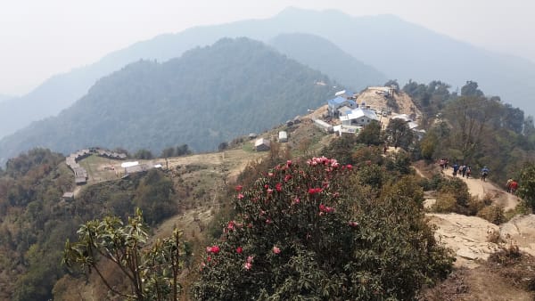
The forest changes noticeably as you climb — the subtropical bamboo and ferns of the lower gorge give way to rhododendron, oak and, higher up, the first conifers. In spring this section is spectacular, with the rhododendrons in flower across the whole hillside.
There are waterfalls along the route and occasional openings in the canopy with views up the valley toward the snow peaks.
Gyabla (2,725 m), also called Kyapra, is a small Tibetan-influenced village in a clearing. Around 5–6 hours. Overnight in Gyabla.
7Day 7Trek from Gyabla (2,725 m) to Ghunsa (3,415 m)
Trek from Gyabla (2,725 m) to Ghunsa (3,415 m)
A steady climb of around 690 m into the main village of the northern valley.
The trail continues north through pine and fir forest, following the Ghunsa Khola upstream. The gradient is gentler than the previous days and the valley begins to open out, with the first clear views of snow-covered peaks at its head.
Partway along you pass Phale (3,140 m), a settlement founded by Tibetan refugees who crossed the border in the 1960s. There is a small gompa and a carpet-weaving and handicraft workshop, and it is a good place to stop — the community here has a distinct history and is usually happy to talk about it.
Ghunsa (3,415 m) is the largest permanent settlement on the northern side of the circuit, a proper village of wooden and stone houses with a monastery, a health post and a micro-hydro scheme.
Around 5 hours. Overnight in Ghunsa.
8Day 8Acclimatization Day in Ghunsa (3,415 m)
Acclimatization Day in Ghunsa (3,415 m)
An essential rest day at 3,415 m before the serious altitude of the coming week.
This is not a day off so much as an active recovery day. The principle is to climb high and sleep low, so the recommendation is a hike of several hundred metres above the village and back — options include the ridge to the north for views up the Ghunsa valley, or a walk toward the Yamatari glacier viewpoint.
Ghunsa itself deserves time. It is the administrative and cultural centre of the upper valley, with a Tibetan Buddhist monastery, long mani walls and prayer wheels along the main path. The population is largely of Tibetan origin and the village has a strong sense of its own identity.
There is also a memorial here to the conservationists and officials killed in a 2006 helicopter crash while working on the Kanchenjunga Conservation Area.
Rest well, eat properly and hydrate — from here the trek climbs hard. Overnight in Ghunsa.
9Day 9Trek from Ghunsa (3,415 m) to Kambachen (4,145 m)
Trek from Ghunsa (3,415 m) to Kambachen (4,145 m)
A climb of 730 m out of the forest and into high alpine terrain.
The trail leaves Ghunsa and climbs steadily north through the last of the pine and birch forest before breaking out above the treeline. The transformation over a single morning is dramatic — from enclosed woodland to open, stony country with glaciers visible ahead.
The route follows the river past Rambuk Kharka, a summer grazing ground, and then crosses a section of unstable scree below a waterfall. This landslide-prone traverse requires care and is best crossed steadily, without stopping.
As you gain height, Jannu (7,710 m) — known locally as Kumbhakarna — comes into view, one of the most dramatic mountain profiles in Nepal, a sheer and forbidding wall of rock and ice.
Kambachen (4,145 m) is a small seasonal settlement of stone huts in a bare valley. The altitude is felt here. Around 5–6 hours. Overnight in Kambachen.
10Day 10Trek from Kambachen (4,145 m) to Lhonak (4,792 m)
Trek from Kambachen (4,145 m) to Lhonak (4,792 m)
A hard day at altitude, gaining nearly 650 m into a glacial basin at close to 4,800 m.
The trail climbs from Kambachen across boulder fields and moraine, following the north side of the valley. The terrain is rough and the going slow, with a further section of loose scree to traverse early in the day.
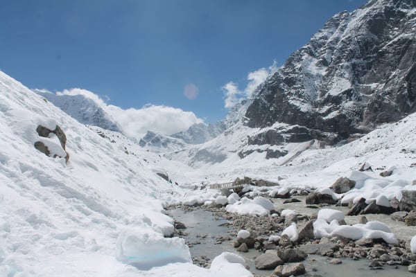
The landscape here is entirely glacial — the vegetation gives out almost completely, and the walking is on rock, ice-scoured slabs and the debris of the Kanchenjunga Glacier. The scale is difficult to convey: the valley is broad and grey, walled by peaks over 7,000 m.
Jannu (7,710 m) dominates the view behind you for much of the ascent, and ahead the peaks around Kanchenjunga begin to appear.
Lhonak (4,792 m) is a bare, exposed settlement of a few stone lodges on a sandy plain beside the glacier. Nights here are very cold and sleep is often broken by the altitude. Around 4–5 hours. Overnight in Lhonak.
11Day 11Trek from Lhonak (4,792 m) to Kanchenjunga North Base Camp (5,143 m) and Back to Lhonak (4,792 m)
Trek from Lhonak (4,792 m) to Kanchenjunga North Base Camp (5,143 m) and Back to Lhonak (4,792 m)
The northern climax of the trek: a day hike to Pangpema (5,143 m), the north base camp of Kanchenjunga.
You set out early with a light pack. The trail climbs gradually along the lateral moraine of the Kanchenjunga Glacier, gaining around 350 m over several hours. The gradient is not severe, but at close to 5,000 m the pace is necessarily slow.
Pangpema is a flat grassy shelf overlooking the glacier, and the view is one of the great sights of the Himalaya: the entire north face of Kanchenjunga (8,586 m) rising more than 3,000 m directly in front of you, flanked by Wedge Peak, the Twins and Tent Peak. There is nothing between you and the wall.
Those feeling strong can climb the ridge behind base camp for an even wider panorama.
After time at the top you return along the same route to Lhonak. Around 6–7 hours in total. Overnight in Lhonak.
12Day 12Trek from Lhonak (4,792 m) to Ghunsa (3,415 m)
Trek from Lhonak (4,792 m) to Ghunsa (3,415 m)
A long descent of nearly 1,400 m, retracing the northern valley back to Ghunsa in a single day.
The route reverses the approach — down past Kambachen, across the scree traverses, and back below the treeline. Descending covers ground far more quickly than the climb did, and it is a long but satisfying day.
The physiological effect is immediate and welcome. After several nights above 4,100 m, dropping to 3,415 m means thicker air, warmer temperatures and, almost always, a much better night's sleep. Appetite tends to return sharply too.
There is time to appreciate the valley in the other direction: Jannu stays in view behind for much of the morning, and the return of juniper, then birch, then pine forest through the day marks the descent as clearly as any altimeter.
Back at Ghunsa (3,415 m), this is the last comfortable night before the pass crossings that link the two halves of the circuit. Around 6–7 hours. Overnight in Ghunsa.
13Day 13Trek from Ghunsa (3,415 m) to Sele La Camp (4,240 m)
Trek from Ghunsa (3,415 m) to Sele La Camp (4,240 m)
A steep climb of over 800 m to a high camp beneath the passes — the start of the crossing to the southern side.
The trail leaves Ghunsa and climbs immediately and steeply through dense rhododendron and juniper forest on the western wall of the valley. There is no gradual start to this day; it is uphill from the village.
Above the treeline the route emerges onto open alpine slopes with wide views back across the Ghunsa valley toward Jannu and the peaks you visited from Lhonak.
Sele La Camp (4,240 m) — also called Selele — is a small, exposed group of huts on a bare shelf. Facilities are minimal, water can be scarce, and it is often the coldest night of the trek.
This is the staging point for tomorrow's crossing, which takes in several passes in succession. Prepare kit tonight, eat well and get what sleep you can. Around 5–6 hours. Overnight at Sele La Camp.
14Day 14Trek from Sele La Camp (4,240 m) to Cheram (3,870 m)
Trek from Sele La Camp (4,240 m) to Cheram (3,870 m)
The crux of the circuit: a long, high crossing over a series of passes into the Yalung valley.
This is the day that links the two halves of the trek, and it is the most demanding. The route crosses not one pass but several in succession — the Sele La, Mirgin La (4,480 m), Sinion La and Tamo La — each with its own climb and descent, so the day involves far more ascent than the net figures suggest.
The terrain is high, open and completely exposed, with no shelter for hours at a time. In poor weather or fresh snow this crossing is serious, and it is entirely weather-dependent.
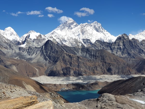
The compensation is the view. From the passes, in clear conditions, the panorama takes in Kanchenjunga, Jannu, Makalu and, far to the west, Everest and Lhotse.
A long descent brings you to Cheram (3,870 m) in the Yalung valley. 7–9 hours. Overnight in Cheram.
15Day 15Trek from Cheram (3,870 m) to Ramche (4,580 m)
Trek from Cheram (3,870 m) to Ramche (4,580 m)
A climb of around 700 m up the Yalung valley toward the southern base camp area.
The trail leaves Cheram and climbs alongside the Yalung Glacier, following its lateral moraine up the valley. The walking is on open ground with no tree cover, and the valley is broad, stony and increasingly dramatic as you gain height.
The pace is deliberately steady — you are climbing back above 4,500 m after a night lower down, and although you are well acclimatised by this stage of the trek, the altitude still requires respect.
The peaks around the head of the valley come progressively into view: Rathong, Kabru and the southern outliers of the Kanchenjunga massif, with the glacier grinding below.
Ramche (4,580 m) is a small settlement of lodges in a high meadow beside the glacier, with a small lake nearby and blue sheep often grazing on the surrounding slopes. Around 4–5 hours. Overnight in Ramche.
16Day 16Hike from Ramche (4,580 m) to Oktang Viewpoint (4,730 m) and Back to Ramche (4,580 m)
Hike from Ramche (4,580 m) to Oktang Viewpoint (4,730 m) and Back to Ramche (4,580 m)
The southern climax of the trek: a day hike to the Oktang viewpoint beneath the south face of Kanchenjunga.
You set out early with a light pack for the relatively short climb of around 150 m up the Yalung Glacier moraine. The walking is straightforward by the standards of this trek, and the altitude is by now familiar.
Oktang (4,730 m) is a viewpoint marked by chortens and prayer flags, and it faces the immense south face of Kanchenjunga (8,586 m). The wall here is one of the largest mountain faces on earth, with Yalung Kang, Kabru and Rathong around it and the glacier running away below.
Having now seen the mountain from both its northern and southern base camps, the scale of the massif becomes properly comprehensible — the two viewpoints are separated by a week of walking and several 4,000 m passes.
Return to Ramche. Around 5–6 hours. Overnight in Ramche.
17Day 17Trek from Ramche (4,580 m) to Tortang (2,995 m)
Trek from Ramche (4,580 m) to Tortang (2,995 m)
A very long descent of nearly 1,600 m, dropping out of the high country and back into forest.
The trail retraces the Yalung valley down past Cheram and then continues below it into terrain you have not yet walked. The descent is sustained and hard on the knees — trekking poles are worth using throughout.
The change in environment over the course of the day is one of the most striking of the trek. You start on bare glacial moraine above 4,500 m and finish in dense, humid rhododendron and bamboo forest under 3,000 m, passing through juniper scrub, birch and conifer on the way.
The oxygen, warmth and greenery all arrive together, and after two weeks at altitude the effect is remarkable. Birdsong returns; so does the smell of vegetation.
Tortang (2,995 m) is a small settlement in the forest beside the Simbuwa Khola. Around 6–7 hours. Overnight in Tortang.
18Day 18Trek from Tortang (2,995 m) to Sekathum (1,650 m)
Trek from Tortang (2,995 m) to Sekathum (1,650 m)
The final walking day of the circuit, descending through forest and gorge to close the loop at the trailhead.
The trail continues down the Simbuwa Khola valley, losing height steadily through thick subtropical forest. This is lush, warm, low-altitude walking — bamboo, ferns, orchids and hanging moss, with the river loud below and cardamom plantations appearing on the lower slopes.
The route passes through small settlements and crosses the river on suspension bridges. Landslide damage is common in this steep, wet terrain, and the path is occasionally rerouted.
Reaching Sekathum (1,650 m) closes the circuit — you started walking from here more than two weeks ago, heading up the Ghunsa valley, and return down the Simbuwa, having walked all the way around the Kanchenjunga massif and visited both of its base camps.
The heat and humidity at this altitude will feel considerable after Lhonak. Around 6 hours. Overnight in Sekathum.
19Day 19Drive from Sekathum (1,650 m) to Ilam (1,206 m)
Drive from Sekathum (1,650 m) to Ilam (1,206 m)
A long drive south out of the mountains into Nepal's tea country.
The road follows the Tamor River valley back down through Chirwa and Mitlung to Taplejung, on the same rough, narrow, unsealed track you came up on — slow going, with landslide-damaged sections and steep drops.
South of Taplejung the road improves and the landscape changes character entirely. The high mountains fall behind and you enter the green mid-hills of eastern Nepal, terraced and densely farmed.
Ilam (1,206 m) is the centre of Nepal's tea industry, and the approach is through hillsides carpeted in neatly clipped tea gardens — a landscape more reminiscent of Darjeeling, just across the border, than of anywhere else in Nepal. The town itself is pleasant and cool, and the local tea is worth buying at source.
A long day in the vehicle. Overnight in Ilam.
20Day 20Drive from Ilam (1,206 m) to Bhadrapur (91 m) and Fly to Kathmandu (1,400 m)
Drive from Ilam (1,206 m) to Bhadrapur (91 m) and Fly to Kathmandu (1,400 m)
The last leg of the journey back, by road to the plains and then by air to the capital.
The morning drive descends from the tea gardens of Ilam through subtropical foothills to the flat Terai. The temperature climbs steadily as you lose height, and by Bhadrapur (91 m) you are back in the heat and humidity of the plains — a striking contrast to a fortnight spent mostly above 3,000 m.
The flight to Kathmandu takes around 45 minutes. On a clear day it is worth a window seat: the eastern Himalaya runs along the northern horizon, and you can often pick out Kanchenjunga itself, along with Makalu and Everest further west.
You arrive in Kathmandu (1,400 m) in the afternoon and transfer to your hotel. The evening is free — a hot shower, a proper meal and, if the group is inclined, a celebration with the guide and crew after three weeks on the trail. Overnight in Kathmandu.
21Day 21Final Departure from Kathmandu (1,400 m)
Final Departure from Kathmandu (1,400 m)
The last day of the Kanchenjunga Circuit Trek.
Depending on your flight time there may be free hours in the morning for last-minute shopping in Thamel, or a visit to Boudhanath or Patan Durbar Square if you have longer — a fitting close after weeks among the mani walls and gompas of the Ghunsa valley.
Our representative collects you from your hotel and transfers you to Tribhuvan International Airport around three hours before departure.
You leave having completed one of the great long treks of Nepal: three weeks in a restricted region in the far east, to Pangpema (5,143 m) beneath the north face of Kanchenjunga and Oktang (4,730 m) beneath its south face, linked by the Sele La and Mirgin La passes — a full circuit of the world's third-highest mountain.
Inclusions & Exclusions
Bhadrapur flights, all ground transport, Kathmandu and en-route accommodation, teahouse and tented lodging, all trekking meals, restricted area and conservation permits, a licensed guide, camp crew, trekking map, first aid, and government taxes are included, while international flights, visa, insurance, personal gear, porter service, city meals, personal expenses, and tips are excluded.
What's Included
Airport pickup and drop-off services in Kathmandu.
Domestic flights from Kathmandu to Bhadrapur and Bhadrapur to Kathmandu.
Ground transportation between Bhadrapur, Taplejung, Sekathum, Ilam, and Bhadrapur as per the itinerary.
Accommodation in Kathmandu with breakfast.
Accommodation in Bhadrapur, Taplejung, and Ilam with breakfast.
Accommodation in local teahouses during the trek.
Kanchenjunga Restricted Area Permit and Kanchenjunga Conservation Area Permit.
Professional English-speaking licensed trekking guide.
Three meals a day (breakfast, lunch, and dinner) during the trek.
Group trekking map for route guidance.
First aid kit carried by the guide.
Tented accommodation and a camp crew for the Sele La section where no permanent lodging exists.
All government taxes, permit fees, and service charges.
What's Excluded
International flight tickets to and from Nepal.
Nepal entry visa fees.
Travel insurance, including emergency helicopter evacuation coverage.
Personal trekking equipment and clothing.
Porter services (available at an additional cost).
Lunch and dinner in Kathmandu.
Snacks, bottled water, hot showers, Wi-Fi, charging fees, and alcoholic or soft drinks.
Personal expenses such as laundry, phone calls, and souvenirs.
Tips for guides, drivers, and support staff.
Any additional accommodation, transportation, or expenses caused by domestic flight delays, bad weather, or other unforeseen circumstances beyond the itinerary.
Route Map
Explore the terrain map showing the trek route.
Loading map...
Altitude Profile
Pricing
Transparent per-person pricing based on group size, covering the services listed in the itinerary with no hidden charges.
Add-ons
Customize your trek with optional services such as porter support and other personalized arrangements at an additional cost.
Best Time to Trek
April to May and October to November are the only two seasons we recommend. Autumn gives the most settled weather for the Sele La crossings and the clearest views of the Kanchenjunga faces, and it is the more popular of the two. Spring is warmer with rhododendron flowering through the lower Tamor valley, which is spectacular here.
Eastern Nepal receives more precipitation than the western Himalaya, so the monsoon between June and September is heavy, with leeches, landslides on the road to Taplejung, and cloud that obscures everything. Winter closes the high camps and the Sele La passes entirely. Outside the two named windows this route is not viable.
For a month-by-month look at weather and trail conditions, see our guide to the best time to trek in Nepal.
Permits & Regulations
Kanchenjunga is a restricted area. You need the Kanchenjunga Restricted Area Permit, issued only through a registered trekking agency at USD 20 per person per week, alongside the Kanchenjunga Conservation Area Permit and standard trekking registration. Permits are non-transferable and are checked at several posts along the Tamor valley.
Regulations require a minimum of two trekkers travelling together and a licensed guide throughout; solo trekking is not permitted. Our team handles the full application, but we need clear passport copies, passport-sized photographs, and your Nepal visa details in advance. Note that the conservation area is managed in part by local committees, and additional small community fees may be collected at village checkpoints.
The fees and conditions for every restricted area are set out in our guide to restricted area permits in Nepal.
Travel Insurance
Travel insurance covering trekking to at least 5,500 m is mandatory, giving a margin over Pangpema at 5,143 m. Standard holiday policies frequently cap at 3,000 m or 4,000 m and often exclude remote-area travel, so read both the altitude clause and any remoteness exclusions carefully before purchasing.
Emergency helicopter evacuation and repatriation cover is essential. From Lhonak, Pangpema, or the Sele La camps the nearest road is several days' walk and evacuation means a helicopter flying a long way from Biratnagar or Kathmandu — operators dispatch only against a guarantee of payment, and the cost in this region is high. Also ensure cover for delayed or cancelled domestic flights on the Bhadrapur sector. Send us your policy number and the insurer's 24-hour emergency line well before departure.
Our guide to travel insurance for trekking in Nepal explains the altitude limits, evacuation terms and common exclusions to check before you buy.
Altitude & Acclimatization
The itinerary includes an acclimatization day at Ghunsa (3,415 m) and builds height gradually up the Tamor valley over five walking days before the steps to Kambachen (4,145 m) and Lhonak (4,792 m). Pangpema is reached as a day return from Lhonak, which is a climb-high, sleep-low pattern that aids adaptation considerably.
The Sele La crossing that follows is the section that most often causes trouble, because it comes after a week already spent high and involves a long day over several ridge tops above 4,200 m. Your guide monitors the group each evening and can add a night at Ghunsa on the return before committing to the crossing. Drink three to four litres a day, eat properly even when appetite drops, avoid alcohol above Ghunsa, and report symptoms the evening they appear — there is no quick descent from Lhonak or the Sele La camps.
Prevention, symptoms and treatment are covered in depth in our guide to altitude sickness in Nepal.
Accommodation, Food & Drinking Water
Accommodation is in simple village teahouses and lodges for most of the route — Sekathum, Amjilasa, Gyabla, Ghunsa, Kambachen, Lhonak, Cheram, and Ramche — with tented camps at Sele La where no permanent shelter exists. Standards are basic by Everest or Annapurna measures: twin rooms with foam mattresses, shared or outdoor toilets, no hot showers above Ghunsa, and heating only in the dining room where there is one at all.
Three meals a day are included on the trek. Menus are short and repetitive, built around dal bhat with refills, noodle soup, fried rice, potatoes, eggs, chapati, and tea, since everything above Ghunsa is carried up on foot over several days. Dietary requirements must reach us well in advance, as substitutions cannot be arranged en route. Water comes from streams and lodge taps and must be treated with tablets, a filter, or a UV pen throughout — bottled water is not reliably available anywhere on the circuit.
What the lodges are really like, from rooms and meals to showers and charging, is covered in our guide to teahouse trekking in Nepal.
Frequently Asked Questions
Find quick answers to common questions about the Kanchenjunga Circuit Trek.
1How many hours do we walk each day?
Six to eight hours on most days. The Pangpema day return from Lhonak runs eight to ten hours, and the Sele La crossing from Ghunsa to Cheram is the longest single stage at ten to twelve hours over several high ridges.
2Can I trek Kanchenjunga alone?
No. Restricted-area regulations require a minimum of two trekkers on a permit and a licensed guide throughout. If you are travelling solo we can pair you with another trekker on a fixed departure or issue a two-person permit at the corresponding cost.
3How reliable are the flights to Bhadrapur?
More reliable than most mountain sectors, since Bhadrapur is a lowland airport served by larger aircraft. Delays happen in poor visibility but cancellations are less frequent than on Lukla or Juphal. The long drives from Bhadrapur to Taplejung are the more unpredictable part of the journey.
4What is the difference between the north and south base camps?
Pangpema, the north base camp at 5,143 m, sits directly beneath Kanchenjunga's immense north face and is the higher and more dramatic of the two. Oktang, on the south side above the Yalung Glacier, gives a broader view of the south face and the surrounding peaks. This circuit visits both.
5Do we camp on this trek?
Mostly no. The route is walked in village teahouses apart from the Sele La section, where there is no permanent shelter and the group camps with a full crew for one or two nights depending on conditions.
6Is mobile network available?
There is patchy coverage at Taplejung, Sekathum, and Ghunsa and effectively none above it or over the Sele La. Expect to be offline for a week or more in the upper valleys. Our guides carry a satellite communication device for emergencies.
7Where can I withdraw cash and charge devices?
Taplejung has the last reliable ATM and there are none beyond it. Carry all your Nepalese rupees from Kathmandu or Bhadrapur. Charging above Ghunsa is solar and limited, usually for a fee, so bring a large power bank and spare batteries.
8How cold does it get at the high camps?
Lhonak, Kambachen, and the Sele La camps typically fall to between -10°C and -20°C in the main seasons, colder with wind, and lodge heating is minimal or absent. A sleeping bag rated to -20°C and a liner are the right specification for this route.
9What wildlife might we see?
The Kanchenjunga Conservation Area is one of Nepal's richest, with red panda in the mid-altitude forests, blue sheep and Himalayan tahr higher up, and exceptional birdlife including blood pheasant and lammergeier. Snow leopard are present but effectively never seen.
10Can I leave extra luggage in Kathmandu?
Yes. Your Kathmandu hotel stores anything you do not need on the trail free of charge until you return, which is worth doing on a 21-day itinerary with strict flight baggage limits.
Gallery
Explore authentic moments, landscapes, and mountain views from the Kanchenjunga Circuit Trek.
Trekking Guides & Articles
Kanchenjunga Circuit Trek: Nepal's Remotest Major Trek — Three weeks in far-eastern Nepal to both base camps of the world's third-highest mountain, over a 4,792 m pass.
Kanchenjunga North Base Camp Trek: The Complete Guide — The direct route to Pangpema at 5,143 m, beneath a north face that rises more than 3,000 m in front of you.
Red Panda Trail Trek: Tea Gardens and Cloud Forest in Ilam — A low-altitude trek through the tea country and cloud forest of Ilam and Panchthar, in some of the best red panda habitat in Nepal.
Bokta Peak Climbing: The Complete Guide — One of the least-attempted permitted peaks in Nepal, on the southern rim of the Kanchenjunga massif.
Kanchenjunga South Base Camp Trek: The Complete Guide — The shortest way into the Kanchenjunga massif: eleven days to the Oktang viewpoint at 4,730 m above the Yalung Glacier, where Kanchenjunga, Kabru.
Makalu Base Camp Trek: The Barun Valley — A walk up one of the least-visited valleys in the Himalaya to the base camp of the world's fifth-highest mountain.
Fix Departure
This trek runs every week on the selected day. Choose custom dates for one-off departures.
Showing fixed departures in Oct 2026
Guest Reviews
Could not recommend more
“Kanchenjunga Circuit Trek was everything we hoped for and so much more. The whole team looked after us brilliantly — nothing was ever too much trouble. The arrangements were seamless: permits sorted, ...
Elijah Campbell
Get in Touch
Tell us the dates you have in mind and roughly what you want out of the trek — one of our guides will reply, usually within 24 hours.
Email Us
info@greencompasstreks.com
Call Us
+977 9864379436
Office
Lakeside, Pokhara, Nepal
Office Hours
Sunday – Friday, 9:00 AM – 9:00 PM
Similar Treks
You might also like these treks

Porter
$616 $560/porter
No payment required yet